

The following case studies illustrate different situations in which the manual can be used to improve the lives of community members through a better understanding of tree-planting needs, tree functions and community constraints to a better use of trees. While the manual has been primarily designed for field workers acting as facilitators in assisting a community to identify appropriate tree species to fit its needs, sections of the manual can also be used to obtain specific information for a particular concern.
The first case study shows how the whole process is carried out, going through the three steps. Case studies 2 to 4 give four examples in which a more limited use is made of the manual. Case studies 2 and 3 are concerned with trees and the community; case study 4 uses the manual to evaluate an on-going tree-planting project in terms of community needs; and case study 5 focuses on a farmer making a decision as to what trees to plant. The first two examples are from Asia (Torquebiau 1991); the third example is from eastern Africa (Barrow et al. 1988, TATF 1988, NATF 1988, author's fieldwork); the fourth is from a training workshop in China (author's experience); and the fifth is from eastern Africa (Warner 1993).
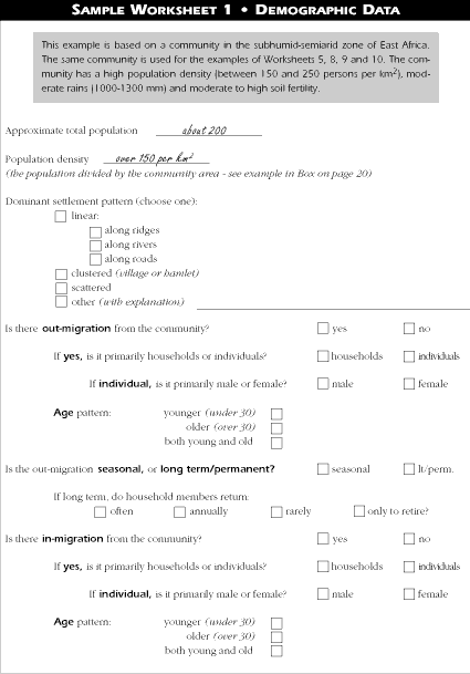
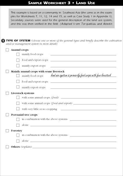
This case study is based on a planning exercise that was conducted in Asia (see Torquebiau and Abedin 1991). It is representive of the majority of tree planting projects since it combines predetermined objectives and species with some planning flexibility. Some tree species were preselected forestry species chosen by the Forestry Department, but planning was still needed for the selection of other species, as well as for determining niches and spatial arrangements for all the species.
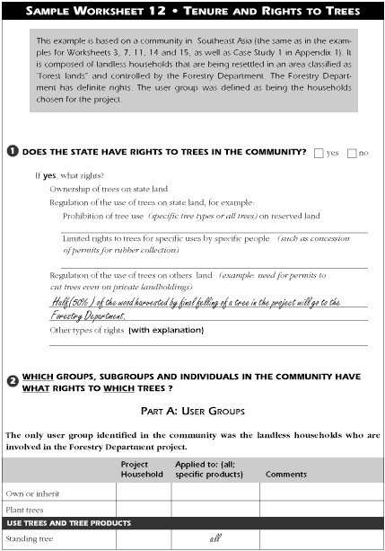
Background: In the country of the case study, increasing population pressure has resulted in the conversion of officially protected forest land into agricultural fields and settlements. Although large areas are still classified as "forest land" and under the jurisdiction of the Forestry Department, much of it is being farmed by landless encroachers. In some regions of the country only 15% of the land classified as "forest land" is actually forested.
Historically, the Forestry Department was mainly concerned with the enforcement of protective measures. Traditional forestry practices, however, have proven inadequate and the government has realized the necessity of people's participation in protecting the forest and in promoting agroforestry activities. Thus the government decided that the area of the case study would be brought under agroforestry with the active participation of the local landless people.
"Participation" in this case refers to the landless providing labour and management of their allotted parcels; participatory assessment was not part of the design process. The planning team made its recommendations based on its own determination of possible solutions to the needs of the community which would also meet the criteria of the Forestry Department.
The project is in many ways an example of "top-down" planning, with the primary project objectives being decided by the Forestry Department with no input from the community. However, the encroacher households were contacted by the planning team during the baseline and planning phase of the project. Information was collected on food, income, labour, shelter, etc. from the households and used in the project design.
The case study site was selected by the Forestry Department for the implementation of agroforestry practices and for a nursery project. Originally the site had been under sal (Shorea robusta), but now it had been cleared and settled by poor landless households. Each landless family will be resettled near the agroforestry site, and assisted by the Forestry Department to develop their homesteads and fields with trees and crops.
Before the planning team arrived at the case study site, the Forestry Department had determined the following specifications for the project:
With these specifications forming the framework of the project, the planning team was to design a project with the user groups (landless families and the Forestry Department) and some of the tree species already determined, but with niche, spatial arrangement, function, and additional tree species still to be identified.
The planning team used secondary sources and community-based information for the key information needed for the project design.
Secondary sources supplied information on rainfall, soils, growing period, physiography, demography, land use system, and rights to trees.
Community-based information was concerned with soil conditions (erosion, etc.), population, land use systems, current tree growing patterns (including those of landed farmers near the project site), user groups, household information (including income and expenditure patterns; seasonal calendar for household activities and priority list of needs), and rights to trees.
During the initial phase of planning, the team approached the project saying "let's observe what is the current reality in the community." A transect (Worksheet 4) was made through the community to determine current land use patterns (crops, trees, etc.) and land holdings (areas privately held and those controlled by the Forestry Department), and to identify visible problems (erosion, degradation, etc.) and stated problems (lack of fodder, fuel scarcity, etc.).
Information was gathered on the physical environment, community, household, and rights to trees. Information from secondary sources was verified in the community.
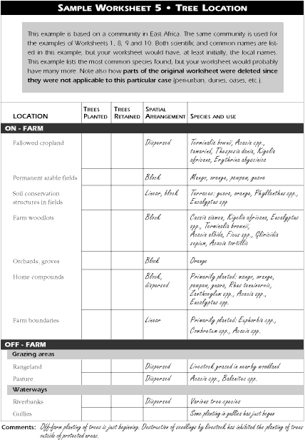
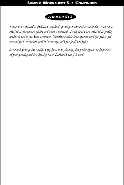
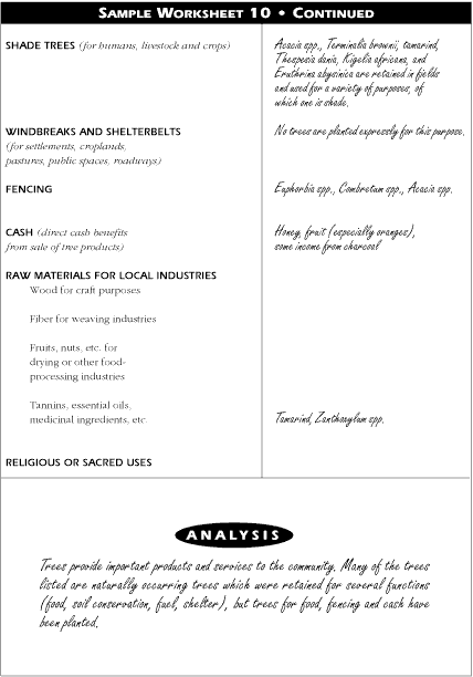
The tree growing practices of the landed farmers near the project area were studied since these practices illustrated what could be successfully grown and marketed in the area (Worksheets 5, 9 and 10).
Households in the community were interviewed to determine their priority needs (Worksheets 8 and 9). These needs served as the basis for determining the proposed functions of tree species.
Analysis of the collected data revealed that the households' priority list of needs was: food and cash, then fuel and shelter. All the households interviewed agreed on this list of needs. Households also mentioned the need for fencing and boundary demarcation to secure tenure on the land allotment, and remarked that trees provided opportunities for savings and investment. The planning team identified environmental problems (erosion, soil infertility) that trees could counteract. The Forestry Department specifications were also included in the analysis.
To meet the identified community needs (food, cash, fuel and shelter), four agroforestry technologies were designed which combined:
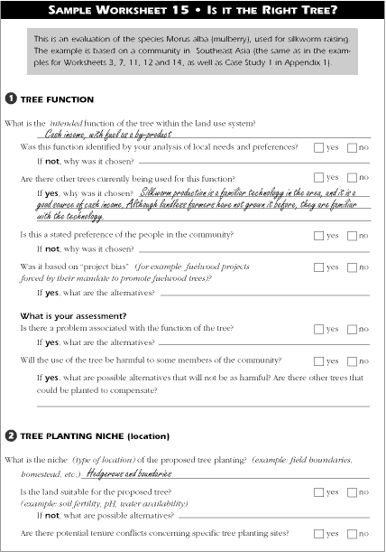
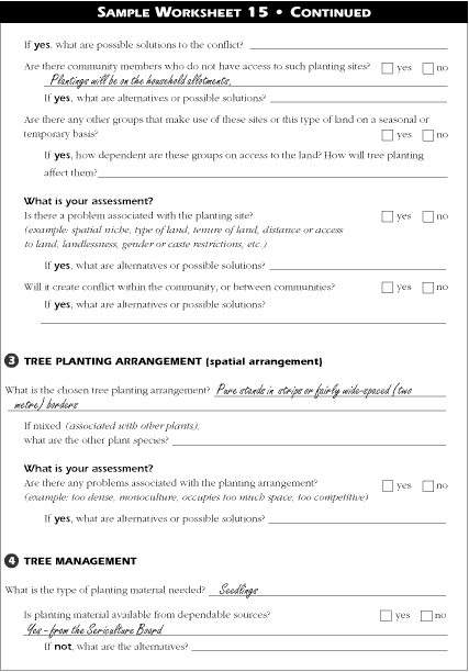
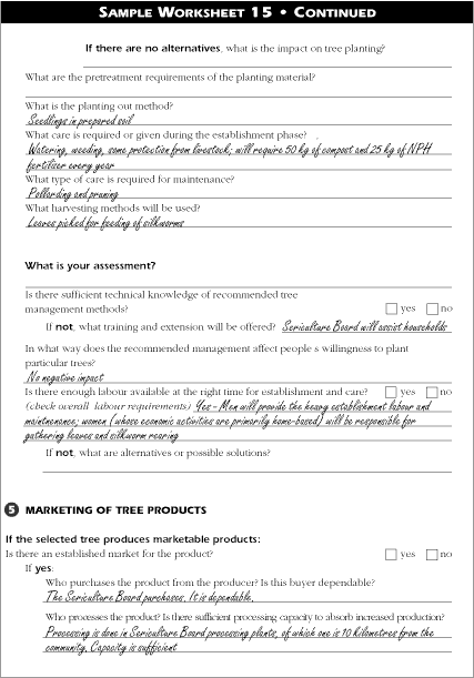
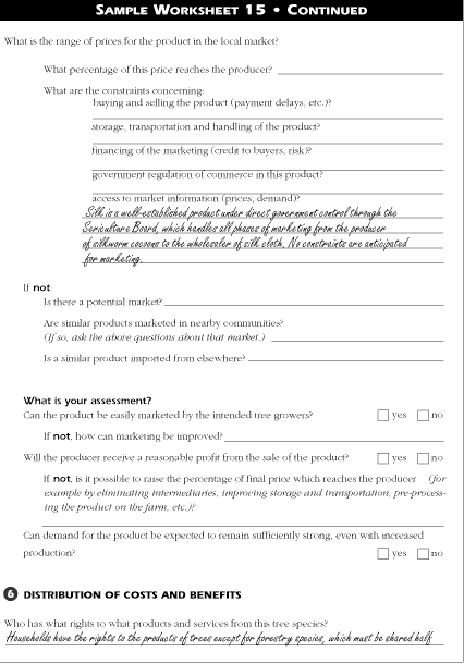
It was decided to propose tree species that were already being grown in the area by the landed households, although it was suggested for the fruit trees that better varieties be introduced. The forestry species were well known, particularly by the Forestry Department who will provide the seedlings and management recommendations. In total, over 20 tree species were proposed. Since landed families in the area were already involved in sericulture (growing of silkworms, which are fed with the leaves of the mulberry tree) and there was a developed market for the silk, mulberry for sericulture was suggested for cash income.
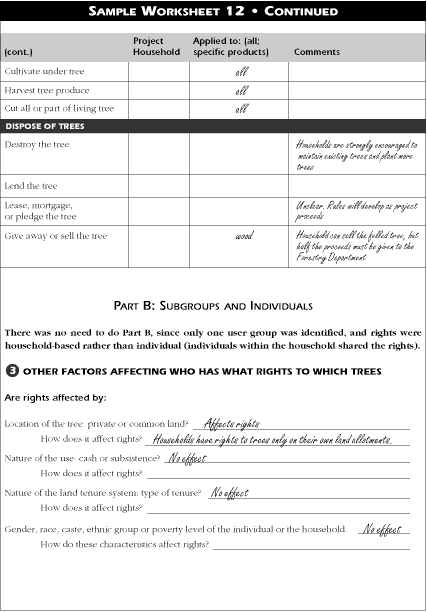
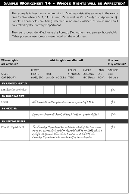
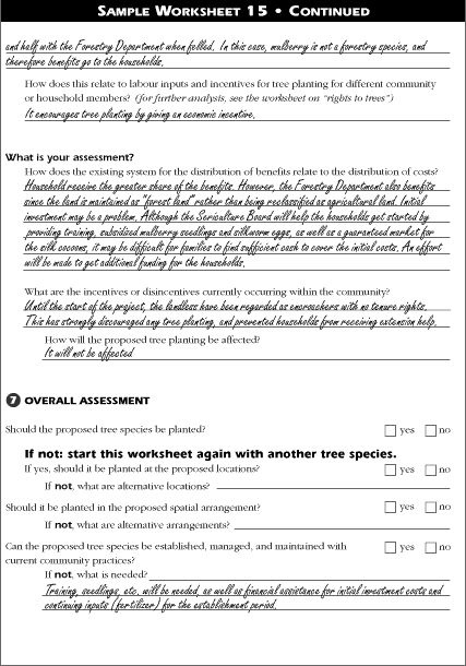
It was found that project participants gain rights to land and future crops and tree products produced on-farm. The Forestry Department gains potential tree production from the resettlement community, and maintains its rights to the area as "forest lands." (Worksheet 14; the Worksheet 14 example in Appendix 2 is based on this case study).
When re-examining the tree species, it was found that the trees that were chosen are suited to the physical environment, niche, and spatial arrangements. The labour requirements will result in more time spent on-farm than in the past, but production of crops should make up for the decline in male off-farm income. It is expected, however, that female labour will be used for many of the tree-related tasks on-farm, especially for sericulture. An analysis of mulberry (Morus alba) suggested that it would be an appropriate tree species for the community (Worksheet 15; the Worksheet 15 example in Appendix 2 is based on this case study). The trees will provide what the community identified as its most important needs, and should also help alleviate the environmental problems identified by the planning team. The trees support the current tenure; boundary plantings will support the land allotment claims of the households. All the households in the community should benefit. Seedlings and training will be provided by the Forestry Department, the Sericulture Board and other government agencies.
The final assessment was made by the Forestry Department and the community. Both agreed to the plan, and perceived it as fulfilling both their needs.
At a project site in Asia, trees were planted around the homestead, but few were found planted elsewhere. There was little vegetation, especially trees, found in the area. One of the project's first objectives was to determine the basis for the current pattern of tree planting.
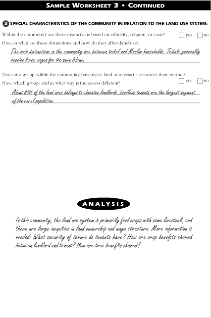
Information was collected on the the current pattern of tree growing in the community and on community needs (Worksheets 4, 5, 8 and 9). The priority needs of the community were identify as food and cash. The majority of households were marginal and small farmers who did not produce enough food to feed the households for the year. Households were forced to purchase food, thus, the strong need for cash. It was found that homesteads contained both indigenous and exotic trees planted for food, income, and building materials. Cow dung and crop residues, not trees, were used for fuel by the community.
The demographic analysis and the examination of land use patterns (Worksheets 1, 2 and 3) revealed that the community consisted of landowners, tenants (some of whom also owned small parcels of land), and the landless (about 20% of the community). Most of the land in the community was owned by relatively few absentee landlords. These landowners were not interested in the community and invested very little in infrastructure such as water tanks, drainage, and so on. The household profile (Worksheets 8 and 9) revealed that tenants did not have the rights to make decisions concerning the land they farmed. Lack of secure tenure and resources inhibited tenants from making improvements on the land.
Worksheet 12 (Rights to trees) revealed a major reason for the lack of trees planted off-homestead. Unlike crops, there was no clear understanding between the landowner and the tenant regarding the sharing of tree products. Neither community leaders nor community members could provide consistent details for the worksheet.
The planning team discussed this issue with tenants, owner/tenants, and absentee farmers. An agreement was reached on rights to trees:
This eastern African community is agropastoral (livestock with annual crops). Few trees are visible in the area, the pasture is very dry, and erosion is a serious problem. Given the absence of trees in the fields and grazing areas, it might initially appear that there were many niches available for planting trees. However, as locations were sought, it became apparent that more information was needed for the successful establishment of trees.
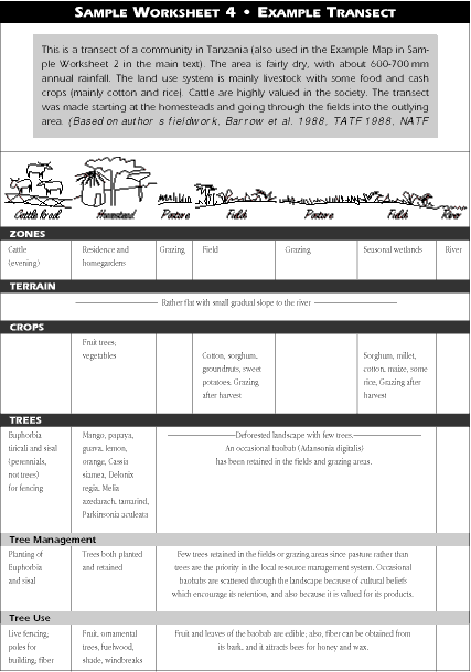
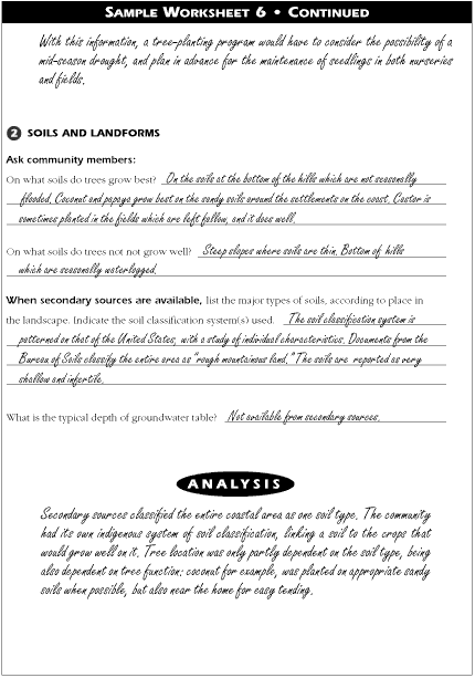
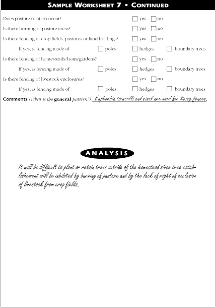
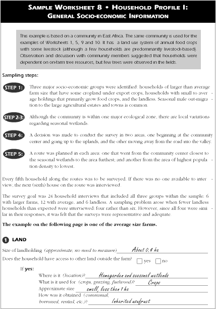
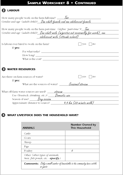
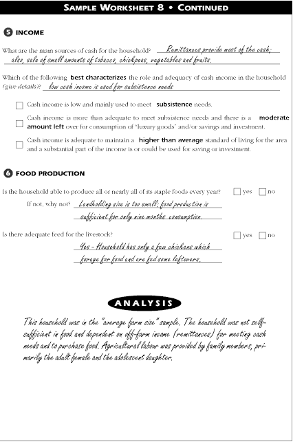
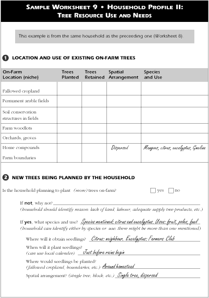
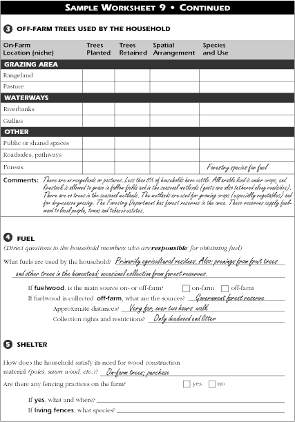
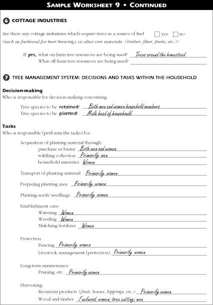
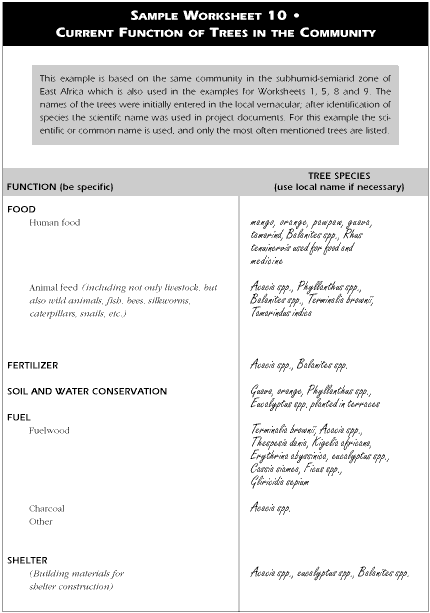
Background information collected from secondary sources reported that tsetse fly campaigns in the past had encouraged villages to clear trees and shrubs from the area. Through a transect (Worksheet 4; the transect from this case study is given in Appendix 2 as the example for Worksheet 4) it was found that trees were planted in the community, but only around the homestead or as fencing around the livestock corrals. An analysis of land use and production systems (Worksheets 3 and 7) focusing on livestock movement and management revealed that livestock grazed in post-harvest fallow fields. The household profile (Worksheet 9) reported that trees, primarily fruit, were planted in the homestead, and Euphorbia tiricali was planted as living fences, but none of the households had planted trees in the fields. The community profile emerging from analysis of the worksheet data (Chapter 4) supported the high value of cattle in the community.
Given these constraints, the niche initially identified was the homestead. Further discussion with community members supported the introduction of improved fruit trees, which could provide both food and cash.
A social forestry shelterbelt project in China had chosen three pilot sites in the province from which to collect information for project design and implementation. An important component of the project was the training of staff members on participatory rapid appraisal methods. A community in the pilot area was chosen as a training site. During a training course, information was gathered using the process and modified forms of the worksheets. Although it was a training exercise in identifying community needs and tree planting practices, it also became an informal evaluation of past and current policy and project activities.
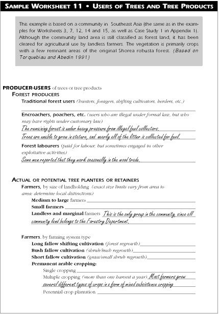
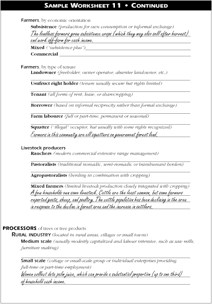
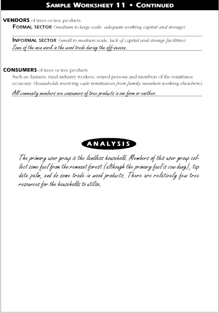
The community was officially listed as being very poor. Initially, information was collected at the community level, and information on the household was collected after a preliminary analysis of the community. Worksheets 2, 3, 4, 5 and 10 were used to collect information on the community land use and tree growing practices. Worksheets 8 and 9 were used for household information, and Worksheet 12 was used as the basis for gathering information on who had what rights (including decision-making rights) concerning trees.
Community members wanted to gain management control of land designated as community land. The feeling in the community was that tree species chosen for the community did not fulfill stated needs (the projects's "economic tree" was not economic, and the trees on community forest land could not be utilized by the community).
The community proved to be an excellent example of the difference between official records and what is actually occurring. Although classified as "poor", the community was prosperous. Unreported income from illegal migration by young adults from the community to the urban areas for wage employment provided the funds for improved housing, agricultural investments, appliances, and clothing. A high proportion of the houses were new, two stories high, of modern construction, and had electricity, although running water was not common. A combination of reduced population pressure on the land due to out-migration and the income from the urban areas had greatly improved the living conditions of the community. Food production was more than adequate to meet household needs, and agricultural production for income was the need most expressed.
An analysis of trees in the community revealed that there were only eight tree species present. The area had undergone complete deforestation since 1950. The numerous changes in policy during the period from 1950 to 1980 concerning land rights and management had created a wariness by the farmers of long-term investment (such as tree planting) on land other than the homestead. Decision-making concerning tree species was made outside the community. The "community forest" that the community had planted and was responsible for protecting (but not allowed to thin or maintain) was on community land that project planners had decided should be removed from agricultural production and planted to a tree species (Acacia rubinia) that the community regarded as having little value (providing neither food nor income). The "community orchard" contained several varieties of oranges that were chosen by the project planners as "economic" trees. However, due to a glut of oranges in the area, there was little economic gain. Community members expressed their frustration with policies that excluded them from decision-making and did not allow them to manage the forest and orchards designated as "community" areas. The community, for example, was not allowed to cut the orange trees and replace them with another income-earning tree, nor were they allowed to manage the acacia forest.
Community members also explained the problems that current policies created for tree-growing on the farm. Because agricultural land was allotted to the household based on the number of family members, a change in the family size through out-marriage or death meant the loss of part of the land allotment. If trees were planted on the land, when it was reallocated the household that had planted the trees lost their rights to them. In some cases where the new holders of the land were approached for compensation to the planters, they refused. This lack of clear rights to trees planted discouraged tree-planting outside of the homestead. Even on the homestead, farmers were strongly encouraged to plant certain tree species. Since the tree species available were few, the options for farmers were quite narrow.
A farmer approached a field worker of a tree planting project. She wanted information on possible tree species for the family farm. Her husband worked outside the area and could only get home a few times a year. The farm was recognized as belonging to her husband, so she would have to get his approval regarding the trees which could be planted. During the next month she wanted to consider the possibilities so she could discuss it with him on his next visit and obtain his permission.
She had already decided on the function of the tree. She wanted a fruit tree so that she could sell the fruits in the town where her sister lived. The field worker's project already had expressed an interest in identifying fruit trees that would both grow well in the area and provide income. The field worker had been in the community long enough to recognize that the needs of this farmer were shared by many other households. The farmer and field worker agreed to work together in identifying potential fruit tree species.
The first step focused on the existing fruit trees in the community, local markets, and physical environment. Since the farmer wanted a fruit tree primarily to provide income, using the tree location and function worksheets (4, 5 and 10), they made a list of all the trees that were used for fruit and what fruit they knew to be sold.
Using the indications in Worksheet 15, part 5 ("Marketing of tree products"), the farmer and her sister made an informal survey of the market where the sister lived, and spent an afternoon talking to vendors. They were interested in knowing which fruits were getting the best prices. On his trips around the area, the field worker went to other local markets to see if additional fruits were being sold. He was able to follow several fruits to the city markets. He also asked other field workers in the area and those in other projects what was occurring in local fruit markets and the availability of fruit tree seedlings.
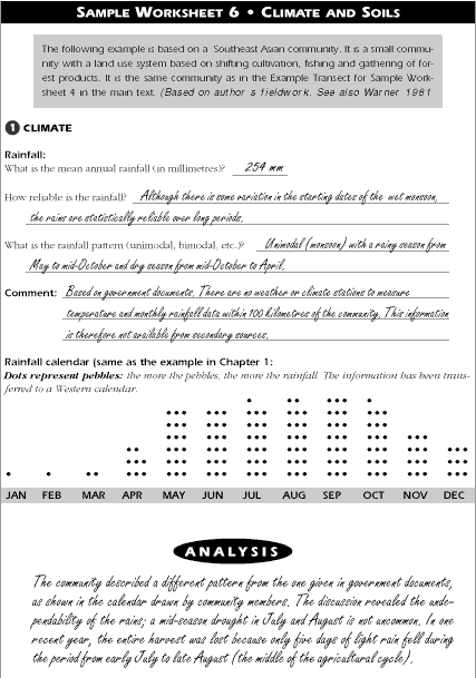
The field worker checked extension material to see what fruits were recommended based on the physical environment of the area. He compiled a physical environment profile using Worksheet 6. Since he had only lived in the area for two years, he checked the information, especially the dependability of the rains, with members of the community.
Using Worksheets 8 and 9, the field worker and farmer created a household profile. There were four children, ranging in age from a baby to an eleven-year-old. The household had one hectare of land, which was about average for the area. It was located on the side of a small hill with a stream about a fifteen minute walk from the house. The homestead and fields were next to each other. Major crops grown were maize, bean, and banana. There was one cow. Some off-farm grazing was available, but on-farm fodder was needed. The farmer provided most of the labour, but the older children helped when not in school. The major source of income was remittances from her husband who worked and lived outside the area. However, the amount from her husband was not enough. School fees were increasing, and as the younger children got older, more income would be needed to pay their fees.
Currently, trees were found in the home compound and in the fields. In the past, the protection of naturally occurring trees had been the predominant means of tree establishment. Now, however, especially valued trees were being planted. On the farmer's landholding, the fruit trees were mango, citrus, and papaya. Four mango trees were scattered in the croplands. These were old trees that had been planted or protected by the farmer's father-in-law years before. There were also several more recently planted mangoes in the home compound, as well as several citrus trees and papaya. Some of the papaya had grown "naturally," meaning that it not been planted. Although the farmer sold some mango and citrus to neighbors and occasionally at the local market, the quality was not good. The papaya grew well, but there was a very limited market for the fruit.
The farmer planned to plant the trees in the homestead area where it would be easier for her to provide care and protection. Also, customary rights gave her more autonomy in decisions concerning the homestead than the fields, and more control over its products.
The field worker and farmer discussed the possibilities (Chapter 5). Avocado was fetching a high price in markets in the area. However, avocado (Persea americanus) was only grown where rainfall was higher and less erratic than in the farmer's community. Also the leaves and bark were toxic to livestock, so it could not be used as fodder. Jackfruit (Artocarpus heterophyllus) could grow well in the local climate and the leaves and fruit could be used for fodder. Seedlings were available through the project, but although it was grown elsewhere in the country, there was little local knowledge about it and a limited market for it in the area. The field worker had access to improved citrus and mango varieties and could provide them at a small but affordable cost. The market for citrus was well established, and there was a growing demand for the newer varieties of mango.
The farmer was curious about the jackfruit. She had eaten it several times and found it too sweet, but the field worker told her that it could also be cooked when green and eaten as a vegetable. Other field workers in the areas where it was grown reported that a market for the fruit had gradually developed. That it could also be used as fodder provided an additional incentive. The farmer decided to plant improved citrus and several jackfruit. The citrus were early maturing varieties and whereas they would require intensive care during the establishment phase, she thought that the better quality fruit would provide the needed income. Her decision not to plant mango was based on the size of the tree and the already existing mango trees on her farm. It is a large tree and she was reluctant to put more land under a fruit tree that she already had in large amounts.
Note: Worksheets 2 and 13 have no examples in this appendix. Since Worksheet 2 is the community map, of which an example is already given in the main text, and Worksheet 13 is simply a list of ideal tree characteristics with no questions to answer.


Barrow, E, Kabelele, M., Kikula, I. & Brandstrom, P. 1988. Soil conservation and afforestation in the Shinyanga region: potentials and constraints. Report to Norad. April, 1988.
Bruce, J.W. 1989. Rapid appraisal of tree and land tenure for the design of community forestry initiatives. Madison, Wisconsin, U.S.A.: the University of Wisconsin Land Tenure Center.
Chambers, R. 1984. To the hands of the poor: water, trees and land. Discussion Paper Series. New Delhi, India: Ford Foundation.
Chambers, R. 1987. Trees to meet contingencies: savings and security for the rural poor. Network Paper 5a. Social Forestry Network. London, U.K.: ODI.
Davis-Case, D. 1989 Community forestry: participatory assessment, monitoring and evaluation. Community Forestry Note 2. Rome, Italy: FAO.
Davis-Case, D.The community's toolbox: The idea, methods and tools for participatory assessment, monitoring and evaluation in community forestry. Community Forestry Field Manual 2. Rome, Italy: FAO.
Djimde, M. & D.A. Hoekstra (eds). 1988. Agroforestry potentials for the land use systems in the bimodal highlands of eastern Africa: Uganda. AFRENA Working Paper No.4. Nairobi, Kenya: ICRAF.
Djimde, M. & J.B. Raintree (eds). (no date) Agroforestry potential in the humid lowlands of Cameroon. AFRENA Report No.12. Nairobi, Kenya: ICRAF.
FAO. 1985. Tree Growing By Rural People. FAO Forestry Paper 64. Rome, Italy: FAO.
Fortmann, L. 1987. Tree tenure: an analytical framework for agroforestry projects. In: J.B. Raintree (ed). Land, Trees and Tenure: Proceedings of an International Workshop on Tenure Issues in Agroforestry. Nairobi, Kenya: ICRAF and Madison, Wisconsin, U.S.A.: the University of Wisconsin Land Tenure Center.
Fortmann, L. & J.W. Bruce. 1988. Whose Trees?: Proprietary Dimensions of Forestry. Boulder, Colorado, U.S.A.: Westview Press.
Fortmann, L. & J. Riddell. 1985. Trees and Tenure: An Annotated Bibliography for Agroforesters and Others. Nairobi, Kenya: ICRAF and Madison, Wisconsin, U.S.A.: the University of Wisconsin Land Tenure Center.
Fortmann, L. & D. Rocheleau. 1985. Women and agroforestry: four myths and three case studies. Agroforestry Systems 2(4): 253-272.
Hardcastle, P.D. 1987. Microplanning for social forestry: a description of the system designed for Karnataka's social forestry project, India. Network Paper 4c. Social Forestry Network. London, U.K.: ODI.
Hoskins, M. W. 1980. Community forestry depends on women. Unasylva 32(130): 27-32. Rome, Italy: FAO.
Hoskins, M. W. 1982. Observations on indigenous and modern agroforestry activities in West Africa. Paper presented at the United Nations University Workshop on Problems of Agro-Forestry. June. Germany: University of Freiburg.
ICRAF & ICAR. 1984. Report of the joint ICAR/ICRAF diagnostic and design exercise at the Bhaintan watershed in the outer Himalaya of Uttar Pradesh. Nairobi, Kenya: ICRAF.
ICRAF & ICAR. 1986. Diagnosis of land use systems and designs of agroforestry interventions for the drylands of Karnataka. Nairobi, Kenya: ICRAF.
ICRAF, INIPA, INFOR, IVITA, CIAT & NCSU. 1982. Research project on developing agroforestry systems for the upper basin of the Peruvian Amazon. Nairobi, Kenya: ICRAF.
ICRAF, MAG & CATIE. 1984. Development of improved agroforestry systems for seasonally dry uplands of western Costa Rica. Nairobi, Kenya: ICRAF.
Kaale, B.K. 1984. Trees for Village Forestry. Dar es Salaam, Tanzania: Forest Division, Ministry of Lands, Natural Resources and Tourism.
Kajomulo-Tibaijuka, Anna. 1985. Factors influencing the cultivation of firewood trees on peasant farms: a survey on smallholder banana-coffee farms, Kagera region, Tanzania. Rural Development Studies No.18. Uppsala, Sweden: Swedish University of Agricultural Sciences.
Kamau, I.N. & J. Odra (eds). 1988. A blueprint for agroforestry research in the unimodal upland plateau of Tanzania. AFRENA Working Paper No.6. Nairobi, Kenya: ICRAF.
Kwesiga, F. & I.N. Kamau (eds). (no date) A blueprint for agroforestry research in the unimodal upland plateau of Zambia. AFRENA Working Paper No.7. Nairobi, Kenya: ICRAF.
Kwesiga, F. & E. Sabas (eds). (no date) Agroforestry research project for the Sukuma agro-pastoral system in the unimodal upland plateau (Mwanza-Shinyanga region) of Tanzania. AFRENA Working Paper No.9. Nairobi, Kenya: ICRAF.
Minae, S. (ed). 1988. A blueprint for agroforestry research in the unimodal upland plateau of Malawi. AFRENA Working Paper No.5. Nairobi, Kenya: ICRAF.
Minae, S. (ed). 1989. Agroforestry research project proposal for the coffee based system in the bimodal highlands, Central and Eastern Provinces, Kenya. AFRENA Working Paper No.16. Nairobi, Kenya: ICRAF.
Molnar, A. 1989. Community forestry: rapid appraisal. Comunity Forestry Note No.3. Rome, Italy: FAO.
National Agroforestry Task Force (NATF). 1988. A blueprint for agroforestry research in the unimodal upland plateau of Tanzania. AFRENA report no.6. Nairobi, Kenya: ICRAF.
Ogden, C.L. 1991. Guidelines for integrating nutrition concerns into forestry projects. Community Forestry Field Manual No.3. Rome, Italy: FAO.
Raintree, J.B. 1987a. D&D User's manual. Nairobi, Kenya: ICRAF.
Raintree, J.B. (ed). 1987. Land, trees and tenure: proceedings of an international workshop on tenure issues in agroforestry. Nairobi, Kenya: ICRAF and Madison, Wisconsin, U.S.A.: the University of Wisconsin Land Tenure Center.
Raintree, J.B. 1989. La "D&D": manuel de l'utilisateur. Nairobi, Kenya: ICRAF.
Raintree, J.B. 1990. Theory and practice of agroforestry diagnosis and design. In: K.G. MacDicken and N. Vergara (eds). Agroforestry: Classification and Management. New York, U.S.A.: John Wiley.
Raintree, J.B. 1991. Socio-economic attributes of trees and tree planting practices. Community Forestry Note No.9. Rome, Italy: FAO.
Raintree, J.B. & M. Hoskins. 1988. Appropriate R&D support for forestry extension. In: RWEDP. Planning Forestry Extension Programmes. Report of a Regional Expert Consultation. Regional Wood Energy Development Programme in Asia. GCP/RAS/111/NET Field Document No. 8. Bangkok, Thailand: FAO Regional Office for Asia and the Pacific.
Raintree, J.B. & K. Warner. 1986. Agroforestry pathways for the intensification of shifting cultivation. Agroforestry Systems 4(1): 39-54.
Rocheleau, D.E. 1983. Ecosystems analysis in D&D applications. In: ICRAF. Resources for Agroforestry Diagnosis and Design. ICRAF Working Paper No.7. Nairobi, Kenya: ICRAF.
Rocheleau, D.E. 1986. The user perspective and the agroforestry research and action agenda. In: H.L. Gholz (ed). Agroforestry: Realities, Possibilities and potentials. Dordrecht, Netherlands: Martinus Nijhoff.
Rocheleau, D.E. 1987. Women, trees and tenure: implications for agroforestry research and development. In: J.B. Raintree (ed). Land, Trees and Tenure: Proceedings of an International Workshop on Tenure Issues in Agroforestry. Nairobi, Kenya: ICRAF and Madison, Wisconsin, U.S.A.: the University of Wisconsin Land Tenure Center.
Rocheleau, D., F. Weber & A. Field-Juma. 1989. Agroforestry in Dryland Africa. Nairobi, Kenya: ICRAF.
Scherr, S.J. 1987. Planning national agroforestry research: guidelines for land use system description. ICRAF Working Paper No.48. Nairobi, Kenya: ICRAF.
Scherr, S.J. 1989. The D&D approach to agroforestry project planning and implementation: examples from western Kenya. International Symposium on Planning for Agroforestry. April 1989. Pullman, Washington, U.S.A.: Washington State University.
Scherr, S.J. & P. Oduol. 1989. Alley-cropping and tree borders in crop fields in Siaya District, Kenya. Nairobi, Kenya: ICRAF and CARE.
Tanzania Agroforestry Task Force (TATF). 1988. Agroforestry research project for the Sukuma agro-pastoral system in the unimodal upland plateau (Mwanza/Shinyanga region) of Tanzania. AFRENA report no.9. Nairobi, Kenya: ICRAF.
Torquebiau, E. (ed). 1991. Agroforestry research planning for the High Barind Tract, Rajshahi, Bangladesh: Report of a Diagnostic and Design Survey. Dhaka, Bangladesh: Bangladesh Agricultural Research Institute (BARI) and Bangladesh Agricultural Research Council (BARC), and Nairobi, Kenya: ICRAF.
Torquebiau, E. & M.Z. Abedin (eds). 1991. Agroforestry technologies for an encroached forest area in Dhaka Division, Bangladesh. Dhaka, Bangladesh: BARC and Nairobi, Kenya: ICRAF.
Tschinkel, H. 1984. Tree planting by small farmers in upland watersheds: experience in Central America. IX World Forestry Congress. Mexico City, Mexico.
Vergara, N., C. Tingsabash, K. Johnson, V. Vidyarthi & R. Bowen. 1986. Social forestry research issues: preliminary problem identification in Sisaket Province, Northeast Thailand. ODI Social Forestry Network Paper 2b, May 1986. London, U.K.: ODI.
Vonk, R.B. 1983. A study on possible agroforestry tree species for the Kathama area. M.S. Thesis. Wageningen, Netherlands: Department of Silviculture, Wageningen University.
Warner, K. 1981. Swidden strategies for stability in a fluctuating environment: the Tagbanwa of Palawan. In H. Olafson (ed.), Adaptive Strategies and Change in Philippine Swidden-Based Societies. Laguna, Philippines: FORI.
Warner, K. 1991. Patterns of Farmer Tree Growing in Eastern Africa: A socio-economic analysis. Paper presented at the Workshop on Socio-economic Aspects of Tree Growing by Farmers, 11-14 March 1991. Anand, India: Institute of Rural Management.
Warner, K. 1993. Patterns of Farmer Tree Growing in Eastern Africa: A Socio-economic Analysis. Oxford, U.K.: Oxford Forestry Institute and Nairobi, Kenya: ICRAF.
Young, A. 1989. Agroforestry for Soil Conservation. Wallingford, U.K: C.A.B. International.
