


There are two classifications of the agro-ecological zones where Maraba and Karama are located. According to a classification using climatic data (Delepierre, 1974), Maraba and Karama are both located in the Central Plateau. But according to a diagnosis and design (D&D) exercise conducted by ICRAF that used socio-economic variables, soils characteristics and actual land use systems in addition to climatic data, Maraba and the eastern and central sections of Karama belong to the Zone des Plateaux et Collines, but the extreme western part of Karama is part of the Zaire-Nile Divide zone (Djimde, et al, 1988).
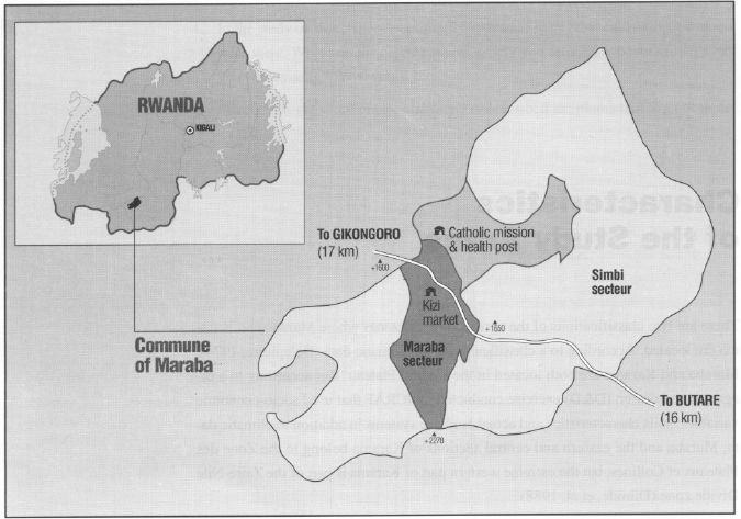
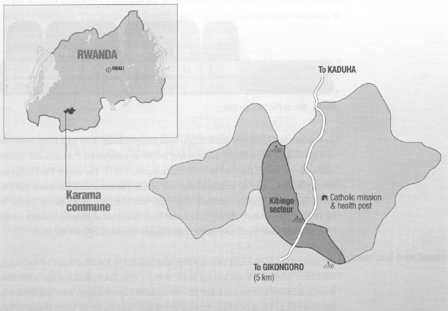
Maraba is located in the western part of Butare Prefecture and borders Gikongoro Prefecture (see Map 4). It is bisected by the main, paved road from Butare to Gikongoro and Cyangugu. Maraba has gentle, sloping hills dissected by numerous streams with fertile valleys that are intensively cultivated, especially during the dry season. The slopes become steeper in the south where the Huye mountain chain forms a border with neighbouring municipalities. The highest point in the Huye mountain chain is 2,278 m. Practically all land up to about 2,050 m is cultivated or occupied by communal forests. However, due to increasing pressure on the land, new farms are being carved out of the pastures and forests above that level.
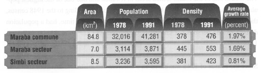
The area is one of the oldest settled areas in Rwanda and had one of the highest population densities in the country before Independence. According to the 1948 census, the Bwanamukare region, to which Maraba belonged at the time, had a population density of 183 persons per km2 with 356 persons per km2 of arable land (Prioul, 1981).
Since the census of 1948 was based on a different administrative division, data from that census cannot be compared directly with those taken later. However, taken on a population per square kilometre basis, the population density has increased by more
than 300 percent since 1948. The growth rate, however, was lower than the national average of 3.1 percent during the 13 years between the last two censuses, in 1978 and 1991. The lower population growth rate can be explained by the out-migration resulting from land scarcity. Most have migrated to the Mayaga region in eastern Butare, Bugesera in southern Kigali Prefecture and Kibungo Prefecture in the eastern part of the country. Less than one quarter of the population has migrated within Maraba, principally by carving out farms on steep slopes and former pastures only marginally suited for agriculture.
SOURCE: Min. du Plan 1982 and 1992

SOURCE: Commission Communale de Planification 1989
The high population density is also reflected in the size of the farms in Maraba. More than half the households cultivate less than 0.25 ha of land, with only 14 percent of the households cultivating more than 1.5 ha (Figure 3). Farm size appears to be independent of household size, since the amount of land cultivated does not increase with the number of persons in the household and farmers with more land do not necessarily have more children. For example, the majority of households of more than eight persons still cultivates less than 0.25 ha. Given the traditional inheritance pattern of dividing the land equally between sons, it is not difficult to imagine the future of farming in Maraba.
SOURCE: Commission Communale de Planification 1989
SOURCE: Commission Communale de Planification 1989
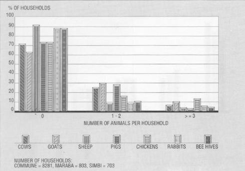
Livestock rearing was prominent in Maraba before Independence, when large tracts of land were reserved for the royal cattle. Due to increasing population pressure and declining farm sizes, the majority of households can no longer afford to keep animals. Nearly 62 percent of all households have no animals, the others have only one or two. Goats are becoming more numerous than cattle, a reflection of decreasing farm sizes and lack of sufficient pasture for larger animals. Figure 5 shows the distribution and the number of different animals per household.
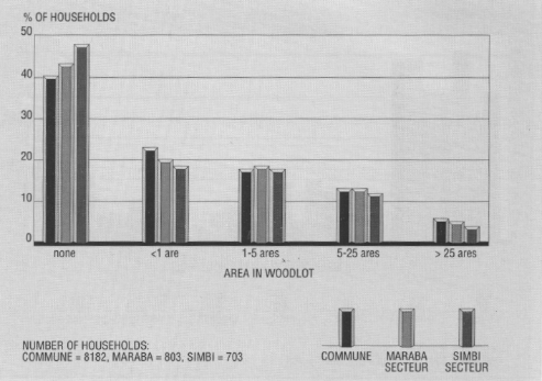
Also, a majority of houses can no longer afford to keep woodlots. On average, 40 percent of households in Maraba do not have woodlots. Existing woodlots are usually very small, less than 500 square meters.
There is a small market twice a week on the border between Maraba and Simbi that attracts farmers from a wide area. During the coffee marketing period from June to September, many merchants try to sell their wares (cloth, used clothes, luxury items, hardware, etc.) to take advantage of the flush of money during these weeks. The buying and selling of animals also is more active during this period, with many farmers selling off their animals before they lose weight in the dry season.
Social conditions: Simbi and Maraba districts each have one primary school. The Simbi school is run by the Catholic mission, while the school in Maraba is a state school. The mission also operates a small clinic, maternity and health education centre.
SOURCE: Commission Communale de Planification 1989
The two districts have good drinking water in centrally-located spigots. A municipal employee maintains the water pipes, spigots and water tanks. There is also a national electricity network which few can afford.
Karama is in Gikongoro Prefecture approximately five km north of Gikongoro town and 36 km from Butare (see Map 5). The dirt road between Gikongoro town and Karama is a major road and is passable year-round. Karama is at a higher elevation than Maraba and covers two agro-ecological zones, Plateaux et Collines in the east and the Zaire-Nile Divide in the west. Eastern Karama looks much the same as Maraba, with rolling hills intersected by many streams and valleys. Kibingo is located between the two zones where there are steep hills with narrow valleys, and gully formations and landslides are common. As a result, Kibingo has only a few springs which are trickles originating from numerous places along the hill crest. The western and southern borders of Kibingo are formed by wide valleys whose cultivation is shared with farmers from other districts. Parts of these valleys have been improved with better drainage systems and improved field arrangement.
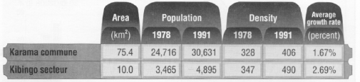
Before Independence, Karama belonged to the chieftaincy (chefferie) of Bufundu. Bufundu roughly covered the area of the present municipalities of Mudasomwa, Nyamagabe, Kinyamakara, Karama, and Rukondo. According to Noel Macumu (pers. com.), a former sub-chief (sous-chef), the entire area of Bufundu had less than 20,000 population in 1955. By 1978, the population of Karama alone was 24,716 with a pop ulation density of 328 person per km2 (Delepierre, 1980). According to the census of 1991, the population had reached 30,631, and the population density increased to 406 person per km2. In the period between 1978 and 1991, the population of Kibingo increased from 3,465 to 4,895, while the population density increased from 347 to 490 persons per km2. From Table 4, it can be seen that population growth rates in Karama were much lower than the national average of 3.1 percent between 1978 to 1991. The growth rate for Karama is comparable to Maraba's. However, the rate for Kibingo has been much faster, indicating that people still see opportunities to expand farming by bringing pasture land into cultivation and thus see less need to migrate out of the district.
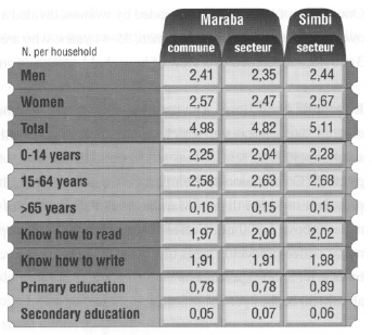
The average household size in Karama is 4.87, which is slightly above the national average but less than Maraba.
Economic conditions: As in Maraba, the main occupation of people in Kibingo is farming. The crops grown are much the same, except for bananas and coffee. Kibingo is a long, L-shaped ridge ranging in elevation from about 1,700 m in the southeast to 2,100 m in the centre and about 1,800 m in the north. Most of Kibingo is, therefore, above the range for bananas. Farmers do not grow much coffee, because Kibingo was almost exclusively pasture land until Independence, with crop cultivation limited to the area immediately surrounding the home compound. Pastures still occupy about 40 percent of the land area (Technosynesis, 1987).
SOURCE: Min. du Plan 1982 and 1992
The major food crops are sweet potatoes, cassava, sorghum, peas and beans. The latter crop has made rapid inroads into the farming systems since the introduction of climbing beans by ISAR/CIAT. Previously, farmers produced bush beans but aluminum toxicity caused by soil acidity and over-cultivation and diseases almost destroyed the crop.
Because of the presence of two development projects in Karama, many of the valleys have been improved in the last ten years, streams have been canalized and a fish bone pattern drainage system installed. However, these improvements have not benefitted the majority of farmers. Many farmers previously had access to small pieces of land in the valleys but after improvement, the land was redistributed to "cooperatives" to which mostly wealthier farmers belong. Thus, small marginal farmers have been cut off from a valuable source of land for dry season cultivation critical to their family's survival.
Cattle ownership is more prevalent than in Maraba as there are still extensive areas in pasture. Many farmers raise goats and sheep, but there are fewer chickens, bees. pigs or rabbits than in Maraba. Land pressure is not (yet) as extreme as in Maraba, so farmers can still afford large animals and have not been forced to abandon their traditional attachment to cattle.
There is no market in Karama, although some farmers sell their produce daily near the secondary school and many travel five km to the Saturday market in Gikongoro town.
Kibingo's roads are in bad condition. The bridges are unstable and roads that are passable in the dry season are almost impossible after a rain. A food-for-work project started in late 1992 to maintain the internal road system should make some more isolated areas more accessible.
Social conditions: There are no primary schools located in Kibingo. Children walk to the mission school in Cyanika or the government school in Buhiga along the main road to Gikongoro. The mission in Cyanika also runs a small clinic and maternity, as well as a secondary school.
There was no running water in Karama until the end of 1992, when a water system with centrally- located spigots became operational. This system extended into Kibingo, but not all areas have spigots. Electricity is available in Cyanika but not in Kibingo.
Because Kibingo was settled later than the districts in the eastern part of Karama, the settlement pattern is somewhat different. Most households are scattered over the hills, but some houses are located along the roads (particularly in the southeast) and in groupings in the north. This settlement pattern was chosen to conserve cultivable land. Houses were built on flat hilltops or land unsuitable for cultivation (too shallow, rocky, etc.). The fact that the hills are much steeper in Kibingo than in the research sites in Maraba also forced people to concentrate their dwellings on more level ground.
By law, all land belongs to the state in Rwanda. However, farmers have permanent usufruct rights, which can be passed on from father to son. Because usufruct rights are permanent and heritable, farmers consider themselves to have ownership over the land even though they do not have formal title deeds. Officially, land cannot be sold, but due to economic hardship (especially among near-landless farmers) an increasing number of plots is sold surreptitiously. Women do not have rights to land and are not allowed to own it. Widowed heads of household manage the land of their deceased husbands and can make decisions about its use, but they do not accrue any ownership rights over the land. These women merely function as temporary caretakers for their sons, and when the latter so wish, they may reclaim all land without granting usufruct rights to their mothers. Divorced women are often in a more precarious situation, since they cannot claim even caretaker status for the land and cannot gain access to land independently.
Ownership rights to trees are independent of ownership rights to land. Women cannot own trees, but an exception is made for female heads of household. People justified single women's ownership of trees with the statement that translates roughly as "Women without husbands are men". As single women are equated with men, they can also plant trees and make farm management decisions, something which is not allowed of married women. The latter ruling is due to the fact that the land is owned by the husband. However, local custom does allow married women to plant medicinal and fruit trees on their husbands' land, as it is women's traditional role to feed and care for the family.
7 Since we were not able to obtain a copy of the Communal Development Plan for Karama commune, the information in this section is less detailed and exhaustive than that provided for Maraba.
