


The Royal Government of Bhutan selected Pema Gatshel as a representative district for a detailed study on the problems and practices of shifting cultivation in the country. The findings and conclusions presented in this case study are the result of extensive field visits in all the blocks of the district, including 18 village meetings and a survey covering 180 households. Field survey information was verified by extensive reviews of literature and of several district records available in the Pema Gatshel district office. The results of the study are presented in this chapter. These findings are considered to be reasonably representative of the overall problems of shifting cultivation in Bhutan, as well as those of many similar high altitude shifting cultivation areas in other parts of the world, and they are used to propose alternatives to this system of land use.
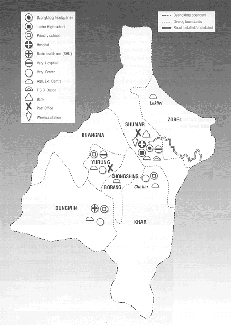
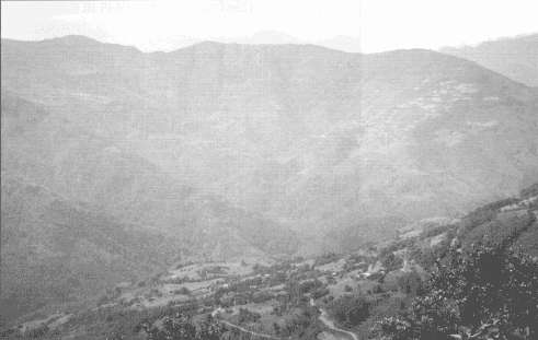
Pema Gatshel lies in the east-central part of Bhutan, and has a total area of 490 km2. The district is divided into seven "blocks" for all administrative purposes; they are Chimong, Chongshing Borang, Dungmain, Khar, Shumar, Yurung and Zobel. The land form is a moderately to steeply sloping mountainous terrain with limited areas occupied by ancient river terraces. River valleys are narrow and flood plains are restricted to narrow strips along the river beds.
The district represents the middle mountain chain of the eastern Himalayas and is characterized by moderately high altitude (300 - 2 500 m). It represents the catchment area of the Manas River and the main tributaries that drain different blocks in the district are Zalle Ri, Demri Chu, Uri Chu and Hyu Ri. The stream network of this district is very dense. Stream gradients are steep and drop suddenly when they enter valleys.
Soils are extremely variable, reflecting the differences in bedrock, geomorphology, microclimate and land use. The texture varies from sandy loam to clay loam. In tsheri land soil is generally poor. Soils are generally shallow, varying from 5 to 100 cm; PH varies from strongly acidic to alkaline; and varying degrees of stoniness and rockiness can be observed in tsheri land and dry land.
The range in climate of Pema Gatshel is from subtropical to lower temperate. At approximately 1 600 m the climate is cool and misty during most months of the year. At an elevation of 2 000 - 2 500 m the climate is usually quite variable, generally temperate, with distinct changes in season. In the subtropical zone daily temperatures vary from 15° to 30° C and in the temperate zone the variation is from 5° to 24° C.
Rainfall data has only recently been collected at three points. At the station in Pema Gatshel average rainfall from 1986-87 was 1 921 mm. In 1991, rainfall was recorded in Yurung at 2 301 mm and in Dungmain at 2 720 mm. The pattern of rainfall is generally evenly distributed, having a peak during July in all points of the district. Dry months are November and December as well as the latter part of July. Hailstorms present a definite hazard every year to crops over half of the district (Khar, Shumar, Dungmain and Chongshing blocks), whereas the remaining area suffers from hail at least once every three years. Frost is usually for a period of two weeks each year in all blocks, and it is of greatest intensity in Zobel, Shumar, Khar and Yurung blocks.
Forest vegetation in the study area consists of subtropical forests between 500 and 2 000 m and temperate forest at over 2 000 m. At 68 percent, forest cover in the Pema Gatshel district is slightly higher than the national average. Most of the forest land is found above 2 000 m, on slopes over 80 percent and along streams and riverbanks, and includes the four forest types described below.
The total growing stock is about 6.6 million m3, the net growing stock is 5.4 million m3 and the net annual yield is about 180 000 m3 (DOF, 1986). Soils in the forest areas are rather acid and consist of loamy sand, silt loam and sandy loam. Levels of nutrients are low, though the soils are of good composition, and even on steeper slopes, the shallow topsoil overlies subsoil and weathered parent rock with relatively good root permeability. Topsoils and level of humus are deeper than in cultivated areas.
Two forest types predominate in subtropical forest. The first type is subtropical wet hill forest and occupies the slopes from about 1 000 m to 2 000 m. The dominant species are mostly evergreen, though deciduous trees (e.g., Betula) occur sometimes in pure consociation. Main species are Betula spp., Castonopsis spp., Credrela_spp., Albizzia procera, Schima wallichhi, Alnus nepalensis, and Engelhardita spiccata. The second type, chirpine forest, is generally found between 1 000 and 1 500 m but can be found as low as 500 m on cooler slopes and up to 2 000 m depending upon local factors. Chirpines are usually found in pure stands. Chirpine is also found in association with Rhododendron spp., Quercus spp., Schima wallichi, Castonopsis spp., Kydia calycina and Phyllanthus emplira.
Among temperate forests that occur at 2 000 m and over, two forest types are found in this district. The first type, found between 2 000 and 2 500 m, is the east Himalayan wet temperate forest. The vegetation composition consists mainly of oaks such as Quercus Lamellosa and Quercus Pachyphylla, Acer spp., Betula alnoides and Magnolia spp. The second type occurs on cooler slopes, where blue pine forests predominate.
The main value of the forest to villagers comes from the leaves gathered for compost and forest plants gathered for food and medicines. Timber is taken out only with special permission from the Forestry Department.
According to the district administration, there are altogether 2 506 households in the district. With an average household size of seven members, the district population is about 17 500. Accordingly, the population density in the district is estimated at about 36 persons per km2, which is very high compared to the country average of 13. As can be seen in Table 1, Yurung (89 persons/km2) and Chongshing Borang (70 persons/km2) are the most densely populated blocks.
The settlement pattern is such that hamlets and villages tend to be somewhat isolated. In general, settlements are located in the middle ranges between mountain ridges and valley bottoms. Temperature, topography and availability of drinking water sources are the main factors deciding the settlements' location. The houses are not normally clustered, with few exceptions like Yurung and Tongsa villages. In general, houses are separated at least by a kitchen garden.
BLOCKS |
NO. OF H/HOLDS |
ESTIMATED POPULATION |
GEOGRAPHIC AREA (KM2) |
POP.DENSITY PERSONS/KM2 |
Chimong |
183 |
1 281 |
45.2 |
28 |
Chon.Borang |
258 |
1 806 |
26.2 |
70 |
Dungmain |
282 |
2 681 |
122.3 |
22 |
Khar |
421 |
2 947 |
115.2 |
26 |
Shumar |
593 |
4 151 |
87.6 |
47 |
Yurung |
376 |
2 632 |
29.5 |
89 |
Zobel |
292 |
2 044 |
64.0 |
32 |
Total |
2 506 |
17 542 |
490.0 |
36 |
In spite of the district's higher proportion of forest land, per capita forest in Pema Gatshel is 1.8 ha per person overall, which is lower than the national average of 2.2 ha, due to the district's higher population density. The higher density is also reflected in the much higher proportions of tsheri land (nearly six times the national figure) and cultivated land (more than double - see Table 2). Within this figure, Zobel, Khar, Dungmain and Chimong blocks have more per capita forest than the national average, and Chongshing, Yurung and Shumar have far less per capita forest (Table 3). There is also great variation in household holdings of permanently cultivated land: Zobel has the maximum of 2.16 ha per household where as Yurung has only 0.59 ha. Household holding of tsheri land is highest in Dungmain (7.7 ha/household) and lowest in Zobel (1.5 ha/household - see Table 3).
TSHERI LAND |
PERM.CULT. LAND |
FOREST LAND |
TOTAL AREA (incl.other uses) | |
Perra Gatshel |
87(17%) |
66(13%) |
336 (68%) |
490 (100%) |
Bhutan |
1 151 (3%) |
2 409 (6%) |
25 715 (64%) |
40250(100%) |
SOURCE: Negi, 1983
Of the 2 506 households in Pema Gatshel district, 88 are landless. All the cultivated land is registered in the name of 2 182 household heads, while 236 households own cultivated land but their share of land has not been segregated from joint ownership in the land registration records (sathram). The detailed landholding pattern is presented in Tables 3 and 4. Table 4 indicates that 4 percent of the households are landless, 3 percent own only tsheri land, 78 percent have less than 1 ha of permanently cultivated land and 15 percent have more than I ha. Land is not normally rented for cultivation. There are very few absentee landlords in the district.
Household land is usually fragmented into several parcels, on average between three and five. However, farmers with as many as 10 parcels of land scattered all over the village can be observed in Yurung.
The 1979 Land Act of Bhutan prohibits sale of land if the family holding is less than 2 ha. As the majority of the farmers have a far smaller family holding, sale and purchase of land is minimal in Pema Gatshel. According to the Land Act, each member of a joint family has equal rights to land owned by the head of the family. However, inheritance of property is more or less defined by tradition and, ultimately, it is governed by the wish of the parents. In most cases, the head of the family leaves behind a will clearly indicating the details of distribution of family owned land. The right of a family member to the inheritance of property normally ceases if he or she leaves the house to stay with in-laws or is absent from the household for more than I 0 years.
According to land registration records 84 percent of the farm households own tsheri land, though only about 4 percent own more than 1 ha of tsheri. However, the field situation is different from registration records. Cultivated land has not been accurately surveyed; farm boundaries are established according to the description in the registration records. Boundaries of tsheri are unclear and forest land is not demarcated, so that the frontier between forest land and cultivated land is vague. Most of the households in the project area are, in fact, dependent on tsheri cultivation for some portion of their subsistence. It is the increasing demand for food that is presently pressing the tsheri land into shorter and shorter fallow periods.
LAND TYPES PER HOUSEHOLD (HA) | |||||
BLOCK |
HOUSEHOLDS (no.) |
CULTIVATED LAND (gross) |
CULTIVATED (perm.) |
TSHERI |
FOREST |
Chimong |
183 |
4.2 |
1.0 |
3.2 |
18.4 |
Chon.Borang |
258 |
4.1 |
0.8 |
3.3 |
4.5 |
Dungmain |
383 |
8.3 |
0.7 |
7.7 |
19.5 |
Khar |
421 |
4.8 |
0.8 |
4.0 |
19.8 |
Shumar |
593 |
2.8 |
0.8 |
2.0 |
10.0 |
Yurung |
376 |
3.1 |
0.6 |
2.5 |
3.2 |
Zobel |
292 |
3.7 |
2.2 |
1.5 |
16.3 |
TOTAL/ AVERAGE |
2 506 |
4.4 |
0.9 |
3.4 |
12.8 |
BLOCK |
LAND LESS |
LESS THAN 0.2 HA |
0.21 TO 0.5 HA |
0.51 TO 0.8 HA |
MORE THAN 0.81 HA |
TOTAL HOUSE HOLDS (1) |
OWN ONLY TSHERI |
Chimong |
3 |
11 |
15 |
24 |
237 |
290 |
6 |
Chon.Borang |
7 |
6 |
7 |
50 |
185 |
255 |
12 |
Dungmain |
18 |
7 |
8 |
30 |
317 |
380 |
24 |
Khar |
9 |
12 |
16 |
50 |
315 |
402 |
10 |
Shumar |
22 |
13 |
24 |
123 |
257 |
439 |
10 |
Yurung |
5 |
14 |
21 |
72 |
110 |
222 |
6 |
Zohel |
24 |
4 |
15 |
55 |
184 |
282 |
1 |
TOTAL |
88 |
67 |
106 |
404 |
1 606 |
2 270 |
66 |
SOURCE: Dzongkhag (District) Administration, Pema
Gatshel District, May, 1987.
(1)/ Households in the district total 2506, but some households are physically
separated while their registration has not been segregated.
In Pema Gatshel district, 90 percent of the population are farmers. Almost all farm households farm at a subsistence level, including both crops and animal husbandry. This subsistence farming system is constrained by the shortage of land, labour and operating capital. Hence, there is practically no room for expansion and there is declining productivity resulting from increased frequency of tsheri cultivation. There are shortages of water, compost, fertilizers and pesticides. The growing population has increased the need to produce larger quantities of food from shifting cultivation, which in turn has prompted the Royal Government of Bhutan to seek alternatives to shifting cultivation.
Shifting cultivation is viewed not as an exclusive production system, but one integrated with other subsistence activities such as food gathering from the forest and rearing of livestock, especially cattle. Due to many limitations it has been impossible to commercialize any of these activities. Generally, there is very little surplus in a shifting cultivation system, market facilities in the district are limited and monetization is restricted. Many areas are actually food-deficient, particularly following a crop failure due to weather, pest attacks or other phenomena. Even the storage of crops, should a surplus occur, is a problem for shifting cultivators.
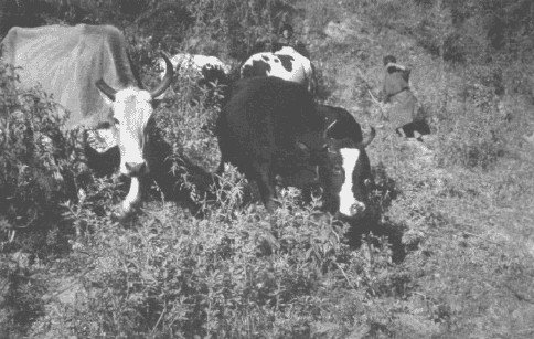
An estimated 65 percent of households keep cattle, and many of the others have some small stock, such as pigs and poultry. Production of manure for the preparation of compost is the main objective of keeping cattle. Draught work and dairy products are secondary benefits. Pigs are a principal source of meat, where meat is consumed. Poultry are kept primarily for eggs. Small ruminants (sheep and goats) are rarely kept, and in fact raising them is not encouraged by the government.
Food crops are primarily produced for home consumption. More than 90 percent of all production is consumed in the villages as food or alcohol (Table 5). At household level, 30 - 50 percent of all food grains are converted to alcoholic beverages for home consumption.
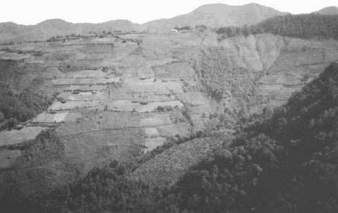
The terrain is composed of deep gorges and narrow valleys that provide limited opportunities for irrigated land use. Except for the limited valley bottom lands and natural table tops in the middle slopes, the majority of the permanently cultivated land is sloping dry land (rain-fed) where hill erosion is common. If the international norms for land use capability were to be applied to the district, most of this dry land would be recommended for alternative uses or for cultivation only after applying major conservation measures. A summary of crops, soils and land management practices is presented below.
PATTERN OF USE | ||
MAJOR FARM PRODUCE |
% CONSUMED |
% SOLD |
Maize |
100 |
- |
Buckwheat |
100 |
- |
Dairy products |
90 |
10 |
Beans, soya beans/peas |
80 |
20 |
Vegetables (mainly radish) |
50 |
50 |
Potato |
30 |
70 |
Chilies |
25 |
75 |
Fruit crops |
10 |
90 |
Wetland (chushing): Paddy rice is the major summer crop grown in wetland and the main winter crop is wheat; buckwheat, potatoes, maize, pulses and vegetables are also grown as minor winter crops. The terrace networks are well constructed although the maintenance is poor. Gravity irrigation drains from upper terraces down to the ones below, but there is hardly any provision for excess water drainage and uncontrolled movement of water has given rise to formation of gullies.
Rain-fed or dry land (kamshing): Maize is the major rain-fed summer crop, representing almost 62 percent of annual crops. Buckwheat is widely grown in areas too cold for maize. Wheat, barley, mustard, pulses, buckwheat, and potatoes are common winter crops in maize growing areas. Dry land is found all over the sloping areas in the district irrespective of the slope gradient and the soil depth. Slope gradient in the dry land varies from 0 to 65 percent and although the soil depth ranges from 10 to 90 cm, the depth of the topsoil is generally very shallow (5-8 cm) in spite of widespread composting. There are some situations where slopes exceeding 80 percent and soils of less than 10 cm depth are being converted into rain-fed cropland.
Intensive cropping, poor management practices and the fact that commercial fertilizers are not being used allow little buildup of organic matter. Soil sample tests indicated deficiency in nitrogen, fair to average potassium and very low phosphorous. Compost produced from farmyard manure, crop residue and leaves collected from forest areas is commonly used to fertilize the rain-fed fields. Cattle are coveted for their production of manure more than anything else, and when pigs are kept, that manure is also put into the compost pit. The land preparation standard in dry land is low and crop husbandry is also minimal. Due to the shortage of labour, farmers can afford one weeding at the most. Harvesting and post-harvesting operations are entirely manual.
Potential for the irrigation of dry lands is almost negligible. Less than 5 percent of the dry lands are terraced scientifically. While several years of cultivation have reduced the original natural slope, giving an appearance of outward sloping terraces, substantial erosion occurs during the pre-monsoon rains. The soil moisture content varies depending upon the application of mulch. Where humus and compost are applied regularly, the intensity of erosion seems surprisingly low. Recently, farmers have started contour bunding by placing branches and twigs and other plant matter in bundles along contours to arrest downhill soil movement. They have also started planting hedges for the dual functions of protection against grazing and reduction of erosion. Some of these hedge plants are also suitable for fodder.
Fruit orchards: Oranges at lower altitude and apples at the higher altitudes are the principal fruits grown. Fruit-trees are raised in terraces, which are more gentle than most of the dry land. Orchard terraces are better maintained and erosion problems are found to be minimal. Since all the orchard terraces are rain-fed, rainwater is a valuable input. However, optimum use of rainwater is lacking. The terraces are outward sloping and mulching is not practised so most of the rainwater is lost as overland flow. Fruit-trees are planted haphazardly and do not follow the contour lines. Tree husbandry, especially in the case of apples, has been observed to be very poor. Nutrient deficiency was observed in all the young and older fruit-trees throughout the district.
Tsheri land: The shifting cultivation areas of Pema Gatshel generally had very shallow topsoil, often with a texture of sandy loam to clay loam and slightly acid. Tsheri slopes are steep (l0-100 percent) and usually rocky on and below the surface. Other than the fallow period itself, forms of soil and water conservation on tsheri land are almost entirely absent. The fertility of the soil on tsheri land is positively correlated to the length of the fallow period. The absence of ploughing fortunately reduces the chances of water and wind erosion. Crops and land husbandry practices in tsheri land will be discussed in the next chapter.
Grazing land and animal husbandry practices: The extent of pastureland that is exclusively used for grazing is not known. The district land registration records state that Pema Gatshel has 408 ha of registered pastureland, and another 51 ha of land was brought under improved fodder production during the Fifth Plan, mainly in the tsheri area (MAH, 1987). Grazing land overlaps with forest in all blocks of Perna Gatshel district and the predominant use of forest land is for cattle grazing. The livestock population of Perna Gatshel district consists of about 6 700 cattle, 1100 horses or mules, 2 200 pigs and 4 400 poultry (DAH, 1986). Farmer interviews indicate that the animal population is increasing.
During the summer, cattle are grazed in the subalpine and temperate zones. In the winter cattle move down to the subtropical zone. Specific information on productivity in these grasslands is not available. Native pastures located near the villages are heavily grazed and productivity is very low. They have become merely a loitering grounds for cattle and the surface soil is very hard due to compaction. During heavy monsoon rains the excessive water flows trigger the formation of rills and gullies. Grassland conditions in the subalpine zone (beyond the borders of the district) have not deteriorated, but the condition of temperate grazing land is deteriorating due to continuous grazing in both seasons. In the subtropical zone, the grazing land is deteriorating at an even faster rate owing to the closeness to habitation, frequent fires and lesser grazing areas for the larger number of cattle.
