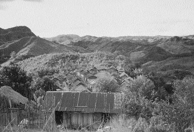
Photo 1: This is a view over the village of Anivorano showing cleared hillsides, once forested.
Community Forestry Case Study 10:
Tree and Land Tenure: Using Rapid Appraisal to Study Natural Resource Management: A case study from Anivorano, Madagascar
by Karen Schoonmaker Freudenberger
This case study illustrates how Rapid Rural Appraisal (RRA) can be used to study tenure and resource management issues. It offers just one example of how and why tenure research might be carried out. In this instance, the case study was part of a larger research effort to inform a policy debate in Madagascar on whether (and how) national land legislation should be amended to promote a more sustainable use of the country's resources. This was, in turn, part of a larger programme to devise policies consistent with Madagascar's Environmental Action Plan. In other situations, tenure research might be carried out to help a project better understand how to reinforce villagers' own resource management efforts or whether latent tenure conflicts risk jeopardizing a project's development activities.
This monograph complements earlier Community Forestry publications, particularly Rapid Appraisal of Tree and Land Tenure (Community Forestry Note 5) and Tree and Land Tenure: Rapid Appraisal Tools (Community Forestry Field Manual 4). All three publications emphasize that while there are methodological principles to be followed, there are no formulas for how to do Rapid Appraisal. Readers are asked, therefore, not to use this case as a model for what a Rapid Appraisal should look like, but rather to view it as an example of how the panoply of techniques that comprise the methodology can be combined in a systematic process to gather information on tenure and resource management.
Six chapters tell two stories in one. The first is the tale of how a team of Malagasy and U.S. researchers used RRA to study the complex tenure situation in one Malagasy village. This is the theme of chapters 2 and 3, which take the reader step-by-step through the process that was used to carry out an RRA in the village of Anivorano in June 1993. Chapter 2 discusses the preparations that were made before the team went to the field, and chapter 3 follows the fieldwork chronologically, walking the reader systematically through the activities that were carried out each day.
The second story is about what the team learned as it carried out these techniques in the field. This is the subject of chapters 4 and 5, which assemble the information obtained using different RRA tools into a story about resource management in a hillside village. Interactions between the customary and the state tenure systems are explored as the study attempts to understand the pressures that are leading to the rapid destruction of the forest in Anivorano. It is hoped that with the methodology used to collect the information presented side by side with the study's findings, the reader will get a better feel for RRA's potential to gather practical and usable information of this kind. The principal focus of the case study is on methodological issues, however, and so the last chapter steps back again to put the spotlight on RRA, addressing, in particular, the strengths and limitations of the methodology, using the Anivorano case study to illustrate some of the concerns that have been raised by both practitioners and critics.
Since the late 1980s, both the Government of Madagascar and the donor community have become increasingly concerned about the management of natural resources on the island, which is the fourth largest in the world. Madagascar has a unique ecosystem, host to an extraordinary richness of biological diversity, including nearly 8000 endemic species of flowering plants (Wright 1993). Nevertheless, much of the native vegetation has been lost as forests have been cleared, primarily for logging and agriculture. The diminishing forests of Madagascar are a concern to local people, to the national government and to the international community.
Locally, people's well-being is inextricably tied to the natural resource base, whether used as a source of food, medicines or fuel. Nationally, the government worries about such issues as the effects of deforestation on watersheds, changes in soil fertility that will affect the nation's ability to produce food and the impact on foreign exchange when export products, such as wood, are used up. International concerns focus on questions of the declining biodiversity as plant and animal niches are destroyed through the clearing of ancient forests. Many of Madagascar's plants are highly valued for medicinal purposes in the West as well as locally.
Concern with the declining resource base has led to increased efforts to understand the causes and consequences of forest clearing. Researchers are working to understand the incentives and motivations pushing people to cut forests. With this information, policy makers and development workers can think about how to change the incentives so that communities find it more advantageous to protect forests than to cut them. Information about a community's resource management systems is particularly needed when governments are considering policy changes (e.g. in land and forest codes) that are likely to have a major impact on the incentives and sanctions related to the use of resources. Without understanding the rationale behind local practices, the policy changes may have unintended and even counterproductive effects.
A potential example of such a "backward incentive" was noted in this study. Often people assume, for example, that formal, government-supervised titling of individual land parcels will increase the holder's tenure security. It is supposed that this will, in turn, lead the titled owner to invest and intensify production on agricultural lands, thereby diminishing the practice of more extensive production practices, which put pressure on forests. With the encouragement of some donors, titling is now being considered in Madagascar, and pilot titling programmes have actually begun in some areas. By looking carefully at existing tenure systems and resource-management practices, this study was able to predict that titling of private land-at least in this particular community-was very likely to produce just the opposite effect and lead to even more rapid clearing of the remaining forested area. The reasons for this are discussed in chapter 5.
As Madagascar continues to debate environmental policy reforms, research at many levels has an important role to play in informing the discussion. The case study presented here was part of a larger research project1 investigating land and resource tenure issues and their relationship to natural resource management practices and the conservation of biodiversity in and around Madagascar's protected areas. In addition to this case study village, seven other sites are being studied in order to understand the perspectives and practices of local resource users in different areas of the country. The information gathered from these studies will be discussed in national policy workshops as questions of titling and other resource management policies are reviewed. As ministry officials, representatives of international pharmaceutical companies, wildlife experts, donors and development workers debate these issues, research from RRAs such as this one will help to ensure that the views and concerns of village people are also represented in the debate.
A wide variety of methods can be used to conduct research under diverse conditions in order to meet different objectives. These include highly quantitative techniques, such as survey methods, as well as more qualitative approaches, including anthropological studies. Among the more recent additions to the family of research methodologies are the "participatory" methods, such as Rapid Rural Appraisal (RRA) and Participatory Rural Appraisal (PRA). The former is most often used by outsiders conducting research in an area, while the latter is more commonly used by local people, sometimes in conjunction with outsiders, conducting research for their own planning purposes.
Every research method, whether quantitative or qualitative, has strengths and weaknesses. The key to getting the best results lies, therefore, in choosing the method best suited to the type of information sought and to the conditions in which the information will be gathered, analysed and used. Often, because different methods are suited to different uses and conditions, it makes sense to combine several methods, using each where it is most appropriate. In the year-long research study (of which this case is just one part) several methods were combined.2 In each of the seven sites studied, at least three research methods were used. In each village, or group of villages, an RRA3 was first conducted. These RRAs typically lasted 7-10 days and provided a core around which other activities took place. (The total time spent in each village was 14-21 days.) In addition to gathering highly useful information, during the RRA the research team built a rapport with the community which facilitated the other research activities.
What is RRA?Rapid Rural Appraisal is a qualitative, participatory research methodology, most often used to gather and analyse information in rural communities. In RRA, multidisciplinary teams of researchers from different backgrounds conduct studies of carefully defined issues, generally in short, intensive field studies. RRA uses a variety of tools and techniques to gather information. All its tools are designed to promote the participation of local people in both the collection and the analysis of information. The tools approach questions from different angles, however. Some are particularly helpful in addressing spatial issues, some gather more temporal information, and others help local people to analyse their situation by ranking issues or problems. Just as care is needed when matching a research methodology to the kind of study being done, so within RRA the most appropriate tool is selected for each type of information needed to meet the study's objectives. RRA insists that diverse perspectives should be explored within the community studied. Villages, like other communities, represent many diverse interests depending on gender, social and economic standing, sources of livelihood, etc. It is important that the views of different groups and interests be explored in order to fully understand issues as complex as resource use patterns in a community. In short, the RRA method requires that a diverse group of researchers use a diverse set of tools to explore the diverse views and experiences of a community. This diversification of perspectives at the level of the researcher, the informant and the means of communication which links them together is called triangulation. Triangulation is a core principle of RRA because, on the one hand, it is the primary strategy used to avoid bias in the research results and, on the other hand, it considerably enriches the quality of the data collected. |
Following the RRA, a brief survey was conducted and questionnaires were administered to 30 randomly selected households in the community. Geo-reference points were also taken in each study area to tie the qualitative information to specific latitude and longitude points and to facilitate future monitoring of changes in the vegetative cover. In addition to these methods, follow-up focus groups and more in-depth interviews were carried out on topics identified as issues of particular importance in the RRA and secondary information was collected from a wide variety of sources.
This combination of methodologies permitted the team to use each method where it was the strongest. RRA, for example, is excellent at getting rich qualitative information and encourages the researcher to respond to local concerns and adapt the approach to local issues. It creates a rapport with the village that allows more delicate and controversial subjects to be broached in a sensitive and non-confrontational way. It is also particularly effective at probing deeply in order to understand why certain practices are followed and to explore the logic behind those practices. These are areas where questionnaires, which are often limited to close-ended responses, often cannot elicit good information.
RRA is not so effective, however, at gathering standardized information that can be systematically compared across communities or at different time intervals. This is where quantitative techniques-surveys for social science information and geo-referencing for monitoring the vegetative cover-can complement the qualitative and participatory approaches. The surveys assure that a certain core set of issues are approached in a way that permits systematic comparison of all the sites that comprise the data set.
This monograph presents a case study of a single Rapid Rural Appraisal. This RRA was the first activity in the year-long research project described above and preceded the research in the seven sites that were chosen later for more complete analysis. This initial RRA was carried out so that the team could practise RRA techniques and clarify the objectives and working hypotheses it would use during the remainder of the study. In the actual case reported here, then, RRA was used by itself and not in conjunction with either surveys or geo-referencing as would follow in the remaining sites of the study.
In the case study, the reader will find out first what the team had to do to prepare for the field study and then how diverse tools were used to gather different pieces of information that eventually fit together into a kind of jigsaw puzzle of tenure and resource management in the study village. In the resulting picture, the key issues confronting local resource management are clearly discernible.
Before the actual visit to the village for the field research in an RRA study, there are several preliminary steps that are critical to the success of the endeavour. These include setting clear guiding objectives that will orient the team's activities in the field, selecting the research team and identifying the site where the study will take place. In the particular study illustrated by this case, two teams of people went to two neighbouring villages. This was done in part to have a larger sample and in part to enable more people to be trained in the methodology. Since the activities and results of the two studies were very similar, only the case from the village of Anivorano will be reported on here.
In RRA, a key consideration in selecting members of the team is ensuring that the researchers bring diverse perspectives to the study. This is important for triangulation.1 Every person on a team has certain characteristics that make him or her, on the one hand, more perceptive to some kinds of information and, on the other, less adept at picking up other kinds of information. This can lead to biases in the information that is collected. For example, a team of only men may, without even thinking about it, put more emphasis on looking at how men use resources than what women do. A group composed only of social scientists may not even notice certain patterns, such as the absence of younger trees, that would indicate a problem with resource regeneration. Because of this, RRA makes a special effort to combine individuals with different backgrounds, training and skills on the same team. This helps both to neutralize the biases of individual members and to enrich the information that is collected.
The members of this particular team were selected in order to triangulate several factors. There was concern that the team reflect a gender balance, that not all members of the team come from the same ethnic group, that various social sciences and technical disciplines be represented and that at least some members of the team have prior experience using RRA and/or looking at tenure issues. As it turned out, although it was not a priority in selection, there was also an interesting age diversity since one of the team members was near retirement. It helped to have an "elder" among the team members.
The final selection of team members included people with the following characteristics:
In addition, a nanny accompanied the team to care for the team leader's year-old daughter. This duo proved a great help in facilitating the team's integration into village life and establishing the rapport between researchers and villagers that so enriched the findings of this study.
One of the first steps in an RRA study is setting the objectives for the research. The objectives focus the activities of the team and guide their questions so that at the end of the time in the field, they have spent the most time on the issues of greatest concern and have not wasted time looking at questions that have little relevance to the study. There is a caveat to this, however. The objectives are generally set by the research team before they ever arrive in the village. There may be issues raised by the community during the course of the research that do not figure in the original objectives. If the team, on careful reflection, believes these are relevant to the study at hand, they may amend or expand the objectives to include these concerns.
In this case, a preliminary draft of the objectives was prepared by a subgroup of the team that had particular experience in tenure and resource management issues. The subgroup reviewed objectives that had been used in similar studies elsewhere and looked at secondary information from Madagascar in order to identify issues that seemed relevant. They then proposed these draft objectives to the team, which had a chance to consider and revise them in a meeting before going to the field.
Before leaving for the village, the team agreed upon the following:
Theme: Study on Tenure and the Management of Natural Resources
General Guidelines Concerning all the Objectives:
Objectives of the study on Tenure and the Management of Natural ResourcesObjective 1:Describe the territory, taking into consideration the following questions:
Objective 2:Identify how the resources defined above (I) are used, with particular attention to the following questions:
Objective 3:Analyse how the community's resources are managed and who has (a) rights, (b) responsibilities and (c) decision-making authority for each of the following resources: land; forests, trees and their products, water, fauna, other.
Objective 4:Determine the mechanisms for the resolution of conflicts around natural resources.
|
Additional Objectives for a Future Study:
Although the team did not include it among the objectives, it did gather considerable background information on the community studied in order to provide a context for the more focused resource management questions. In a future study, it would be useful to make this objective more explicit, adding a first objective:
In addition, since the final report must include a synthesis of the findings, it makes sense to be explicit about this in the objectives as well. Hence, a final objective might be:
This case study was a first effort at training team members and testing the methodology that would be followed in subsequent sites where resource management arrangements around national parks were to be studied. For a number of reasons relating to time and distance, it was not possible to choose a site very near a park for this preliminary study, so the team chose villages adjacent to classified forest areas as sites that would face similar issues. Two forest areas within a day's drive of the capital, Antananarivo, were identified. By talking to project and government personnel who worked in both forests, the team was able to narrow its focus to one of the forests where questions of resource management were more controversial and potentially more interesting to study. In addition, the project working in the area was very interested in gaining information from the studies to improve its interventions in the area. The team considered this a high recommendation for the site, since the information would find some immediate use and could potentially benefit the populations participating in the study.
In the next step, detailed maps were used to identify the villages that have land around the classified forest. Project team members then went back and discussed specific villages with government foresters and project staff who knew the area well. The purpose of these discussions was to obtain a short-list of five or six villages that could be considered "representative" of the area. Villages that were unusually small, that were composed of an ethnic group that is rare in the area, or that were known to have serious internal conflicts were eliminated from consideration at this stage.
Having narrowed the list to five potential villages, during the week before the study was to take place the team sent two researchers and the translator to the villages themselves to gather information that the team could use in its site selection. The advance team visited all five villages, spoke in some detail to village leaders about the purpose of the study and how it would be carried out, inquired about their interest in participating and assessed whether the village was logistically prepared to receive a team of seven people for a week. By briefly discussing questions of resource use and management, the visitors were also able to get a sense of the issues that concerned the villagers. The village leaders were told that since, regrettably, the team could not visit all five villages, a choice of only two would have to be made. They would receive word within the next three days on whether the study would take place in their village and those selected would receive information on the arrival of the teams.
On the return of the advance party the team met and, from the information gathered in these preliminary visits, chose two villages for the study. The villages selected were Anivorano (the subject of this report) and Ambodigavo. Both were Betsimisaraka villages with populations of 300-500 people, well off the main road and adjacent to the Classified Forest of Ankeniheny.
The team met several times before it left for the field to review methodological issues. Secondary materials on tenure and the area to be visited were distributed among the researchers, and a day was set aside to discuss the literature and to think about issues that might arise in the field. The team carefully planned its arrival in the villages, deciding who would be responsible for the initial protocol speeches and discussing what message should be transmitted. The team also decided who would launch the first activity that would be carried out with the population (preparation of a village map) and drew up a checklist of issues to be covered.
A subgroup of the team was responsible for logistical preparations. In the preparatory visits to the village, the team emissaries had explained that the researchers would prefer to stay in the village and integrate as much as possible into the daily life of the community. The village leaders were asked whether they could suggest a place, or places, where the team members might stay, either a village house or a communal facility, such as a church or school. In Anivorano, the village offered two one-room houses, one for the women and one for the men. The team logisticians assembled enough mattresses, flashlights, bath buckets and other essentials as needed for a village stay. They also bought basic foodstuffs, which were given to the women in the village who had agreed to supervise the cooking during the team's stay. These women prepared the meals each day and were compensated for their services.
These preparations for the field study were carried out over a two-week period. By the end, the teams were ready and eager to begin the fieldwork, as will be described in the next chapter.
Every RRA comprises a period of preparation for the field study, a period of research in the field and a period of analysis and write-up of the information. The activities of the Anivorano RRA from preparation to write-up are summarized in figure 1. This chapter focuses on the middle box: activities in the field. The fieldwork in an RRA typically lasts from four to 10 days. During this time, the research team lives in the village (or villages) where the study is taking place and uses a variety of tools and techniques to gather information. Each bit of information is like a puzzle piece. As more information is gathered, the pieces begin to fit together to make a coherent picture inside the frame established by the objectives at the outset. While the fieldwork is often done during a single block of time, this is not always the case. The programme of the researchers or the villagers may determine a better schedule, such as three successive weekends of research. It does not matter how the fieldwork is timed as long as the essential methodological principles of RRA (e.g., setting clear objectives and the triangulation of team members, tools and informants) are rigorously followed.
The field research for this RRA lasted seven days; the first and last days were abbreviated because the drive to and from Antananarivo took several hours. Following a brief introduction containing information relevant to all the techniques used, the team's activities are described in detail in the following pages in the order in which they actually took place.
| PRELIMINARY ACTIVITIES | |
|---|---|
|
|
| ACTIVITIES IN THE FIELD | |
Day 1
Day 2
Day 3
Day 4
|
Day 5
Day 6
Day 7
SSI semi-structured interview |
| AFTER THE FIELDWORK | |
|
|
Figure 1: Overview of activities for Anivorano RRA on tenure and natural resource management .
Although detailed information on the village of Anivorano will be provided in chapters 4 and 5, the reader may wish to know a bit about the village in order to put the activities that follow in some context. Anivorano is a village of about 300 people, all of whom (with the exception of a very few recent arrivals) belong to the Betsimisaraka ethnic group. The livelihood of the villagers is oriented primarily around agriculture, and particularly the production of rice on steep hillside slopes around the village. The villagers live in small, usually one-room wooden houses built on short stilts to keep them dry. Many villagers wear clothing made of the area's characteristic cloth woven of reeds. Signs of traditional religious practices, such as remains from animal sacrifices, are seen throughout the village. A small school constructed of corrugated metal sheets perches near the church on a hill overlooking the village; the village water supply is obtained from a spring that surfaces near the school. Access to the village is by a winding laterite road that hugs the hillsides and becomes impassable during certain times in the rainy season. This is about as much as the RRA team knew about Anivorano as it pulled into the village on a bright sunny Thursday afternoon, ready to begin a lively week of field activities.
Good RRAs exude relaxation and flexibility. This does not mean, however, that they are sloppy or haphazard. On the contrary, no one can be relaxed who does not feel well prepared or is in a panic because the information being gathered seems incoherent. There are several procedures that are critical to ensuring that RRA's various activities are well prepared and that the information obtained is at least partially digested as the team progresses so as to avoid total confusion. These include carefully preparing an interview guide for each activity and spending the time to review each tool and discuss the findings as a group.
Before carrying out each of the activities reported in this chapter, the team met as a group to prepare a checklist (interview guide) of the issues to be covered in that session. This is an important step because RRA does not use preestablished questionnaires. Instead, the researchers follow question guides which orient the direction of the interview or activity but allow enough flexibility and open-endedness to ensure that villagers' concerns and perspectives shine clearly through. If interview guides are not prepared, or are too vague, the resulting information tends to be scattered and unsystematic. When this happens, it is often very difficult to assemble a coherent picture at the end of the fieldwork. If the guide is too focused, or if it is followed too rigidly, the team may fail to follow up on interesting and surprising avenues of inquiry. In such cases, the final picture risks reflecting the team's preconceived notions. Hence, there is a balance to be struck in preparing and following checklists.
Photo 1: This is a view over the village of Anivorano showing cleared hillsides, once forested.
Some of the activities were carried out by the whole team, with a group of village informants. In others, the team divided up and carried out different activities. Often this would involve doing the same matrix, or interviewing on the same topic, but with different groups of villagers. For example, one group might talk to women, while another met with men. This made possible a greater triangulation of perspectives and ensured that diverse viewpoints were represented throughout the research.
After each activity, the team met again to review what it had learned. If the team had split into subgroups, the researchers who had conducted the exercise first met together and noted the most important information that they had learned on a sheet of flipchart paper. They then shared the information with the rest of the team. If the whole team performed the activity together, it met as a group to prepare the flipchart of salient points. This "digesting" and sharing of information was time-consuming, but the team felt that it was well worth the time spent. As the information-gathering progressed, the teams noted where information had been triangulated by putting a red triangle next to information that had been cross-checked. Inconsistencies were marked with a green question mark so that the team would remember to pursue those issues further. By systematically reviewing the information as it was collected, the team was better able to prepare the next day's tools. Furthermore, the availability of flipcharts summarizing each interview greatly facilitated the analysis of information at the end of the study.
At some point each day, the team held an "interaction" meeting (usually in conjunction with the sharing of information), when it focused on methodological questions. During this time the team would review all the activities of the day and consider whether there had been problems with the comportment of team members or the use of the tools that could be corrected. It also thought about whether any biases had begun to creep into the study and considered what might be done to overcome those biases. Finally, it planned the activities for the next day, deciding what issues would be addressed, what tool was best suited for looking at those issues and to whom the activity should be oriented. At this point, the team prepared the checklist for the activity and selected one person to be the "presenter".
These interaction meetings often took as long as two hours, especially if there was information to be shared among different groups that had performed parallel activities during the day.
In this section a report of each day's activities is presented with a brief description of the techniques used and some of the most interesting information that resulted from the activity. The summary of findings is purely indicative; it does not attempt to summarize all the information collected and it avoids, for the most part, repeating when the same information was collected by multiple techniques. The reader should remember, however, that the repetition of information from different sources and using different techniques is essential to triangulation.
| DAY 1 | |
|---|---|
| Morning: |
|
| Afternoon: |
|
Activity: Protocol meeting with village
By whom: Whole team
With whom: The village elders and a cross-section of the village inhabitants (approx. 40 people)
Description: The protocol meeting was held in the village square, where it was accessible to anyone who was interested. The purpose of the meeting was to explain the purpose of the research so that the community would feel it had a stake in the research process.
The team explained carefully how the results of this and other studies would be used to inform a national policy dialogue on tenure and natural resource issues. The presenter noted that thanks to their taking the time to understand the situation of villagers like those in Anivorano, there was a greater chance that the villagers' concerns, and not just the views of the more rich and more powerful, would be represented in the debate. The team stated explicitly that the research was unlikely to lead to any immediate changes that would help the village in the short-run. Rather, the information gained would help in drafting laws that were more appropriate to the concerns of villagers like themselves.1
In addition to this discussion, the following points were covered in the protocol meeting. (Since the elders of the village had already heard much of this information on the occasion of the earlier visit to prepare the RRA, they were able to contribute to the explanations in many cases.)
Team Introduction. Each researcher introduced him/herself, including some personal information about family or interests (to try to "humanize" the team) and explained his or her particular research concern (to preview the kinds of questions that would be asked). A woman on the team mentioned, for example, that she had a special interest in how village women use and manage resources and would therefore be interested in talking to women about these questions and would like, if possible, in accompanying them to their fields.
Selection of the village. The selection of the village was explained, along with the concept of sampling. The idea that the team had "drawn the names of the villages from a hat" was presented to reassure the population that there was no negative reason that they had been selected and that it might as easily have been the village next door. This explanation was used to reinforce the message that the accuracy of the information was important since the results of the study would help in understanding not only their specific situation but also the issues facing other villages in similar settings.
Programme for the week. The general programme for the stay in the village was outlined (though it was not possible at this point to specify the exact programme for any given day). There was special mention that on the last day, before the team's departure, it would present the results of its findings so that everyone would have a chance to find out what the team had done and to correct or add any information as necessary. Once again, the notion of sampling was discussed in order to explain that the team would be performing different activities with various groups of people but that all the information would be brought together at the end. The team particularly emphasized the importance of getting the views of all different kinds of people in the community.
Confidentiality. Throughout the meeting, the team assured the villagers that nothing they told the researchers could bring them any harm and that the identities of individuals would not appear in any written documents or reports.
Activity: Participatory village and territory mapping
By whom : Whole team
With whom: All the villagers who had been at the protocol meeting and others who drifted in
Description: Since a large group of people had assembled for the protocol meeting, this provided the perfect opportunity to make a participatory village map. The map had several purposes. Among these were:
The team had decided to focus at first on obtaining information on the central, inhabited part of the village. This included locating important sites, including village infrastructures, homes of village leaders, other landmarks, water sources and others. Then, if time permitted, it would expand the area of inquiry to ask about the territorial limits of the village, uses of space, the origins of the boundaries, relations with neighbouring villages and more.
Principal findings
The map-making was a lively activity, with many different people contributing information and helping to draw the boundaries and identify landmarks. Because the central inhabited village is only used for a few months of the year (the rest of the time people live in houses they construct in their fields), the map rather quickly expanded to include all the lands that the village considers to be theirs (the "territory"). Among the key pieces of information that came out in making the map were the following:
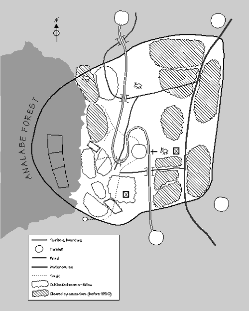
The team made this map in collaboration with a large group of villagers seated on the ground in the village square. The outlines were drawn with a stick in the dirt, and stones, leaves and other objects were used to indicate important landmarks. Information about the dates when different parcels were cleared was gathered in a later activity (see day 6).
Activity: Guided village visit
By whom: Whole team (divided into three subgroups)
With whom: Three village guides
Description: By the time the map was completed, it was late afternoon. Most people needed to return home to take care of animals, prepare the evening meal and collect water. The team members were eager to get to know their adopted village a bit better, however. Dividing into groups of two, each pair asked someone with whom they had become friendly during the mapping exercise to show them the village and introduce them to people they met along the way. This made it possible to make contacts with people who had not been able to attend the formal introduction, helped to develop a rapport with both the guides and the people encountered on the route, and-although it was entirely informal-gathered considerable information about village social structure, history, customs and economic activity.
Activity: Team interaction
By whom: Whole team (moderated by the team leader)
Description: After dinner, the team met briefly to review how things had gone during the day, to share the information from our village visits and to prepare the checklist for the transect that was to be carried out the next morning. Minor difficulties that had arisen during the day (e.g., some team members had tended to ask leading questions during the mapping activity) were discussed, and corrective measures were suggested.
| DAY 2 | |
|---|---|
| Morning: |
|
| Afternoon: |
|
Activity: Transect walk
By whom: Whole team (divided into 3 subgroups)
With whom: Three men and one woman guide
Description: A transect is a guided walk across the full territory that permits the team to ask questions as it passes through different micro-ecological zones. To do this transect the team divided into three subgroups with two researchers in each group. Each group had a different theme: one group looked particularly at trees and forests, the second focused on land and agriculture, and the third investigated animals and livestock. Each group developed a checklist with questions relating to its theme. Since the team wanted to look at the interaction among all of these factors, it was expected (and desired) that there would be substantial overlap between the information gathered by the different groups. In this way some information could be triangulated from several different perspectives.
The day before, just after the mapping exercise, the team had discussed the upcoming transect with the participants and asked for "specialist guides", with particular knowledge of trees, agriculture, or livestock to accompany the team members on their walk. Three men and a woman had been selected by the villagers and they were on the team's doorstep by 7:30 on the morning of the transect. Each subgroup set off in a different direction, depending on where the guide proposed as the most interesting for their topic, but each was determined to reach the edge of the territory in whatever direction they walked.
Principal findings
The nature of the terrain made the transect something of a physical feat. The fact that each of the groups persisted to the territorial boundaries, through gullies and over hilltops, substantially increased the villagers' respect for their urban visitors. In spite (or perhaps because) of the difficulty of the hike, the groups came back with a wealth of information. As expected, there were many areas of overlap where information could be cross-checked by the different groups. In a few areas, the teams found contradictions and noted them so that the issue could be pursued further. The team forester, who had the best technical grasp of these issues, drew the transect diagram from information shared by the subgroups after the walk.2
The following summarizes a small portion of the rich information gathered during the transect walk:
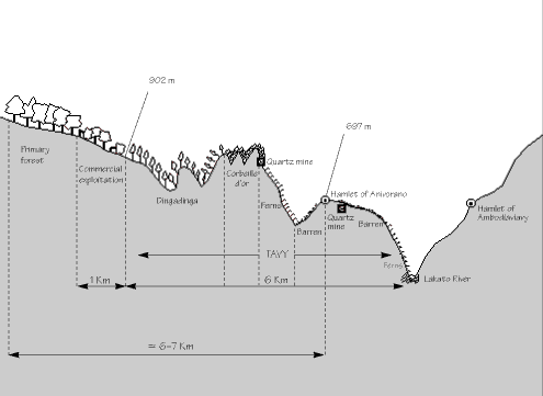
This transect was drawn by the team forester following the transect walk when three subgroups of researchers went out in different directions with village guides to the edge of the territory. More descriptive information from the walk was compiled on flipcharts.
Activity: Semi-structured interviews with local administrators
By whom: One member of the Anivorano team and a representative of the RRA team that was studying the neighbouring village of Ambodigavo
With whom: Local (firaisana) government official
Description: During the time that the rest of the team was engaged in the transect one member went to the local administrative centre to interview the government official there. This purpose of this activity was two-fold: to gather information and to explain, again, the purpose of the study and the teams' activities in the firaisana (rural community). (These officials had already been contacted during the preliminary site visits.) The interview gathered information about the local administrators' views on land use in the villages, their role in encouraging or discouraging commercial exploitation of wood, their knowledge of tenure conflicts in the area and their role in resource management and conflict resolution. In addition, the interviewers discussed broader resource management issues in the administrative zone and tried to determine whether issues arising in the villages being studied could be considered "typical" of the area as a whole.
Activity: Team interaction
By whom: Whole team
Description: Once the groups had a chance to recuperate from their transect walk and had worked on their individual summaries of findings, a team meeting was held at the end of the afternoon to share experiences, consider where the information was leading, identify points that cross-checked or contradicted one another, and plan the next day's activities.
| DAY 3 | |
|---|---|
| Morning: |
|
| Afternoon: |
|
Activity: Semi-structured interview
By whom: Two team members
With whom: Commercial woodcutter
Description A chance early morning encounter with one of the three commercial woodcutters with permits to exploit the forest in Anivorano resulted in an impromptu semi-structured interview. Information was gathered about the people holding permits, some of the principal problems encountered by the woodcutters and how the forest is divided among the exploiters. While superficial, this information was at least helpful in assisting the team to prepare for more in-depth interviews that would take place later in the study.
Activity: Venn diagram
By whom: Whole team
With whom: Three men, one woman elder
Description: An appointment had been set for early on the third day to meet with four leading members of the village to do a Venn diagram. Three men and one older woman were waiting when the team got to the village meeting place. One team member began by explaining the purpose of the diagram. The respondents answered that they thought the activity was a useful one but that before talking about such issues it was only appropriate that all present should drink to the honor of the ancestors. The team leader quickly sent out for a bottle of rum and the meeting was appropriately inaugurated. (The team soon decided that it was prudent always to have a bottle of rum on hand since, as it turned out, a great many activities touched on subjects such as village history that entered the domain of the ancestors and therefore proceeded more smoothly when anointedÉ)
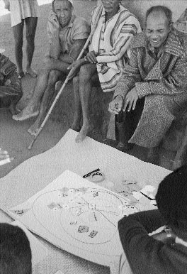
Photo 2: Villagers constructing a Venn diagram to show how village institutions interact with outside organizations.
Principal findings
The Venn diagram placed Anivorano in the context of the fokonolona (collection of villages sharing common roots) to which it belongs. Seven villages comprise the fokonolona and the Venn diagram clearly indicated the linkages between the various villages. Both traditional and modern administrative structures bring representatives from the seven villages together. Once the diagram was completed, the session evolved into a semi-structured interview on land rules and rights of ownership and use, using the diagram to indicate who makes decisions under different circumstances.
Among the key findings of the Venn diagram:
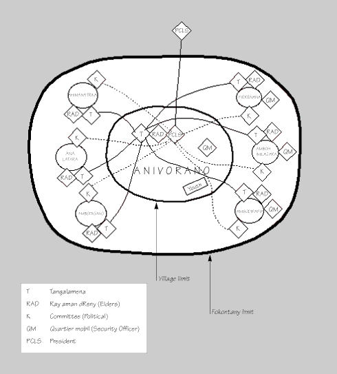
The Venn diagram was done with a group of village notables in the town square on a large sheet of flipchart paper laid on the ground. Papers of various colours and shapes were stuck on the flipchart to represent different institutions. The village of Anivorano is represented in the large circle at the centre of the diagram. Within Anivorano, the four principal authorities are represented by diamond shapes. Since the Tangalamena and President are both members of the Ray aman dReny (Elders), the diamonds overlap. In the larger circle outside the village limit but still inside the fokontany the six other villages are represented, each with their own leaders. The lines between the Tangalamena of the various villages indicate that decisions are often made in consultation. The group of Tangalamena is presided by the leader from Anivorano. Similarly, the President (PCLS) maintains contacts with the political committees of the other six villages, as indicated by the broken lines. He also reports to the PDS, a higher administrative authority based outside the fokontany.
Activity: Wealth ranking
By whom: Whole team
With whom: Two young men of village
Description: The team decided to do a wealth ranking, using cards with the names of each head of household, after lunch. One of the younger men of the village, who had already been helpful on several occasions and was generally friendly with the team, was invited to eat lunch with the team and then to respond to the wealth ranking afterwards. He brought a friend along. One of the team members had already obtained a list of the names and had prepared the cards.
After discussing his ideas of what "wealth" means in the community (principally cattle and land sufficient to feed the family), the respondent divided the cards into four piles. Later, a team member organized the information into the histogram in diagram 4, showing what proportion of the village falls into each group and the characteristics of the different wealth categories.
Principal findings
Among the key findings of the activity were the following:
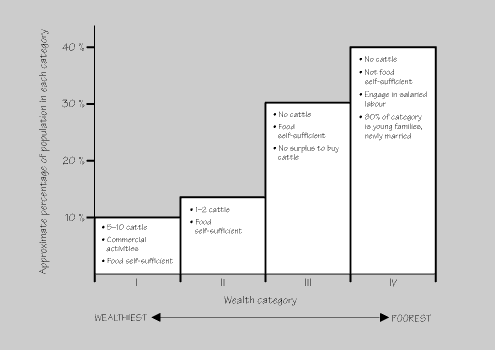
First, cards bearing the names of each head of household were prepared. After discussing what "wealth" means, the informant put the cards in different piles so that all the families in a pile had approximately the same level of wealth. This diagram was later drawn by the team to summarize the information from the card piles.
Activity: Team interaction
By whom: Whole team
Description: Later in afternoon, the team had a meeting to review the findings of the wealth ranking and the Venn diagram. The group was pleased to find that many points had already-on only the third day-been triangulated thanks to using different tools and talking with different informants. Information about mechanisms for the distribution of land in the community, for example, had been cross-checked and complementary information had been gathered in the map, transect, Venn diagram and wealth ranking. With each activity, the team's understanding of the rules concerning land allocation and their significance increased, enabling the researchers to ask more focused and pertinent questions as the study progressed. On the question of bias, there was some concern that certain village leaders had begun to dominate the activities. The team decided to put more effort into ensuring full participation of a wider range of villagers. One strategy for doing this was to move activities away from the central square and to do them instead with selected families or smaller groups in more out of the way places.
Activity: Semi-structured interview
By whom: Four team members
With whom: President of the youth group
Description: After dinner, several members of the team went to play cards with the President of the youth group. They had prepared a list of topics they wanted to discuss with him, but decided not to conduct a formal interview where information would be noted as they went along. Instead they discussed, played, joked and talked about many subjects including most of the ones on the checklist. Afterward they wrote down the information that was pertinent to the study.
Principal findings
Several important issues not previously covered by research activities surfaced in this informal gathering focused on youth concerns.
| DAY 4 | |
|---|---|
| Morning: |
|
| Afternoon: |
|
Activities: Semi-structured interviews (4)
By whom: Team members (divided into groups of two to three)
With whom:
Description: The fourth day of the RRA in Anivorano fell on a Sunday. Since some members of the village attend church and others do not, it was decided not to schedule any large group activities, but rather to divide the team into subgroups and to pursue some of the more focused questions that had arisen out of previous activities. One group attended the village church service, after which they interviewed the church leader and members of the congregation. Another interview with the security officer triangulated information gathered in the Venn diagram. One group spent the morning with the women who did the cooking for the team and was able to gather information on women's rights to land and other resources. In the early afternoon, a historical profile was done with several elderly villagers. This was not a detailed historical interview, but rather a chance to identify major periods in the history of natural resource management in the community. This information was needed to prepare the historical matrix that would be completed later in the day.
Activity: Historical matrix
By whom: Whole team
With whom: Large mixed group of villagers
Description: The purpose of a historical matrix is to see how certain factors have changed over time and to try to understand how communities adapt their strategies and activities to changing circumstances. This matrix was traced on paper, with five historical periods (ranging from the era before the revolution of 1947 to the present) along the horizontal axis. The vertical axis had 13 variables that were derived from previous discussions. These were either indicators of how resource availability and use have changed or indicators of the impact of those changes on the well-being of the community.
The historical matrix was slow to get started. People drifted in and the team became worried that if it began too late, participants would leave for the evening meal before the activity was completed. As it turned out, it was necessary to bring lanterns to complete the matrix, but this did not deter participation. People found the process so interesting that not a single person left, and in fact many more people joined the group as the discussion became more animated.
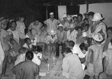
Photo 3: While doing a historical matrix villagers are identifying events which show how use of resources has changed.
Principal findings
The historical matrix (diagram 5) clearly showed the pressures of increasing population (and food cultivation needed to support that population) on a fixed land base. In addition the following trends were clearly noted:
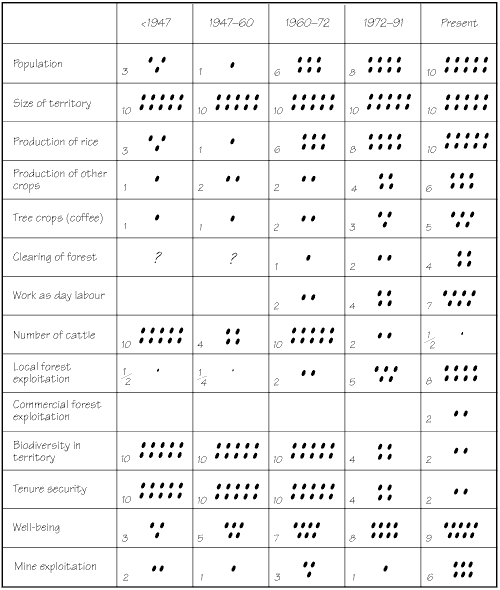
The historical matrix was drawn on a large sheet of paper on the ground in the central square. Room was left at the bottom so that respondents could add additional variables. They added the mine exploitation category. Symbols or pictures were drawn next to each variable to assist the illiterate. The matrix was completed vertically (completing one time period before starting the next), with the villagers placing beans in each square to indicate the importance of each variable during the time period in question. In almost all cases, the respondents came to a consensus on how many beans should be placed in each box. This was not the case concerning well-being, which provoked a major argument. The team members noted the diverging points of view even though only one viewpoint showed up on the matrix.
| DAY 5 | |
|---|---|
| Morning: |
|
| Afternoon: |
|
Activity: Preliminary analysis
By whom: Whole team
Description: On the morning of the fifth day, the team scheduled no information gathering activities, but instead took time out to reflect on where it was in the research process. This involved, first, sharing information from activities that had not been done as a group and had not yet been fully processed. Then the team reviewed each of the objectives in turn, noting the most significant findings on flipcharts. Lists were also started to note areas where the team felt that information was missing and where information was contradictory or unclear. The team took particular pains to review whom their informants had been during the first four days so that if there were any biases they could compensate in the last activities. While no acute imbalances were noted, the team did decide to orient some more sessions towards women and to ensure that at least a couple of the interviews took place with families that had been identified as among the poorest in the wealth ranking.
In light of this careful reflection, the team sketched out a programme of activities for the last two and a half days in the village. Having identified the issues still to be addressed, it considered which tools would be most effective at getting the information. It then chose the participants for each activity in light of its review of possible informant biases.
Activity: Two semi-structured interviews
By whom: Team (divided in two groups)
With whom:
Description: Semi-structured interviews were carried out with a poorer couple and with two older women, primarily to triangulate information on resource use and tenure rights that had been gathered in earlier activities. This enabled the team to find out what happens to widows, how resources are shared within families and what happens when landholders leave the community.
Activity: Family economy matrix
By whom: Team (divided into two groups)
With whom:
Description: The team had by now identified the various forms of resource use in the community but felt that it was still unclear about the relative importance of those activities. This information was needed to understand what factors were driving the overall exploitation of resources, and particularly the clearing of new lands in the forest. It decided to do a family economy matrix with several different families to get a better sense of the importance of different elements of the household economy. The matrix showed different elements of the household economy on the vertical axis. On the horizontal axis, it then compared the importance or each activity according to whether it was consumed by the family or sold. Each family also estimated, overall, the relative importance of each activity in its livelihood.
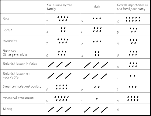
Family economy matrices were done with several families, including one that had been identified in the wealth ranking as among the poorest. This is the example from one family. The matrices were drawn on flipchart paper, leaving room for each family to add additional variables. First, the first two columns were completed horizontally, as the respondent compared whether the product was mostly sold or mostly consumed at home. When all the variables had been completed, the last column was completed vertically. The respondent was asked to compare the relative importance of each of the variables in the overall family economy.
Principal findings
Activity: Two semi-structured interviews
By whom: Team (divided into two groups)
With whom:
Description: One of the village shopkeepers had been outspoken in several of the group activities on environmental issues and his concern about the destruction of the village's forest reserve. Two members of the team interviewed him at length one evening in his shop and learned more about the history of the villagers' attempts to control commercial woodcutting and why they had largely been unsuccessful.
The team also made contact with a "poacher". This was one of the younger men of the village, who had cleared village forest land for his personal fields without following the norm, which requires a community decision before forest can be cleared. The interview explored the reasons why young people are pushed to clear forest lands, the sanctions they face and the frequency of the activity. This interview, like several of the previous ones with village youth, was conducted in a very informal setting and was interspersed with much joking and camaraderie. This was particularly important given the sensitivity of the topic.
| DAY 6 | |
|---|---|
| Morning: |
|
| Afternoon: |
|
Activity: Historical analysis of the territory map
By whom: Whole team
With whom: Group of elders, one woman, one youth
Description: The first day, when villagers drew the map on the ground, team members copied the map first into their notebooks and then onto a large sheet of flipchart paper. Since the map clearly indicated 16 different cultivation areas in the Anivorano territory, the team decided to use the map to explore deforestation patterns further. Working with the map, team members asked a group of more elderly informants to indicate when the different areas had been cut and to describe the circumstances surrounding the cutting. This led to an extremely interesting discussion that triangulated information previously collected in the Venn diagram, transect and other activities; it also added considerable new information and clarified several issues that had been unclear.
Principal findings
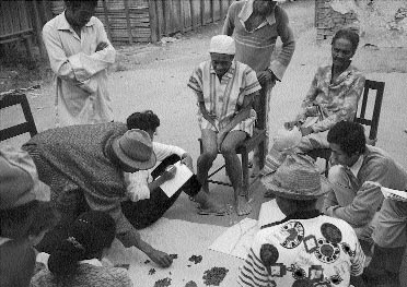
Photo 4: Bean quantification is being used to show the impact of the rice production cycle on soil quality.
Activity: Bean quantification of tavy cycles
By whom: Whole team
With whom: Same group as above
Description: The technique known as "bean quantification" can be used whenever researchers want to quantify (by rough proportions) the size or quantity of variables under discussion. In this case the technique was applied to understanding how much land of different soil qualities exists in the village territory. The historical mapping served as an excellent stimulus to a broader discussion of environmental issues, particularly soil degradation and the effects of deforestation. Team members always carried a small sack of beans to use as counters. In previous discussions they had learned that the village had a name for the most highly degraded soil. Taking a pile of beans to represent all the land of the village, they asked their informants to show what portion of the soil was the most severely degraded type. This done, they then asked what portion was the best-quality soil, which had another name that had been noted earlier by team members. Having launched the discussion with these simple questions (but having very little idea of where it all would lead), the team then sat back with astonishment as one of the informants said, "And let me show you what the rest of the soil of the territory is likeÉ". He proceeded to divide the remaining beans into seven different soil-quality types, each distinguished by the kind of plant that would regenerate there if the soil was left fallow.
Then, using the different piles of beans, he described the production system that causes the soil to degrade, starting with high-quality soil in the forest. He showed how over half a century, with 10 rice production cycles (each cycle comprising one rice crop and five years of fallow), the soil degrades to the poorest soil type. Soils of this type require a fallow period of more than 50 years to regenerate to the quality of soils found in secondary forests.

Diagrams 7 and 8 were drawn from information gathered in a semi-structured interview using bean quantification. First, a mound of beans was divided into piles of different sizes to show how different types of soil are distributed around the territory. The informants then described, by pointing at the bean piles, the process by which good soils degrade over time when rice is produced. The informant then reformulated the piles to show the amount of land of different quality 40 years ago. These diagrams were drawn by the team to summarize the information from the bean quantification exercise. They were later verified with the informants who had provided the initial information.
This diagram summarizes part of a discussion using bean quantification. See diagram 7 for explanation.
He next proceeded to place a few beans (ranging from one to 10) next to each of the soil types. These beans represented the relative yields of rice on each type of soil. The most productive land was shown to yield 10 units from a parcel of a given size, while the poorest land would only produce 1 or 1.5 units on a parcel of the same size.
Finally, the informant was asked to choose a reference point in the past (he chose his wedding date, approximately 40 years earlier) and to indicate the amount of land in each soil type at that time. He re-sorted the bean piles to respond to this question. This enabled the team to see how the clearing of the forest and the cycle of rice production has caused a notable deterioration in the overall quality of soils in the territory over the 40-year period.
After returning from the interview, the team took several hours to organize and digest all the information that had come out of the discussion and to represent it (see diagrams 7 and 8 above). These visualizations were later verified with the informant.
Activity: Wealth ranking with poor family
By whom: Whole team
With whom: Very poor family
Description: In the afternoon, the team walked to the household of a family ranked among the poorest in the first wealth ranking. The family lives in its fields at the edge of the village, almost beneath the spray of a massive waterfall. The walk passed through several cultivation zones that had been deforested at various times in the past. On the basis of information gathered in the morning, the team was able to identify clearly vegetation patterns that differed depending on the quality of the soil and the number of times it had been cultivated.
The family had been advised in advance of the team's arrival and were pleased that the researchers had made the effort to reach their remote compound. The information from this family largely triangulated what the team had learned in the first wealth ranking, reemphasizing that access to land is a function of the ability to mobilize labour. This labour may come either from the family or from other villagers who are paid to help during critical labour bottlenecks.
Activity: Team interaction
By whom: Whole team
Description: The team spent the sixth-day interaction meeting discussing its initial hypotheses concerning resource-use patterns and the causes and consequences of environmental degradation in the territory. It also reviewed information it had gathered on property rules and the potential impact of individual titling. The purpose of these discussions was to clarify the issues sufficiently so that the team could present a coherent feedback of information to the village the following morning. All charts and diagrams were assembled and tasks were divided so that each team member would present a topic, using the diagrams to illustrate the points to be discussed. Each person prepared a presentation and verified the main points to be covered with the rest of the team.
| DAY 7 | |
|---|---|
| Morning: |
|
Activity: Village feedback meeting
By whom: Whole team
With whom: Cross-section of village (about 50 people)
Description: The entire village was invited to the feedback session on the last day of the team's stay in Anivorano. A wide cross-section of people attended, including men and women of all ages. The meeting was held in the village square where many of the other activities had taken place. Rain later forced the assembly to take refuge in the house where the team had been staying.
The feedback meeting sought to present information that
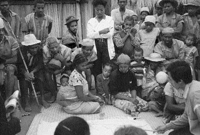
Photo 5: In the feedback meeting, the information collected during the study is verified.
The population showed great interest in the results of the study and seemed to feel that the team had captured the key issues well. Several minor amendments and corrections were offered, which reassured the researchers that the audience was listening with a critical ear and not just agreeing out of politeness.
Two members of the team expressed thanks to the whole village and explained again how the information from the study would be used and what the team would be doing next as it continued similar studies in other regions of the country. Three kinds of rum appeared as if from nowhere, and villagers and team members shared a last libation before bidding one another a fond farewell.
After the team's return to Antananarivo, the members divided up the objectives so that one or two people worked on organizing information under each objective. The large flipcharts where information had been summarized after each field activity were cut up and arranged by objectives around the wall of the meeting room. These subgroups worked for two days and, on the second afternoon, the team reconvened to consider the information collected. Each group or individual presented a detailed outline of his or her section. Where information was missing, other team members helped to complete the outline; it was also easy to see where there were overlapping sections so that the duplications could be eliminated before the final paper was written.
As the group worked on these questions, it realized that a last synthesis chapter was needed to capture the overall findings of the study and to summarize the causes and consequences of land degradation. An analytic framework (figure 2) was developed to push the team to think through the implications of the vast amount of information that had been collected during the field study. The framework organized the descriptive information under three categories: (1) characteristics of the community (including production systems, social structures and the political, economic and geographic context), (2) characteristics of the tenure system (both customary and state rules systems) and (3) characteristics of the resource base (including the kinds of resources, their abundance or scarcity and an evaluation of whether they are degrading or enriching).
Having organized the information according to these categories, the framework then pushed the team to use the information to explain why the community uses resources the way it does and to reflect on the implications for sustainable resource management. The team asked itself, for example, what characteristics of the community were important in defining the village tenure system and how, in turn, the tenure system (including external rules) affected the life of the community. Similarly, the tenure system has characteristics that create incentives (and disincentives) for how resources are used. Does it encourage or discourage the use of resources in a sustainable, equitable and efficient manner? How does the nature of the resource base influence the tenure system? As resources become more scarce, for example, is the tenure system adapting and are use rules becoming stricter?
The next two chapters discuss these questions, pulling together information from all the activities carried out during the seven-day field study of tenure and resource management in Anivorano. Chapter 4 is largely descriptive, looking at the community, its resources and the tenure/resource management systems used by the community to manage its resources. Chapter 5 then focuses on the analytic arrows linking the descriptive boxes in the model below and considers the implications for sustainable resource management.
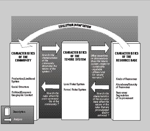
This model was conceived by the team during the analysis phase of the study and was used to organize the information gathered during the fieldwork.
Anivorano lies 158 km southeast of Antananarivo in the province of Tamatave, the fivondronoana (department) of Moramanga, the firaisana (district) of Lakato and the fokonolona (rural community) of Anivorano. It is the largest hamlet in its fokonolona and serves as the administrative centre. Six other villages comprise the fokonolona with Anivorano. The village perches on a hill and is surrounded by an undulating territory that drops steeply away from the inhabited part of the village. This settlement is occupied for only a few months of the year (June to September), when the villagers return to live in a nucleated community. For the remaining nine months of the year, villagers disperse to live in small houses they construct in their fields, leaving only a skeleton population to assure the security of the core village.
Significant in the landscape is the new (1992) laterite road that winds perilously across the hillsides from the main road at Moramanga and continues a few kilometres beyond Anivorano to Lakato, where the lowest-level government officials are based. Before the road was built, Anivorano was served by only a track and was isolated from most outside commercial interests. Since the coming of the road, several shops have opened in the village, bringing outside residents into the community for the first time. Trucks now ply the road between Moramanga and Lakato, stopping at villages to pick up wood that has been harvested from community lands for export to the cities of Madagascar and to more distant destinations, including Japan. Before the road, commercial exploitation of Anivorano's resources was limited to intermittent attempts at mining beryllium and quartz. Now, three outside woodcutters have obtained government-issued permits to exploit the village forest, and a mine has been reactivated. The village is still vulnerable to isolation at times of the year when heavy rains make the road impassable.
The residents of Anivorano are all from the Betsimisaraka ethnic group, with the exception of the few outsiders who have come to live in the village for commercial purposes since the opening of the road. The village is approximately 200 years old and has a population of about 300 people, all of whom are descended from the same ancestors. The village is now divided into four sub-families. The common origin of the village population is a key factor in the success of the social cove-nants that govern tenure and resource management practices in the community.
Anivorano is also related by blood ties to the other villages in the fokonolona. These villages have, at certain times in their history, formed a single community while, at other times (such as the present), they have separated into distinct hamlets. The land that comprises the current village of Anivorano is, from the point of view of village residents and neighbours, clearly defined by known territorial boundaries and has been passed on from the ancestors who served as the root stock for the current village population.
Two different but complementary socio-political structures govern life in the village and larger fokonolona: indigenous institutions reflecting a long village tradition and outside institutions created by government decree. (See diagram 3: Venn.) Traditional village structures are active and dynamic. At the apex of these traditional structures is the Tangalamena (traditional religious leader), who is considered the intermediary between the living population and the village's ancestors and is responsible for maintaining ancestral customs and serves as president of the village tribunal. He carries a red cane to represent his authority. At the right hand of the Tangalamena serve the Ray aman dReny (RAD), or village sages, respected members of the community, either men or women and usually but not always elderly. The RAD advise the Tangalamena on issues of village importance, organize village events, such as community work days, and play a key role in mediating disputes.
The RAD and Tangalamena of Anivorano and the other six villages in the fokonolona frequently interact. They meet regularly to plan common village activities and to resolve conflicts that surpass the limits of any one hamlet.
In addition to the traditional authorities, government-mandated administrative structures also function at the village level. The village has a security officer (quartier mobil), a political "committee" and a President (PCLS) who reports to the authorities at Lakato.
The interaction between customary and administrative authorities is illuminating. The villagers recognize a clear set of administrative functions and responsibilities mandated by the State. These require, in some cases, skills (literacy) or capabilities (to travel) that would be beyond the capacity of traditional leaders. But at the same time, the population has been loath to see the State create parallel structures that might usurp the traditional authority handed down from the ancestors, who play a critical role in Betsimisaraka life. The local solution has been to integrate the two systems and largely co-opt the state structures into the customary arrangements. Hence, the government structure's PCLS has been made a member of the indigenous RAD, even though he is considerably younger than the norm for such elders. In this way, he is under the influence and tutelage of the traditional village leadership as he carries out his modern administrative functions. This is just one of several indicators noted during the study of the continuing force of these traditional structures, essential elements in the maintenance of effective customary tenure systems.
The youths of the village are frustrated by the limited role they are accorded in decision making where the RAD are clearly ascendant. The youth organization is largely devoted to carrying out plans initiated by their elders. While the RAD are officially charged with the task of conserving the resources inherited from the ancestors, there were some indications that their interest in reaping short-term benefits may temper their zeal to protect resources for the future. For example, as influential people, they can ensure that their sons get jobs with the commercial forest cutters. Some of the village youth, who have a longer time horizon than the elders, seemed more systematically to espouse conservation and sustainable development principles. Their views are given little weight, however, in village decision making. One consequence is that some youths, frustrated by the elders' failure to control the exploitation of community resources by outsiders, have begun to "poach" these resources themselves. In this way they ensure themselves at least some short-term benefits since they have little hope that the resources will last into the future.
The household economy for a typical family in Anivorano receives revenues (and goods in kind) from agriculture, forest exploitation and mining. Almost all families have at least some revenues, though perhaps small, from each of these sources. For most, agriculture is the principal pillar of their livelihood (see diagram 6: Family economy matrix). Only some very young families with few or young children relegate farming to a secondary position while the male head of household earns wages from forest cutting or mining.
Agriculture is centred primarily around the production of upland rice on the slopes around the village. Villagers try to produce as much rice to meet the family's needs as they possibly can, given labour constraints. Some small portion of the rice harvest may be sold to meet urgent cash needs, but most of the rice harvest is consumed. To the extent that there is a shortfall in rice production, revenues from cash crops are used to purchase the remainder of the family's cereal requirements.
Other hillside plots are devoted to perennial crops, including coffee, avocados, bananas and diverse fruits. Manioc is also planted in these fields. These crops are partly used for home consumption and partly sold.
To understand resource use in Anivorano, it is critical to understand, first, the primordial role of rice in the village economy and, second, the peculiarities of the rice production system on the steep slopes that make up the village territory. The land area suitable for lowland, irrigated rice production is infinitesimal and insufficient to provide even small plots to each of the families in the village. In the past, this land was cultivated, but the irrigation system that serviced the rice fields was destroyed by a landslide in 1972. It was never replaced because cost of repairing a system (originally installed by outsiders) of such limited benefit was too high. Since that time there has been no irrigated rice production in Anivorano, and the population has had to rely on upland, hillside rice.
Most of Anivorano's rice is produced in tavy fields. In Madagascar tavy refers to the practice of cultivating recently cleared hillside land. In this production system, slopes are cleared (slash and burn), cultivated for one or several years and then left fallow until the soils improve sufficiently to permit cultivation again. The secondary growth is then cleared and the cycle begins again. In Anivorano, one year of cultivation is typically followed by five years of fallow. For the farmer, tavy has the advantage of requiring relatively little labour and few implements on parcels where the slopes are too steep for the use of animal traction.
The soils found on these steep slopes are extremely thin, fragile and subject to erosion when cleared. This explains why a five-year fallow is required between each crop cycle. Without such a fallow, yields drop precipitously. Even with consistent five-year fallows between crops, yields decline progressively as the soil deteriorates after each harvest (see diagram 7: Rice production pattern). A yield of 10 units on a given plot that has been recently cleared of its forest cover will decline to three units after 25-30 years. During this period, only five rice crops will have been harvested; the rest of the time the land would have been in fallow. After roughly 50 years of use (10 harvests), the land becomes barren for food production purposes.
Perennial tree crops, such as coffee and avocados, and annuals, such as manioc and bananas, are planted lower on the slopes and do not require the same kind of rotation system. They may remain in the same area for decades, and soils are generally reported to improve over time where perennials have been established.
Three commercial woodcutting operations have received permits from the Government to exploit the forest at the edge of the village territory. This provides employment opportunities for the young men of the village, especially during the dry season. While the work is hard and the earnings are at best modest, there are few other income-generating opportunities in the area, and the contribution of this wage labour to the household economy can be significant.
Since all the villagers descend from a single family, there are no significant social distinctions to jeopardize the cohesiveness of the community. There are, however, variations in wealth (see diagram 4: Wealth ranking). Villagers themselves distinguished four wealth categories.
The wealthiest group, representing less than 10 percent of the population, has enough land and labour to produce a surplus, usually engages in such off-farm remunerative activities as commerce, and has invested in cattle. This class is largely composed of young people who have "struck it rich" thanks to their business acumen or the accumulation of wealth outside the community that has permitted them to invest locally, hire farm labour and increase their agricultural holdings.
The second-wealthiest category comprises roughly another 10-15 percent of the village. Their agricultural production is sufficient to meet their family needs and, occasionally, to produce enough surplus to invest in cattle.
The third category is larger, with about 30 percent of the village. These families own no cattle and can only barely feed themselves from their agricultural production. The fourth, and largest, category accounts for nearly 40 percent of the population. These people have no cattle and insufficient labour to produce enough for their needs. They make up the shortfall by working as field hands for other families. This category consists largely of young families, though it includes a few older people, struggling as a result of sickness or death in the family. Several widows belong to this group.
While the young, with the few exceptions of those who have struck it rich, are generally in the poorest economic strata, over time considerable upward mobility through the ranks is possible. As young families have children who can begin working in the fields, they obtain more land and increase their production until they reach a point where they are self-sufficient in agriculture. At the peak of their productive capacity, some can even produce a surplus. The flexibility in the system of land allocation that permits this ascending economic mobility for the young is an important feature of life in Anivorano. The possible implications of a land-titling programme on this arrangement will be taken up in chapter 5.
The territory of Anivorano comprises about 18 km2 of land covering several steep hill slopes (see diagram 2: Transect walk). The boundaries of the territory follow the top ridges of the mountains at the periphery. By ancestral rules, all the land in the territory belongs to Anivorano except one communal area shared with Ambodigavo, a neighbouring village whose population belongs to the same lineage. Each of the villages must have the permission of the other before exploiting land in this shared area.
The territory is divided among different land use activities. Currently, about 20 percent of the territory, along the western boundary, is forested. This forest lies outside the borders of the nearby classified forest of Ankeniheny but is nevertheless considered by the authorities to be part of the national domain. At one time, the entire Anivorano territory was covered by forest, but this has progressively been cleared as land was needed for rice production (see diagram 1: Village territory map). Land in the territory is principally used either for rice production or for the fallow of lands that have been previously planted in rice. These lands are generally on the middle section of the hillsides. The tops of the hills are usually reserved in a band of uncultivated land to reduce erosion, and this land may be used as pastures since animals are less likely to succumb to disease if they are kept out of the more humid valley bottoms. The lower parts of the hillsides and the valleys are generally planted with perennials, tree crops and manioc.
Soil quality varies considerably over the territory. Primary and secondary forest areas are characterized by soils rich in organic matter. Similarly the areas at the bottom of slopes are highly fertile, with 25-50 cm of black soil enriched by deposits of organic material coming from the slopes above. The quality of soil in areas that have been cleared and planted in rice depends on how many times the land has been cultivated.
The quality of the soil in rice production areas can quickly be identified by the kinds of plants that regenerate during the fallow period (see diagram 7: Tavy rice 50-year production pattern). When the land is first cleared by tavy, secondary forest species grow back during the five-year fallows between the rice harvests for four planting cycles. By the end of the five-year fallow, small trees can be seen regrowing on these parcels. After the fourth time rice is planted, however, these species do not return. Instead, regeneration takes the form of a bush known as dingadinga. Dingadinga regenerates during the five-year fallow after the fourth, fifth and sixth harvests of rice. During this time, soil has deteriorated to the point where yields are only a third as high as they were when the fallow regenerated as secondary forest.
After the seventh rice harvest, the soil has deteriorated to the point where only dense bushes known as radrika, or corbeille d'or, will regenerate on the land. While yields are actually slightly better on this land than on dingadinga fallow, radrika is a spiny, matted bush that is extremely difficult to clear. Labour needs increase substantially on this land. Approximately two crops (with five-year fallows between them) can be harvested on this land before even radrika will no longer grow. At this point only ferns will regenerate, and rice yields are so low that there is little point in continuing production. Such land is generally left to long-term fallow.
The process by which land degenerates from rich, forested soils to essentially barren ground on which little but ferns will grow takes only about 50 years, during which time only eight or nine crops of rice can be produced. Villagers estimate that it takes more than 50 years of fallow to bring these "barren" soils back to the point where secondary forests will regenerate and rice can be planted again. The forester on the team felt that even this sobering figure might be too optimistic.
Currently, about 20 percent of the territory is in primary forest and about 15 percent is in secondary forest. The largest part of the territory (about 40 percent) is now in dingadinga, with the remaining 25 percent divided between radrika, ferns and the barren bruyre. This can be compared (diagram 8), with the situation 50 years ago when fully half the territory was primary forest and only about 10 percent was in dingadinga.
The forest of Anivorano is composed principally of endemic tree species, including the grand pallisandra. The populations of these more valuable species are being rapidly reduced by woodcutters who export the trunks and leave most of the smaller pieces to waste. Some of these remnants are gathered up by villagers, who have always exploited trees for such subsistence needs as housing construction, fences and fuel. The rate of cutting has increased dramatically since the road was built and outsiders were granted cutting permits for commercial exploitation.
Some of the land around Anivorano is rich in minerals, principally beryllium and quartz. Smaller deposits of other semiprecious stones, such as topaz, have also been found. While there have been periods in Anivorano's history when mining was practised quite intensively and buyers came from long distances to purchase the stones, at present production is rather rudimentary and ad hoc. Mining is, for the most part, practised by young men on their day off.
Two tenure systems operate simultaneously-and not always compatibly-in the territory of Anivorano. The first is the customary tenure system, based on the traditions of the Betsimisaraka people and handed down from the ancestors. The second is the administrative system governed by state rules and regulations.
The rules of the customary tenure system are embodied in the knowledge of the village elders. When speaking of this tenure system, the elders refer to a "covenant" of the ancestors that governs how natural resources can be used. All resources in the territory are, ultimately, the property of the ancestors, who accord use rights to present and future generations. Under the covenant, the land comprising the territory of Anivorano is inalienable and must remain the property of the ancestors. In addition, given that all members of the community are descended from the same ancestral stock, the covenant mandates that all will have equal access to land in relation to their need.
The territory defined by the ancestors comprised far more land than was needed at the time. From the beginning, it was established that part of the territory would be kept forested as a reserve whose purpose would be to meet the population's increasing needs for land over time. The covenant prohibits the ad hoc development of the reserve. Rather, clearing of any part of the forest requires a consensus decision by the village. In the past, this decision was entirely up to the elders, in consultation with the population. Now, the elders submit the village's request to the officials of the Water and Forest (Eaux et Forts) Department, which insists that its permission is required because the forested land in the village is part of the national domain. Once a decision is made as to what part of the forest will be cleared, according to tradition the Tangalamena and RAD distribute parcels among all the families who need land. In fact, in recent years the Forest Department has refused all such requests.
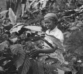
Photo 6: This villager explains about the importance of perennial plants in the production system and women's rights to trees.
When a family clears a part of the forest under this system, it becomes, at a certain level, the owner of the parcel. (There is universal recognition that, at another level, all the land of the territory belongs to the ancestors.) This family then has the right to either use the land or to transfer use rights to another individual or family in the village. The identity of the family who has primary rights to each cleared parcel in the territory is known, as are the boundaries of these parcels, even in cases where the land is essentially barren and has been put into long-term fallow.
The transfer of use rights to land is common and involves a minimum of protocol. In fact, such transfers are so easy and so common that the team had difficulty determining that clear primary rights to land in fact exist. The first explanation given by villagers was invariably, "Anyone can cultivate anywhere". Upon closer examination, however, the team learned that anyone who wants to cultivate land to which his or her family does not have primary rights is expected to ask permission of the primary rights holder. According to custom, no one who knew that the primary holder was using land would ask for it, and the primary holder would never deny permission to use land that was not needed. As a result, permission is largely pro forma and the transfers are almost automatic. This is the primary mechanism by which young families that have not yet inherited obtain their first access to rice- production land and by which growing families are able to expand the size and number of their parcels.
Arrangements are made more carefully when the user wants to plant perennial crops or trees. Whoever invests in the planting of trees becomes the primary rights holder for that parcel. Explicit permission is, therefore, required to plant trees. Young people who wish to establish an orchard or coffee plantation, but who have not yet inherited land, first request a rice plot from a close relative. By carefully maintaining that plot, they demonstrate that they are serious about their farming; in a later year, they ask if they may plant trees on that or another parcel. If this permission is granted, the "owner" is agreeing to transfer primary rights for as long as the trees exist on the parcel, even if they are not maintained or exploited.
The transfer of most primary rights to land takes place through inheritance. Both men and women have equal rights to inherit land as long as-and only for as long as-they continue to reside in the territory. If they leave (for example, men might go to the city for long-term work, or women might marry into another community), their land is passed to other members of the family who remain in the village. In the case of divorce, the man receives two thirds of the couple's cleared land holdings and the woman the remaining one third. Arrangements in the case of inheritance and divorce are made through the family elders. Any disputes are resolved by the Tangalamena.
It is, at least in theory, possible for outsiders to gain access to land of the territory if they agree to join the community and abide by the provisions of the covenant. Outsiders have only recently (since the building of the road) taken up residence in Anivorano, and as yet none have attempted to obtain land for anything but a single season of rice production. One family of shopkeepers, from a different ethnic group, would like to plant an orchard. Its members are making great efforts to demonstrate that they participate in community activities and respect local customs. They believe that if the villagers see that they are following local norms, they will have little difficulty obtaining land for their orchard.
In addition to these broad land tenure principles, the covenant defines numerous other rules and interdictions. These include the requirement that each family set aside one day per week when there will be no fieldwork. (While this was perhaps originally intended as a day of rest, now it is the time when many men work as woodcutters or miners.) The covenant also mandates that the best-quality lands will be shared among all the families of the village and in certain, particularly fertile, zones, each family has a small parcel. It also imposes restrictions on how and when certain wild plants may be exploited to ensure a rational and sustainable exploitation of village resources. (Some of the plants used for weaving, for example, cannot be harvested as long as the rice is still in the fields.) And, it protects certain areas considered sacred, such as the hill where the ancestors are buried. These lands can only be cultivated if a zebu cow is sacrificed to the ancestors and their permission is obtained. Because this event occurs so rarely, the fallow on these lands generally lasts much longer than five years and yields tend to be higher. Such an appeal to the ancestors might, for example, take place after a year with a particularly bad harvest.
The RAD, and particularly the Tangalamena, exercise considerable authority in making decisions about how resources will be used and managed in the territory. They designate community work days, decide where pastures will be located and oversee the maintenance of tracks, fences and the community water supply. However, where the covenant is concerned, their role is limited to enforcing its provisions and, to a certain extent, interpreting them. They do not believe that their authority extends to changing these ancestral edicts. Conflicts concerning resource management and allocation within the village are extremely rare, largely thanks to the community's social cohesion and widespread respect for the covenants.
"The land belongs to the State," according to official government rules. State rules, in practice, recognize neither village territories nor the local authority to manage lands which have not been titled, are not farmed continuously, and are considered part of the national domain.1 For the most part, state authorities have not concerned themselves with what happens on cultivated and fallow lands that the village considers its own. Tensions between state and local tenure systems are more common on forested lands. As described above, the territory of Anivorano includes a forested area that plays an important role in the long-term resource management strategy of the village. The Water and Forest Department believes equally strongly that villages do not and cannot own such forests, which belong to the State. This view is driven in part by the sentiment that the disappearance of the forests of Madagascar is largely due to slash and burn agriculture practised by peasants. Therefore-it is reasoned-external management is needed to protect the remaining forests from being cleared. The government retains the authority to manage such forests, including the right to grant permits to commercial woodcutters.
Officially, the State allows villages a nominal voice in the management of local forests. Woodcutters are supposed to obtain the agreement of the village where they want to work before they apply to the Water and Forestry Department for permits. The Department, for its part, is not supposed to grant permits unless the applicant has obtained the required permission from the villagers and can prove it. In reality, these provisions are little respected in Anivorano. Woodcutters reportedly strike deals with the authorities and then arrive in the village with papers already officially stamped. They then approach the elders to affirm what has already been approved at a higher level. As one elder asked, "What can we do when they come with papers already signed by the authorities? Even if we say no, we have no recourse; these people are far more powerful than we are."
Along with the authority to grant permits, the Water and Forest Department also promulgates rules regulating forest exploitation by restricting the types and size of wood that may be extracted. In Anivorano, such restrictions are either unknown or ignored by the permit holders. Even if the permit holder knows the rules, the labourers who actually cut the trees receive no instructions and have no knowledge that there are limits on what they should cut. According to villagers, the woodcutters respect neither rules on species and size of timber nor the boundaries of their parcels.
While granting permits for commercial exploitation of the forest, the authorities have made it clear that they will no longer entertain requests to clear forest lands for agricultural purposes. Villagers have been informed that anyone caught setting fires to clear land in the forest will be fined and/or imprisoned. Some youth of the village have already been subjected to these sanctions, which they regard as the price to be paid to ensure the future survival of their families.
The situation with the forest is a matter of grave concern to the population of Anivorano. From their perspective, lands belonging to their ancestors are being subjected to rapacious exploitation that is beyond their control, and they feel powerless to do anything about it. The objections of some members of the village are tempered by the revenues they receive from family members who work as wage labourers on forest-cutting teams. Others, and particularly younger members of the village, are concerned that these are but temporary benefits that come at the expense of future resources that will be needed as the village population grows.
The result is the breakdown of all rules-systems that might manage the forest with any long-term perspective. The State rules concerning forest management are not enforced, and indiscriminate cutting (by holders of permits issued by the authorities) is jeopardizing the future regeneration of the vegetation; it also sometimes exacerbates wind and soil erosion. Local rules which have protected the forest from anarchic exploitation for some 300 years are also being progressively undermined, however. The community can no longer manage the expansion of tavy in the forest because all requests are denied by the authorities. Young people in the village, seeing that trees and the land are being decimated by outsiders and fearing that they will lose both present and future benefits if they do not act quickly, have begun to clear land illicitly, expanding existing cultivation zones further into the forest. These newly cleared lands give yields far superior to what can be obtained on older fallows. This breaks down respect for the covenant which insists that (1) all available tavy should be used before any new cutting of the forest takes place and (2) tavy should be expanded only be done as a managed community effort.
Chapter 4 described certain characteristics of the community and its resource base. This chapter proceeds to examine the interrelations between the community and its livelihood strategies, the tenure system that has been developed to manage the resources of the community and the health of the resource base. In Anivorano, the natural resource base is rapidly deteriorating (see diagram 5: Historical matrix). The forest that once covered the entire territory, and only 50 years ago covered half of it, is now reduced to about 15-20 percent of the village's land. Soil quality rapidly deteriorates as land is cleared of its protective cover. The fertility of previously cleared fields deteriorates further with each cycle of rice production. This chapter explores the factors that exacerbate-or mitigate-this degradation and looks at policy measures and development activities that might contribute to more sustainable resource management.
Tavy rice production is at the heart of the survival strategy of the population of Anivorano. Historically, the amount of land cultivated in rice has grown in direct proportion to increases in the population. However, the system of rice production as it is now practised is not sustainable.
Even with the current fallows of five years between each crop, the soils of Anivorano are being rapidly depleted and yields progressively diminish. For land that has been worn out by rice production, a long-term fallow of at least 50 years is required to regenerate the soils and vegetation to a point where yields are once again respectable and the process can begin again. To continue rice production in Anivorano without clearing forests, the population needs at least 10 times as much land in fallow as it puts into production at any given time.1
Average yields in Anivorano are something on the order of half a ton per hectare, higher on newly cleared lands and lower on those that are further into the production cycle. Each adult consumes approximately 250 kg of paddy per year. At these rates, one hectare provides for the subsistence needs of two adults.
The present population of Anivorano is about 300 people, including both adults and children. To provide for the subsistence needs of this population, the village needs to produce more than 50 tons of rice, which requires about 100 hectares of land. (In fact, because of labour constraints, they cultivate somewhat less than this. About half the people do not meet their subsistence needs in rice and are obliged to purchase the remainder.) In order to avoid clearing new land for rice, the village would have to have more than 1000 hectares in fallow.
When the system is not in equilibrium, it requires regular inputs of fertile land because some farmers will not find land that is sufficiently regenerated when they are ready to plant. In Anivorano, the forested area has served as the principal reserve of land in these cases. When the previously cleared land is insufficient to meet the communities' needs, a decision is made to clear a parcel of the forest and to bring new land into the system. The historical map shows that this has been done regularly and at an accelerating pace over the past 50 years.
The pie charts in figure 3 illustrate the effect on the forest when population increases mandate that larger areas be cultivated in rice to meet the subsistence needs of the population. In 1945, the population of Anivorano was probably about 100 people. A population of this size would have consumed on the order of 19 tons of rice per year, implying a surface area cultivated in rice of some 38 ha. The size of the territory of Anivorano was then, as it is now, about 1800 hectares. This means that rice occupied about 2 percent of the territory. Ten times this amount, or roughly 20 percent of the territory, would have been in fallow, and we can estimate that perhaps 15 percent was in such other uses as habitations, perennial crops or unusable land. This suggests that at that time about 63 percent of the territory may have been forested, an estimate that is confirmed by villagers' recollections.
Moving ahead to the present, the population has now increased to about 300, requiring the production of about 56 tons of rice on 112 hectares. Since the size of the territory has not changed, rice now occupies about 6 percent of the village lands. This implies, however, that something like 60 percent of the land is in fallow at any given moment. If 15-20 percent of the land is still occupied by other uses, this means that only 15-20 percent of the land remains in forest, which, again, correlates with current observations.
From these estimates, we can see that the forested area of the territory has declined from more than half the territory to less than 20 percent over the last 50 years. This analysis also suggests that a further 2 percent increase in the population, leading to another 2 percent increase in rice production (requiring 10 times that amount in fallow) will decimate the remainder of the forest.
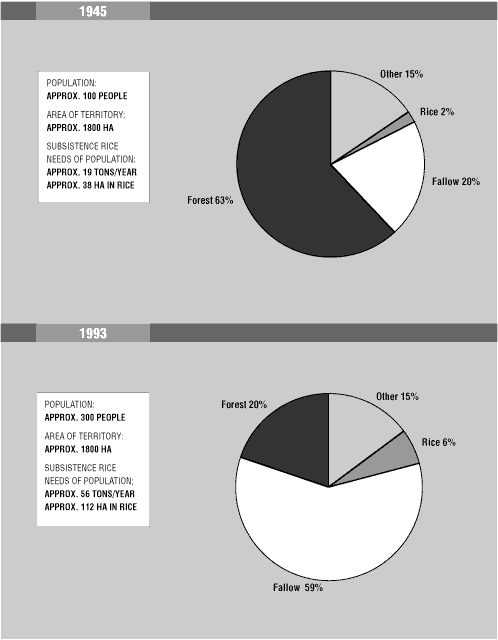
These pie charts were not made in collaboration with the population, but were constructed during the analysis phase of the study from information collected during the fieldwork. The figures used for these charts are approximate and represent rough orders of magnitude only.
The tenure system in Anivorano is principally oriented around the subsistence needs of the population and, especially, around the particular requirements of the tavy rice production system which requires such long fallow periods.
Among the most important attributes of the local tenure system are its insistence that the priority should be given to using land for the subsistence needs of the community and its high flexibility in reallocating land based on the individual's ability to put the land into production. Both of these characteristics ensure that the land is used as efficiently as possible to meet the needs of the village population and that the destruction of the forest reserve is kept to a minimum.
Were land redistribution not flexible, or were there significant costs to these transfers, then the forest would most likely be used as an individual reserve. Each time a family had a shortage of land, it would be tempted to clear a private parcel from the forest. As it is now, such actions are discouraged, and instead the system is oriented towards ensuring that everyone has access to whatever cultivable, previously cleared land is available. The forest in this case becomes a reserve of last resort, cleared only when the whole system is out of equilibrium and there is an overall shortage of land that can be cultivated.
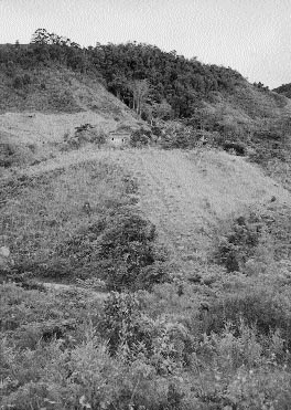
Photo 7: Fields of tavy rice cultivation below this homestead house and just at the edge of the forest reserve.
The local tenure system and practice of resource management is perfectly adapted to a production system that requires long fallow periods as long as there is an equilibrium between the size of the population and the amount of land that is available in rice production, fallow and reserve. When the area of cleared land is at least 10 times as great as the amount needed for annual production, the system will be more or less in equilibrium, with no need to clear the forest reserve to bring new land into production. In reality, however, the amount of land needed for rice production has increased over time as yields have declined and the population has increased. Since the populations of many villages have more than doubled in the last 50 years, it is not surprising that forest reserves both in and around villages practising tavy rice cultivation have been put under pressure.
If the Anivorano tenure system is evaluated on the criteria of equitableness, efficiency and sustainability, it earns high marks for the first two. The system makes highly efficient use of the limited land area available to the population (given known agricultural practices) and encourages long-term planning in the use of all resources. Rather than allowing all the land to be cleared at once so that the early populations could gain windfall benefits while condemning future generations to pay the price, each generation has been expected to use existing cleared lands as fully as possible before cutting forests to bring new lands into production. The system is also highly equitable, since access to land is principally determined by the capacity of the individual to mobilize the resources needed to make it productive.
The tenure and resource management systems have provisions which encourage the sustainable use of resources, such as the restrictions on rampant cutting of the forest reserve, as discussed above. However, when there is a conflict between sustainable resource use and the needs of the people to meet their subsistence needs, the latter takes precedence. When the population's needs outstrip the availability of cleared land, the reserve is sacrificed. That is, the needs of the current population are given priority over the needs of future populations. The result, as shown above, is that current resource-use patterns in Anivorano are not sustainable. Projections suggest that the community may face a severe crisis as early as sometime in the next 20 years. The forest reserve is likely to disappear altogether, and the people will face a shortage of fertile land on which to produce their subsistence food crop.
The forest of Anivorano is currently under severe threat. The threat comes from two sources: (1) increasing pressures from outsiders interested principally in wood collection and (2) the continuing and intensifying needs of the local people who are particularly interested in the rich soils of the forest.
Interest in exporting wood from the forest of Anivorano has accelerated since the opening of the road in 1992. It has been encouraged by the liberal dispensation of permits by the Water and Forest authorities. The commercial exploitation of the forest poses a particular problem because the norms for sustainable exploitation have been neither followed nor enforced. Rules regulating the number, size and species of trees that can be harvested exist, but have largely been ignored in practice.
The actual damage done to the forest by outside woodcutting interests is magnified by the effect of their actions on the local population, as will be seen below.
The principal factors that have, over time, incited the villagers of Anivorano progressively to clear their forest reserve have been spelled out: the population's need to produce rice, the lack of lowland rice production areas, the consequent need to use land on upland slopes, and the nature of soils on these slopes which require on the order of 10 years of fallow for every one year that a given piece of land is put under production. The progressive decrease in yields over time is another factor pushing towards the clearing of more fertile forest lands.
Until very recently, the clearing of these lands was carefully managed and kept to the minimum necessary to meet villagers' subsistence needs. In recent years, however, the internal mechanisms controlling the cutting of the forest by villagers have weakened. This is due largely to younger villagers' perceptions that resources that have been protected for generations risk being decimated by outside forces beyond their control. They feel, with good reason, that the village has almost no tenure security concerning the forested part of the territory and fear that neither they nor future generations will benefit from the resources if current exploitation patterns continue. This has led to "poaching" of forest lands by young people who have the strength to clear the land and seek to gain the benefits of higher yields by expanding production in the forest. In addition to the personal benefits this implies, it is believed that this strengthens the village's claims to the land: tenure security in relation to outsiders and the State is felt to be much higher on cultivated and fallow lands than it is in the forest.
In the long run, the woodcutters' indirect social impact-the undermining of local resource management covenants-may be more detrimental to the forest than the direct physical impact of their axes on the tree cover.
The research carried out in Anivorano highlighted several key issues concerning the management of forest resources. By understanding what is driving pernicious resource management practices, one can begin to reflect on appropriate policies to stem the environmental degradation that is as much a concern of the local community as it is to outside and international observers.
Forest "management" strategies now being followed in the territory of Anivorano protect neither the interests of the community nor the environment. The forest is rapidly deteriorating and faces imminent destruction if current practices continue. Careful reflection on the causes of this rapid degradation of a valuable community resource suggests two approaches which are critical to the future of the forest. Each is essential to saving the forest and neither will be sufficient by itself.
The first area requiring attention is the tavy production system: current rice production practices destroy the soils on which the population's livelihood depends and eventually drive the people to clear new land. The second area is related to tenure policy: tenure insecurity and the clash of local and state tenure systems is causing axes to fly and fires to burn in the Anivorano forest. What measures are needed to address these concerns?
Pressure to clear new lands is driven by severe soil degradation on already cleared lands and the need for long fallows, which take the vast majority of the village's lands out of production at any given point in time. Reducing pressure on the forest will require some change in the 1:10 ratio between the amount of land in cultivation and amount of land that must be in fallow. This might, for example, involve finding a technical alternative to the way crops are produced that would result in less rapid and severe degradation of the soil or identifying practices that would hasten its regeneration.
Regrettably, none of the team members had expertise in the area of hillside agriculture.2 The team felt that more in-depth studies of the farming techniques used in Anivorano, as well as alternatives based on experiences elsewhere and formal scientific research, are needed. If farming techniques can be adapted so that soil degradation is slowed or reversed on rice fields, and if methods are found so that each field can be used for more than 10 plantings before it has to be relegated to 50-year fallow, the need to clear more of the forest will at least be postponed.
Along with finding rice production techniques that are less harmful to the fragile hillside soils of Anivorano, pressure on the forest could be reduced by increasing the yields of rice. Most families in Anivorano do not seek to produce a surplus of rice. If they could cultivate more rice on smaller parcels, the parcels already cleared and in fallow would serve a larger population and there would be less need to clear new land. This would not solve the problem, but it would help to alleviate it.3
Another strategy for reducing the environmental degradation of the territory would be to strengthen and diversify income-generating options. The people could then produce less rice, which is the principal cause of soil deterioration, and purchase staples with income from other sources. This proposal, too, requires considerably more study, especially since most of the other income sources available to the population are natural resource-based (e.g., mining, forest cutting, production of mats and cloth made of reeds). If these alternatives were not based on sustainable production techniques, little would be gained by such diversification. One particularly interesting option to explore is the possible giving to the village itself of full authority to manage the forest (see below) accompanied by training in how such a reserve could be exploited commercially in a sustainable fashion. Similar planning might take place in the mining sector.
The principal reason for the state's insistence that it manage forest areas is ostensibly their protection and the promotion of more rational exploitation. In fact, as this study has shown, the effect in Anivorano is just the opposite. The state's actions have undermined local management strategies and have replaced them with nothing but anarchic profiteering. The result has been the decimation of valuable tree species, unsustainable woodcutting for short-term gain and increased clearing of the forest for crops. Current government policies are accelerating the destruction of the Anivorano reserve, rather than protecting it.
Conflicts between local and state tenure systems, and the ensuing sense of tenure insecurity faced by the population of Anivorano, are partially responsible for accelerated clearing of the forest reserve. One mechanism often proposed to reduce tenure insecurity is the titling and registration of land. The registration of land is not a new concept to Madagascar, which had one of the first titling programmes in Africa, dating to 1896. Concern about tenure security and the management of Madagascar's valuable natural resources has led to renewed interest in titling private property and has been promoted by the World Bank in recent years. Massive titling programmes are now under consideration and pilot titling initiatives are already being tested in some areas. Since Anivorano is not far from one of the pilot areas where titling is being carried out, and the village would certainly be affected by a national titling programme, the team considered the implications of such land registration for sustainable resource use in the territory.
When lands are titled, a decision is made as to who the "owner" of each parcel of land is, and this person receives a deed confirming his or her property rights. By far the most common form of titling is individual, meaning that a single person is declared owner and accorded the right to sell his land, rent it or otherwise dispose of it as he sees fit. Such individual titling of land is a characteristic of most Western tenure systems, which are based principally on the private ownership of land.
Over the past decade, there has been a push to title land in a number of African countries (Dickerman 1987), as governments seek to replace customary tenure arrangements with tenure systems based on private property or State-administered leases. This has been encouraged by some donors, who believe that the provision of formal, government-approved titles will slow the rate of environmental degradation. Individuals who have clear ownership of land will, it is assumed, have greater interest in protecting the resources on that land and will invest and intensify production on their parcels. In fact, the evidence on these points is not convincing in all cases, and debate over the merits of land titling in different situations continues (Barrows and Roth 1989). Individual titling programmes have been criticized for, among other things, the high expense of identifying ownership and issuing titles, problems with maintaining records over time and their failure to recognize that, under customary arrangements, there are often multiple rights holders for particular parcels. In addition, views of what lands are eligible for titling often conflict. In the past, Madagascar has predicated property rights on the continuous cultivation of land (for at least five years), which would exclude all tavy lands.
One alternative to individual land titling is the collective titling of land in the name of a community or group. For example, a title to an entire village territory might be issued in the name of the community. Such a system secures the boundaries and reinforces the integrity of a given territory, but permits customary tenure systems to operate within the territorial limits.
In reviewing the appropriateness of these possible titling options for Anivorano, the team felt that territorial titling would respond better to both the needs of the community and outsiders' concerns with creating a climate that will encourage more sustainable resource management. Territorial titling would strengthen positive aspects of the local resource management system and eliminate some of the current disincentives to sustainable management. Projections on the likely effect of individual titling are much more worrisome, however. The team felt that individual titling of private parcels would be not only highly problematic but also counterproductive in terms of its impact on the forest in Anivorano. The arguments for the territorial titling option are presented first, followed by concerns related to individual titling.
Titling the territory of Anivorano (as defined by the boundaries set by the ancestors and hence including the village's forest reserve) in the name of the population would give the villagers the right to fully manage the resources within the territory, to control outsider exploitation of the forest and to enforce a local management strategy. Anivorano has demonstrated its capacity to manage the resources in its territory and to adjudicate local disputes, both critical elements of a community titling programme. The State would have no role in making resource management decisions within the territory but would, where necessary, enforce decisions made by the villagers. This would particularly apply to outsiders' use of village resources, since they would not feel bound by internal village management mechanisms in the same way that residents are.
Giving villagers the right to control outsiders should restore the incentive to maintain the forest reserve for the use of present and future generations and reinstil the value of longer-term and sustainable resource use planning that is implicit in the village covenants of resource management. Because the villagers already demonstrate considerable concern for sustainable resource management, they would undoubtedly welcome further training in the more technical aspects of using forest resources sustainably or improving farming practices to conserve soil fertility. Such training would be a useful complement to actions granting the community official title to the territory.
The team had several concerns related to individual titling. First, it was apprehensive that such titling might weaken existing indigenous resource management strategies. As several members of the village pointed out, individual titling would be against the provisions of the covenant, which states clearly that land ultimately belongs to the ancestors. Individual titling would almost certainly undermine the moral force of both the covenant and the community elders responsible for enforcing its provisions.
A second group of concerns relate to the equity of an individual titling programme. Titling "officializes" the distribution of land at a given, and generally arbitrary, point in time. Research in Anivorano showed that land allocations change continuously as a function of changing family situations, labour availability, etc. Titling would fix the distribution, favouring those who happen to be at a point in their life cycle when they have high capacity to work the land and disfavouring those who are younger or who face other constraints.
This would, in turn, risk creating future imbalances between those who have land and those who have labour to work the land, a situation which has been almost nonexistent until now. Since the land up until now has been considered the property of the ancestors and has been available to those with the means to work it, there have been no land markets or fees associated with land use. The imbalances between those who have land and those who need it are likely to cause a market for land rental, once again arbitrarily favouring those who happened to receive titles and penalizing the others.
There is a also a considerable risk that women will lose rights to land under a titling system. At the moment, given the flexibility in land allocation, women and men have rights to land as long as they reside in the territory. Since titling would not be subject to this kind of provisional arrangement, and since the community would be wary of losing land if women were to marry outside the village and take their deed with them, in all likelihood they would not be accorded official titles.4
Third, individual titling may actually result in even greater pressures on the forest reserve. Under the local tenure system, as this research has shown, the forest is maintained as a reserve that is cleared for cultivation only when there is an overall disequilibrium between the population and the land already cleared that can be cultivated. In all other cases, individual needs for land are satisfied by the flexible system of loans-and even grants-and the expectation that anyone who has land he or she cannot cultivate will make it available to other members of the village.
Individual titling is likely to weaken the covenants that expect land to be shared and may well result in fees for the rental or borrowing of land. These transaction costs, along with the general reduction in the force of the covenants protecting the reserve, will increase the incentives and decrease the sanctions related to clearing new lands for production. The forest is likely to become the "reserve" for each individual who needs more land to cultivate, rather than the community's reserve of last resort.
In summary, the village of Anivorano operates under a dynamic and functional local tenure system that is highly adapted to the characteristics of the resource base and to the characteristics of the community and the social structure in which it operates. Better resource management and more sustainable use of the communities' resources can be achieved by reinforcing the village's capacity to manage its territory and renewing the incentives to manage it well. Titling the territory in the name of the community would be an important step in this direction. While such titling may be advisable, it is clearly not sufficient to ensure the protection of the forest. There is equally a need to address internal pressures on the system resulting from increasing populations on an ever less productive land base and particularly the effect of rice production on soil fertility.
Neither technical solutions nor policy changes alone will be sufficient to halt the alarming and accelerating degradation of the Anivorano territory. Progress in both areas is critical. If either falters, the forest of Anivorano will continue to disappear, tree by tree, until it becomes only a memory associated with the hallowed traditions of the ancestors.
While the last chapters have focused on Anivorano, this case study is not so much about that particular village as it is about how RRA can be used to study tenure and resource management issues. This section, then, steps away from Anivorano to reflect on the process of RRA, illustrating where possible with examples from this research. It discusses two issues in particular: (1) RRA's tendency to raise as many questions as it answers and (2) the role of quantification in RRA. While RRA is a powerful methodology, like any other method its effectiveness depends entirely on the researchers' skills and the seriousness with which they use it. In part because of the novelty of the method, there exist legions of examples of poor RRAs that have produced information that is neither interesting nor credible. As a reminder that RRA practitioners need to remain vigilant about the quality of their work, the chapter concludes with a reminder of some of the factors that are critical to doing RRA well.
Among RRA's greatest strengths is, undoubtedly, the ability of a well-focused study to gather impressive amounts of information in a very short time. The fieldwork in Anivorano was carried out in seven days and the full process outlined in this case, from preliminary steps to the writing of a detailed outline summarizing the conclusions and their presentation in a public forum, took place within a one-month period. The author has expressly avoided adding additional information that was not obtained during this period to illustrate what can be accomplished in so little time.
It is equally clear, however, that a study such as this one raises as many new questions as it answers. RRA researchers often avoid presenting conclusions at the end of their studies, preferring to speak of hypotheses in the belief that it is arrogant to suppose that one has definitive answers after only a week in the field. They often conclude their reports with a list of issues that should be pursued further. Whether one sees the list of new questions at the end of a good RRA report as a strength or a limitation of RRA depends on one's perspective. Many practitioners consider this capacity to generate useful questions and to expose the complexities of situations faced by villagers to be among the great attributes of RRA. Those, however, who expect neat, concise and above all simple answers find the lack of conclusiveness to be highly frustrating. In this case, it is worth reflecting on whether the frustration is with the methodology or with the inherent complexity of the issues-and the solutions-under consideration.
It is also worth remembering that the fact that an RRA raises a host of interesting questions does not diminish the importance of the information collected. In this case the findings of even this brief study have helped policy makers to sharpen the debate on tenure issues and encouraged them to question some of the assumptions that have driven the campaign to title private landholdings in Madagascar. This is, admittedly, just one case and its results can certainly not be extrapolated to the country as a whole, or even to a single region. But, if worrisome issues were raised here, might they not also surface in other areas?1 Similarly, development workers promoting more sustainable management of the forests in the Anivorano region have begun to reconsider their approaches and focus on resource management strategies (such as the covenants found in local tenure systems) of which they had been previously unaware.
A reconnaissance RRA such as this one is unlikely, by itself, to provide enough information to define a project's action plan. If the study is to inform development activities, there will undoubtedly be a need for further research: more in-depth inquiries in the same village (using RRA or another methodology) and/or studies in other sites if the activity is to cover a wider area. The follow-up research of the tavy rice production system in Anivorano is an example of a study that could lead to very specific development interventions. Having done the broader RRA study first, those who are involved in the follow-up will be sensitive to issues like the interaction of local and national tenure systems which may have a great impact on tavy management but which would be unlikely to surface in a highly focused, purely agronomic study.
Anivorano would also be an ideal community (especially if there is a programme to title the territory in the name of the community), in which to try a Participatory Rural Appraisal (PRA). In a PRA the population itself, perhaps with outside assistance, would undertake a planning exercise resulting in specific steps to improve the management of the resources in their territory.2
If the RRA is undertaken to inform a policy debate, one site is almost certain to be too small a sample from which to extrapolate broader policy recommendations. Instead, as in the research programme described in chapter 1, the researchers would want to cover other villages in different regions or in different ecological and socio-economic conditions.
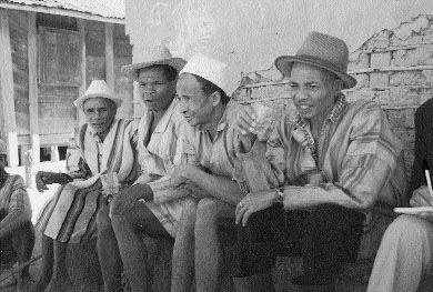
Photo 8: Villagers annoint an RRA activity with rum to invoke the blessing of the ancestors.
Questions about the role of quantification and measurement are often raised in conjunction with RRA. The reader has probably noticed that, even though RRA is considered to be a "qualitative" methodology, this report contains a great many numbers (the area of the territory, the proportion of the territory that is forested, the length of time that land lies fallow). These numbers are, in all cases, approximate, usually indicating little more than a rough order of magnitude. The key to using quantification in RRA-and it is an essential tool-is to find the level of precision that will shed light on and help the team to analyse the most salient issues coming out of the study. No more, no less.
In this case, knowing that the forest had gone from something more than half the territory to about one fifth of the territory in 50 years proved to be a critical piece of the analytic puzzle. Maybe it was a little more than 60 percent then, or only 10 percent now; that level of precision did not concern the team. The important issue was that information that there had been systematic and progressive clearing of the forest was triangulated using several different tools (map, matrix, bean quantification) so that the team felt confident of the trend and had a rough idea of its magnitude. With this information in hand, they could get to work figuring out how and why the forest had been cleared.
As it happened, several very rough figures turned out to be extremely helpful in putting together the picture of resource use in Anivorano as the team approached the end of the analysis. The team had estimates of the proportion of the territory in forest, the length of time rice lands must lie fallow, the approximate production of rice per hectare and the population of the village. The forester was able to estimate, based on detailed (secondary source) maps and his own transect walk, the very rough size of the territory. The socio-economist added a figure, based on her previous knowledge, for the approximate consumption of paddy by adults in Madagascar. When this information was summarized in the pie charts in figure 3, the dynamics of changing resource use in the community-and their implications for sustainable forest management-suddenly became very much clearer. More precise quantitative measures would have been of little use in this case; they would have taken much longer to gather (probably preempting the gathering of other useful information) and might even have distracted from the team's ability to discern the larger picture of what was happening.
There is no doubt that qualitative measures of this kind have their limits. Although for the purpose of this study, knowing that rice yields decline from a relative factor of 10 down to 1 over a 50-year period was sufficient and highly illuminating, someone who goes on to study the tavy rice system and what might be done to improve it will find these numbers of little use. Such a study would undoubtedly need much more precise figures on the decline in yields and precise measurements of the yields from various fields for comparison. In this case, precise quantification would be important because more detailed information would permit a more complete analysis of how and why yields change over time.
In conclusion, this case study has attempted to show that RRA can be a very powerful element in the researcher's tool kit of methods used to gather information on tenure and resource management. Like any methodology, RRA can be used well or badly. Its success depends on a number of key factors, among them:
The attitude of the researcher team to the local population. The effectiveness of RRA tools depends entirely on the relationship the researcher develops with the local population. The tools, admittedly, can help facilitate communication between people, but they work best in a context of genuine, caring human interaction.
The curiosity and interest of the team in learning. RRA may provide guidance on how to gather information but it cannot tell what questions to ask, or how to pursue a complex subject. Ultimately, it is the researcher's innate curiosity to learn more and ability to sense what question will draw forth interesting information that drives the process. Lackadaisical researchers will get mundane results no matter what method they use. When mixed with a strong dose of curiosity, the tools of RRA are highly effective in helping researchers to open themselves to new areas of exploration, alternative approaches to learning and surprising insights.
The willingness of individual researchers to collaborate in a common venture. It is critical that RRA researchers be willing to work together as a team and to apply their individual disciplinary interests to understanding the complexity of local realities. People who are concerned only with their own domain or who put personal professional interests ahead of the study objectives are of little use to an RRA team.
The commitment of the team to take time in the preparation, field study and analysis phases of the RRA. RRA may be rapid in relation to some conventional research methods, but it nevertheless requires a deliberate and most decidedly unrushed approach at each stage. Studies that do not take the time to prepare careful objectives end up as little more than a hodgepodge of ill-considered ideas. Those that do not take the time needed to build a rapport with the population, adequately prepare checklists and then really listen to what local people are saying will find that the resulting information is incoherent and superficial and that it does little more than reflect the researchers' preconceived notions. And those who do not invest the time and intellectual effort needed to carefully analyse and report the results at the end waste not only their own time but also that of the villagers who provided the information. Too many recent RRA practitioners have cut short one or more of these phases and in so doing have fueled criticisms not only of their own work but also, unjustly, of the methodology.
The attention of the team to such key methodological principles as triangulation. RRA is wonderfully flexible, but it does demand a respect for certain key methodological principles. In the field, when time is short and pressure is high, there is always a temptation to brush these things away as "academic details". But triangulation, as an antidote to bias, matters a great deal. It is a key factor in (1) assuring the accuracy of the information and (2) enhancing the team's ability to persuade anyone else that the information gathered is valid and therefore worth using. After all, information is only as good, after all, as people's willingness to believe it-and to act on it. Readers of RRA reports have a right to question how the methodology was used and to reassure themselves that the study was properly carried out and that the information is credible. Researchers will only be able to defend their sampling procedure for sites and their triangulation of research perspectives, tools and informants if proper attention has been paid to these issues throughout the study.
The issues confronting the world's environment are sobering and breathtakingly complex. No individual can possibly attack them in their ensemble, but each and every one can take on his or her own small piece. Many tools are needed in the effort. To the extent that RRA can increase understanding of the local complexities of tenure and natural resource management, it is a valuable tool in continued efforts to build a healthier planet through projects and policies that build on this knowledge to encourage more sustainable resource use.