


The two sections in this chapter report data collected in Long Segar and Long Ampung (in 1979-80 and 1991), and in Tanah Merah and Muara Wahau (in 1991). The first provides a unique chronology of one shifting cultivator community, Long Segar, over 28 years, and the second compares Long Segar and three other sites populated by the same ethnic group. The chronology of events has been divided into blocks of time during which different issues dominated community life. Looking closely at the changes that occurred can help identify the enduring components of a successful agroforestry system, along with the flexibility that system offers under changing circumstances.
Between 1962, when the first pioneers came to Long Segar, and 1969, much of the settlers' efforts were devoted to subsistence and adaptation to a somewhat different environment. The early years in Long Segar were atypical in having no major natural disasters such as droughts, rat infestations or major flooding. The Uma' Jalan freely followed their inclination to make ricefields in old growth forest, and by 1969, the 18 families who had moved to Long Segar had cleared roughly 162 hectares. From 1970 to 1974, the community grew quickly, adding Catholic and aristocratic families to the early Protestant commoner settlers, and it became a formal Resettlement Village. It also suffered two devastating years caused by extreme drought and an infestation of rats.
Long Segar's "Golden Age" was the period between 1975 and 1979, when the population reached its peak and gained access to several technological devices which significantly reduced life's drudgery (chainsaws, outboard motors and rice hullers). Between 1980 and 1984, the community experienced a decline: the Resettlement programme ended, 1982-83 brought another devastating drought followed by extensive forest fires that ravaged the countryside, and families began to leave. The final period of the study, 1985 to 1990, was marked by the dispersal of the community of Long Segar, and the formation of three new communities. A fourth community appeared to be forming some 15 km away in Pantun, an area where a logging company remains active.
1962-1969 The pioneering years
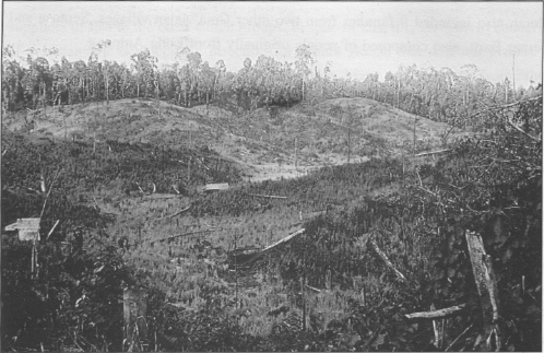
The first settlers in Long Segar were few in number and comparatively homogeneous socially (Protestant KINGMI commoners). As time passed social complexity increased, but at first the importance of environmental factors was undoubtedly preeminent. Although the old growth forests of East Kalimantan support a variety of wildlife and their overall biodiversity is nearly unequalled, the patchwork pattern of forest regrowth that one finds in longsettled areas like Long Ampung, with each stage of forest succession providing different products, is more conducive to human subsistence.
Producing rice was one of the settlers' first priorities. As noted earlier, rice forms the core of the Uma' Jalan subsistence system. Rice is eaten three times a day, and the need to produce rice is the most fundamental reason for clearing forest (Colfer 1981c, 1991a).' With the move to Long Segar, selling surplus rice also became an option.
Clearing the forest to produce rice also represents the first step in developing the system of forest patches of varying ages, each of which produces important products for use by humans. A detailed account of rice production in the first few years of settlement (with similar data presented in Appendix C for later years) is provided in the hope that this complex system could profitably serve as a model for agroforestry research. A description of the slow growth of population and forest use will shed light on the kinds of decisions made by these shifting cultivators when opening up a new site.
Forest type and topography are critical environmental factors affecting rice production. The number of fields under cultivation and the distance to these fields are also important factors in agroforestry decision-making among the Uma' Jalan. The instability of a rice monocrop in this agroecosystem will become clear. This lack of stability is one of several strong arguments against efforts to convert forest dwellers to conventional settled agriculture. The description of rice production and agricultural risk can be used by agricultural and forestry scientists interested in determining appropriate crops and management strategies which build on this agroforestry system.
The first couple came to Long Segar in 1962. They planted two fields, one near their house (the current village site), and another directly across the Telen River. Each in Long Segar field was 2.5 hectares, cut from old growth forest on lowlands.
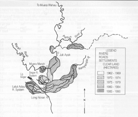
Dayak rice fields are typically located in clusters along major rivers as illustrated here. Cluster sizes per year were computed by dividing total number of fields by the number of years the location was used, and multiplying that by mean ricefield size in hectares. Calculations from five locations were omitted. When the people begin to use a new river system, they typically refer to the area very generally. There are several clusters now, e.g., in Pantun, yet all those in the general area reported their field to be in Pantun.
RIVER SYSTEM |
CLUSTER Name |
Est Km Year |
First Used |
Total N. Filds |
No. Years Used |
Avg Ha in Cluster Each Yr |
Long Segar |
Long Segar |
var |
1962 |
211 |
24 |
|
Telen |
ka' dips (airstrip) Batu Pagen Baran Muyut/Baran Tana' Bala Bua' Dong Juk Utui South of Kernyanyan acr. from Batu Pagen Batu Bulan Bai Bileng acr. from Boa' Dong Jawan acr. from Ba'i Bileng Juk Aya' Rantau Panjang |
0 1 3 2 4 3 1 6 9 4 10 9 8 10 |
1962 1967 1969 1969 1970 1972 1973 1973 1973 1974 1976 1977 1978 1980 1984 |
38 76 108 45 126 40 3 1 93 38 3 2 1 4 6 |
16 21 15 16 14 10 3 1 12 9 3 2 1 3 6 |
6,41 9,77 19,44 7,59 24,30 10,80 2,70 2,70 20,93 11,40 2,70 2,70 2,70 3,60 2,70 |
Kernyanyan |
Kernyanyan Lalut Layok Pejawan Lalut Dian Udu Alo' Lalut Alim Lalut Buang Pulau Lempu Lalut Amir Lalut Dengen Lalut Payau Lalut Durian Lalut Pi'a Tanjung Tipis Lalut Mebok Rantau Rindu |
var 4 2 5 5 3 3 6 8 7 9 7 10 9 7,5 5 |
1964 1970 1973 1974 1975 1976 1976 1978 1980 1980 1980 1980 1983 1984 1987 1989 |
337 48 44 106 4 73 18 7 60 63 7 12 12 5 2 8 |
19 13 10 16 4 15 10 6 9 9 4 6 4 3 2 2 |
9,97 11,88 17,89 2,70 13,14 4,86 3,15 18,00 18,90 4,73 5,40 8,10 4,50 2,70 10,80 |
Lalut Adau |
Lalut Adau Salie Lalut Birai Lidung Tamen Baru Lalut Lampeng Batu kepu Mudung Kapur Lulau Aru Lalut Dinjang Apau Medang Mudung Beta Apau Dado' Lua Putih |
3 1 1 3 5 0,5 6 9 2 6 2,5 7 4 |
1967 1967 1973 1976 1980 1980 1981 1981 1982 1985 1986 1989 1990 |
267 22 18 4 35 2 13 1 5 8 1 4 1 |
22 13 8 2 8 2 7 1 4 4 1 2 1 |
4,57 6,08 5,40 11,81 2,70 5,01 2,70 3,38 5,40 2,70 5,40 2,70 |
Marsh |
Long Melah Buri Marah Sg. Item Sg. Gesak Batu Dinding |
2 5 var 7 7 15 |
1973 1978 1981 1987 1988 1989 |
44 2 27 6 6 1 |
10 2 8 3 2 1 |
11,88 2,70 5,40 8,10 2,70 |
Pantum |
Pantun-Ngerung Pantun - Baturdi |
12 10 |
1983 1984 |
101 4 |
8 3 |
3,60 |
Location Unknown |
Loa Priyok Belau Nyibung Lalut Uei Lalut Me Lalut Simo Benasar |
4 3 2 1 7 |
1971 1981 1981 1985 1986 1989 |
1 2 6 1 1 3 |
1 2 4 1 1 2 |
2,70 2,70 4,05 2,70 2,70 4,05 |
OVERALL AVERAGE CLUSTER SIZE |
7,01 | |||||
Figure 3
Long Segar - areas cleared
in local river systems
(cartography by
Robert Abrams).
In 1963, they were joined by a second family. The original couple planted a small field of 0.5 ha, as they wanted to return briefly to Long Ampung to bring other people. The newcomers planted a 2 ha field, across the Telen River. The total land cleared was 2.5 ha, of which 2 ha had been old secondary forest. Again, both families planted on lowlands. That year the average yields were reported to be quite good for upland rice (2,337 kg/ha).
In 1964, the original couple planted a small field in the village and another larger one on the nearby Kernyanyan River, both cut from old growth forest. The other family again used old secondary forest in the village. All fields were in the lowlands. Total forest cleared was 3.5 ha, of which 1.5 ha was old growth. Fields averaged 1.16 ha. One field had poor soil and empty seed pods. Again, yields were high, with an average of 2,750 kg/ha.
By 1965, two more families had arrived. The four families each cleared one field, totalling eight ha, all old growth, within the current village. One family continued to plant on lowlands, but the other families switched to hilly areas. One family experienced some water shortage and another_, was beset by pigs, but yields remained adequate to good, with an average of 1,564 kg/ha.
In 1966, again two additional families arrived, bringing the total number of families to six. These families cleared a total of 19.5 ha for rice, with two of them clearing old secondary forest (nine ha) and the remainder clearing old growth. Average field size was 2.78 ha. Six fields were on the village site and one was across the Telen. Two families planted in lowlands; everyone else planted on the slopes. Only one family planted two fields, both in hilly areas. Two farmers had trouble with wild pigs and one with birds (upit2). Average yields remained adequate to good (1,322 kg/ha).
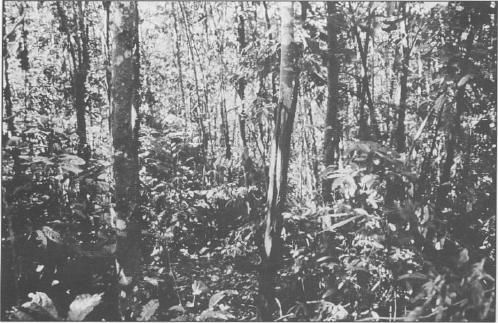
Two year old secondary forest
In 1967, the families were nine, and they planted 11 fields, one of which reached the exceptional size of 10 ha in order to feed new settlers. The settlers had expanded to three new areas. Three families planted in a small river system west of Long Segar, the Lalut Adau (see Figure 3; Table 1 gives names of field clusters by river system). Batu Pagen, north up the Telen, accommodated two fields, and one was at Salip, adjacent to the village. Five families continued to farm the area that now comprises Long Segar. The average distance of fields from the village rose above one kilometer for the first time.
Total land cleared was 30 ha, of which 4.5 ha was old secondary forest (cleared by three families) and the remainder was old growth. Average field size was 2.72 ha. Seven of the fields were in hilly areas, two (including the 10 ha field) were on lowlands, and one was characterized by mixed topography (information on the remaining one is missing). Agricultural problems included pigs in three fields and locusts in one. Two fields had poor soil, one had empty seed pods. Labour, a common constraint among the Uma' Jalan, was first mentioned this year, by two families. Again, harvests were considered to be adequate, with an average yield of 1,588 kg/ha.
In 1968, 11 families made 13 ricefields in the same areas as the previous year. They cleared 43 ha of forest, all old growth except one field which also included some old secondary. Of these fields, 11 were on hilly topography, with one reaching 9 ha. The remaining two fields were on lowland, and one of them was 10 ha. These large fields were again made in order to feed new settlers. Average field size had grown to 3.3 ha.
Six year old secondary forest
Two fields suffered some water shortage, one flooding and one wind damage. Four fields were plagued by pigs, two by rats, one by monkeys and one by upit birds. One field had pooor soil. Eight people had sufficient to good harvests and three did not. The mean yield/ha was 1,110 kg.
By 1969, there were 18 families making 20 fields in five main locations. Two more areas were added to the previous locations, both adjacent to the Telen River. Eleven of the fields were made in Long Segar proper. The total land cleared was 54.5 ha, of which 42 ha was old growth. For the first time, three fields were made in the previous year's ricefields. Two more were cut from young secondary forest and one from old secondary forest.
Average field size was 2.72 ha. Three fields were again of unusually large size, one of 7.5 ha and two of 5 ha, presumably as previously in preparation for more settlers to come. Seventeen of the fields (including the large ones) were on hilly ground, with three on lowland. Water shortage, a common problem despite the ample rainfall,4 was reported on five fields. Rats and pigs attacked three fields each, locusts and birds each attacked one field. Empty seed pods were reported on three fields, with an unspecified disease attacking a fourth. Of the three farmers complaining about the poor soil quality, one had planted a previous ricefield for a second year, one had planted young secondary forest, and one old secondary. Only one farmer reported any labour problems. Overall the year was reasonably good. Sufficient to good yields were reported by 13 farmers, and inadequate yields by five. Mean yields were 1,185 kg/ha.
Since the first farmers to settle in Long Segar initially were quite homogeneous - Protestant commoners without complex technological devices like chainsaws or outboard motors - the importance of environmental factors in their decisionmaking is probably more striking than at later times. Access to land, even now, is largely constrained by a families' access to labour to clear it. It is in this sense that land scarcity has not been an issue. Local wisdom and previous analyses (Colfer 1991a) suggest that forest type, topography, labour/time, and number of fields are the most important variables with regard to production and risk.
The Uma' Jalan, unlike some other Kenyah and many other Dayaks, prefer to make ricefields in old growth forest, the older the better. This derives from three important factors. First, cutting old growth forest traditionally establishes the cutter's rights of ownership in that land. Second, the weeding requirement in fields cut from old growth is far less. Third, production is believed (wrongly) to be higher in such fields.
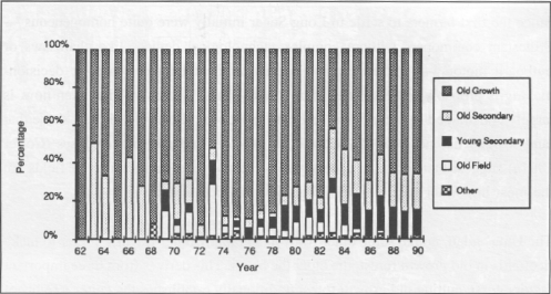
The percentage of Long Segar ricefields made from each major type of forest (old field, young secondary, old secondary, old growth, and other) has varied over time. It was not until the sixth year of settlement that any were made in old fields or from young secondary forest. In the first eight years of settlement, comprising 62 fields of all types, 76% were cut from old growth. This is not far from the 28-year average of 73%, covering 2,160 fields of all types (Figure 4).
The widely recognized advantage of making ricefields in lowlying areas near riverbanks must be weighed against the risk of floods in these areas. It is widely believed that the increase in logging activity over these years has resulted in an increase in flooding. Although the earliest families planted all their fields in the lowlands, by the mid-60s there was a definite shift towards hilly areas, and only a quarter of the fields were made on lowlands (see Figure 5). Over the first eight years, about half of the fields were in hilly areas and the other half in lowland. The distribution of fields across topography types for all 28 years5 is 70% upland; 18% lowland; and 12% mixed topography.
Rice harvesting at Long Segar
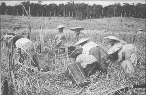
Figure 4
Long Segar:
percentages of different
forest types cleared for
rice fields each year during
1962 - 1990
The distance to ricefields (and consequent labour time used in travel) was a major consideration in Long Ampung, and becomes so in Long Segar in later years. Figure 6 shows the increase in estimated kilometers from village to ricefield each year.6 Clearly distance to fields was no problem in the early years.
The pattern of decision-making regarding number of ricefields also changed over time. One Long Ampung pattern had been to make a large swidden some distance from home, and a smaller one close by for ready access. This two-field pattern showed up in Long Segar in 1966, and occurred commonly thereafter. By 1979-80, the rationale had changed from convenience to risk aversion. One field was being planted in a lowlying area and one in a hilly area, or fields were being selected with mixed topography, for protection against floods and droughts.
Rice production in this environment is risky and variable from year to year. Yield by forest type and by topography was examined for all fields, excluding those where the crop had been completely destroyed by drought or rats. There was a tendency for fields cleared from old secondary forest to have higher yields (Figure 7). Fields created in old growth forest had the lowest mean rice yield (1,153 kg/ha) and old secondary forest had the highest (1,367 kg/ha). No other significant differences in rice yields among the forest types were found.
As noted earlier, the Uma' Jalan (as well as many tropical ecologists, foresters, and other environmental scientists) believe that fields cut from old growth are most productive.
But Soedjito (1985, 1990) and Riswan (1982) both provide evidence indicating that secondary forest soil has higher fertility than old growth soil. An analysis made near Long Ampung concludes that "secondary vegetation is more important, in terms of soil nutrients, in making nutrients available from the soil's total reserves, including from subsoil depths" (Soedjito 1985:40).
One factor in the Long Segar farmers' preference for old growth is they do not evaluate their agricultural efforts in kilograms per hectare. They are more likely to look at total production per unit of effort (cf. Dove 1984). This concern is common in extensive systems of land use like swidden agriculture. If a family has sufficient young male labour to clear old growth in the effort to minimize weeding, they are also typically able to clear larger areas, thus providing more rice to the family. Old growth is more productive per unit effort, rather than per unit of land. The lower weeding requirement of old growth is considered important, although the Uma' Jalan do spend considerable time weeding, even in fields made from old growth forest (Colfer 1981a).
Azier (1980) found in Kernyanyan (a Muslim Kutai village contiguous with Long Segar) that yields from rice crops grown on the previous year's ricefield often were higher than the first year. While acknowledging this fact, however, Long Segar residents again cited the much heavier weeding requirement .7
Dove (1980) attributes an important role to rainfall in people's decisions to use one or the other kind of forest, noting that high rainfall makes a good burn significantly more difficult in old growth forest. Table 2 shows rainfall during critical periods in areas near the study villages. In the East Kalimantan locations, drying begins in June, and burning in August. The amount of rainfall in these areas during this period is considerably lower than Dove found for the drying periods in his study of the Kantu' of West Kalimantan. This could be one of the explanations for the Kantu' preference for secondary forest, which is easier to bum in more humid weather. Again, a study of the Uma' Tukung of Long Sungai Barang (Mackie 1986) found that this group preferred to make ricefields in secondary forest, and this could be related to the significantly higher rainfall in this area than in the ones settled by the Uma' Jalan.
There is another important factor in the preference for old growth. Clearing old growth forest traditionally' establishes rights to land. Besides gaining additional rights, the user does not have to deal with any other established claims on the land. There is less need to negotiate and less potential for intra-group conflict. The Uma' Jalan interest in harmony may thus contribute to the belief that old growth is superior to other forest types for rice production, since it results in improved intra-group relations.
Mean Total Rainfall (mm)
Location |
July - Sept |
June - August |
yearly |
Ma. Wahau |
468 |
524 |
2353 |
Batu Ampar (1) |
478 |
527 |
2740 |
Tenggarong (2) |
378 |
412 |
1971 |
West Kal. (Kantu') |
1293 |
? |
4290 |
Long Sg. Barang |
? |
? |
4000 |
(1) Near Long Segar (2) Near Tanah Merah
Data from TAD 1982, Dove 1980B, and Mackie 1986B
The relationship between topography and yield is discussed briefly above. Flooding typically destroys entire fields, and only affects lowlands. Low, flat areas tend to have a large proportion of both excellent and zero yields. Mean rice yields from each of the three topographical types - lowland (833 kg/ha), hilly (1,000 kg/ha) and mixed (1,133 kg/ha) - were all significantly different. The fact that, over time, the people switched to a preference for mixed topography when available reflects their continuing adaptability and learning.
The population of Long Segar grew more swiftly between 1970 and 1974 than at any other time (due primarily to in-migration from Long Ampung), increasing from 18 families in 1969 to 106 by 1974. The influx of large numbers of people precipitated several important social changes, transforming the village in a very short time from a homogeneous settlement of Protestant commoners to a potentially stratified one. Among the newcomers were a number of Catholics as well as members of the traditional aristocracy, and the effects of status (aristocratic or commoner) and religion on rice cultivation reflect the equitability of the Uma' Jalan agro-ecosystem in Long Segar. The Indonesian Government also included the village in one of its resettlement programmes during this period. One goal of this inclusion was to reduce forest clearing by encouraging settled agriculture among the Dayaks.
The most significant natural phenomena to occur during this period were a devastating drought in 1972 and a rat infestation the following year. These were truly tests of the sustainability of the agroecosystem in the face of dramatic natural disasters. In such times of stress, the people's dependence on their forest environment becomes exceedingly clear. Their diet shifts from rice-based to cassava-based, supplemented by foods (plant and animal) from the forest and the river.
The total number of hectares cleared between 1970 and 1974 was 1,042 (Table 3). Use of old growth remained high during this period, averaging 74% per year. One interesting pattern, after the disastrous harvest of 1972, was the significant shift from use of old growth to other forest types.
A similar pattern was apparent after the 1982 drought. This use of other forest types is related to the need for men to go away to hunt and fish or to make money for subsistence, and the consequent shortage of labour for forest clearing. Similarly there is a shift to lowlying areas after 1972, in response to that year's disastrous yields (Figure 5). The 1972 high of 94% on uplands dropped to 60% the following year.
There was also a change in the number of fields cleared per family following the big drought. In 1972 only 10% of the families had more than one field, whereas in 1973 that figure more than doubled to 22%.8 The steady rise in distance to ricefields continued during this period (Figure 6).
FIELDS CULTIVATED |
AVERAGE YIELD KILOS PER HECTARE |
AVERAGE DISTANCE TO FIELDS (km) | |||
YEAR |
N |
AVERAGE SIZE (ha) |
TOTAL AREA (ha) | ||
1962 |
2 |
2,50 |
05 |
0 |
|
1963 |
2 |
1,25 |
03 |
2338 |
0 |
1964 |
3 |
1,17 |
04 |
2750 |
0 |
1965 |
4 |
2,00 |
08 |
1565 |
0,25 |
1966 |
7 |
2,79 |
20 |
1323 |
0,29 |
1967 |
11 |
2,73 |
30 |
1588 |
1,09 |
1968 |
13 |
3,31 |
43 |
1110 |
1,15 |
1969 |
20 |
2,55 |
51 |
1229 |
1,15 |
1970 |
41 |
2,31 |
95 |
1176 |
1,41 |
1971 |
44 |
2,39 |
105 |
1351 |
1,68 |
1972 |
109 |
3,22 |
352 |
72 |
2,05 |
1973 |
126 |
1,61 |
203 |
420 |
2,2 |
1974 |
119 |
2,42 |
288 |
1342 |
2,84 |
1975 |
123 |
2,49 |
306 |
1026 |
3,02 |
1976 |
124 |
2,82 |
350 |
903 |
3,19 |
1977 |
129 |
2,69 |
347 |
1015 |
3,73 |
1978 |
147 |
2,30 |
339 |
970 |
4,44 |
1979 |
189 |
2,09 |
396 |
405 |
4,92 |
1980 |
69 |
2,51 |
331 |
1166 |
5,52 |
1981 |
71 |
2,48 |
333 |
1215 |
5,41 |
1982 |
67 |
3,07 |
363 |
143 |
5,91 |
1983 |
74 |
1,87 |
295 |
1142 |
6,03 |
1984 |
82 |
2,17 |
335 |
1278 |
5,91 |
1985 |
87 |
2,23 |
272 |
1229 |
6,01 |
1986 |
83 |
2,25 |
222 |
1156 |
6,79 |
1987 |
93 |
1,93 |
179 |
1096 |
6,13 |
1988 |
103 |
1,96 |
202 |
1361 |
6,41 |
1989 |
117 |
2,37 |
278 |
1495 |
6,94 |
1990 |
113 |
2,68 |
303 |
889 |
6,71 |
OVERALL AVERAGE |
2,35 |
209 |
1169,75 |
3,49 | |
TOTAL |
6.054 |
||||
Years in italics (1980-1986) include estimated hectarages for out-migrants
To this point, analysis has focused on individual fields. The effects of aristocratic status on forest clearing and rice production will become apparent through analysis by family, since one family can have one, two or even three fields.
Although the aristocratic-commoner differentiation is widely discussed in the literature (see Whittier 1973, for instance), during the 1979-80 research in Long Segar and Long Ampung, the difference seemed to have all but disappeared.9 However, it is clear that the differentiation, though muted, still has an impact on forest clearing patterns and rice yields.
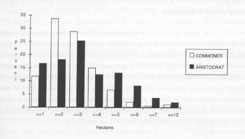
Commoners, comprising about 80% of the families, typically have somewhat smaller ricefields than aristocrats. Among the commoner families, 46% had ricefields of less than 2 ha and only 4% had fields of over 5 ha. Among the aristocrats, 35% had fields of less than 2 ha and 14% had fields of more than 5 ha (Figure 8). Thus the average total hectarage for a commoner family was 2.60 hectares, and for an aristocratic family, 3.13 ha.
Total rice production per family per year is presented in Table 4. There was a slight but significant tendency for aristocratic families to harvest more rice. The mean amount of rice harvested by commoner families was just under 2,500 kg per year, significantly lower than the 3,014 kg harvested by aristocrats. Larger family sizes among the aristocracy, which Whittier (1973) found in Long Nawang, was not a factor in Long Segar. In the 69 families whose status was known, between 1980 and 1990 commoners had an average family size of 6.07 and aristocrats of only 5.27.10
It is not clear what accounts for the higher production of aristocrats, who produce an average of 572 kg per person per year, as compared to 411 kg per person for commoners. Tradition grants them the right to first choice of unclaimed lands, though no consistent difference in field types was found in this sample. Another likely mechanism would be their traditional right to labour from others, but this was not visible in the field.
Beads and designs which are symbols of the aristocracy
TABLE 4 - LONG SEGAR. PERCENTAGE
OF FAMILIES HAVING VARIOUS LEVELS OF TOTAL RICE PRODUCTION DURING EACH YEAR
(1963-1990)
(Famil rice, - roduction includes rice produced from all the family's fields)
YEAR |
TONS OF RICE PER FAMILY |
No. of F amilies | ||||||||
none |
less than 0.5 |
0.5 to 1 |
1 to 3 |
3 TO 5 |
5 to 7 |
7 to 10 |
more than 10 | |||
Percent of Families | ||||||||||
63 |
0 |
0 |
50 |
50 |
0 |
0 |
0 |
0 |
2 | |
64 |
0 |
0 |
0 |
50 |
0 |
50 |
0 |
0 |
2 | |
65 |
0 |
0 |
0 |
50 |
50 |
0 |
0 |
0 |
4 | |
66 |
0 |
0 |
0 |
50 |
0 |
50 |
0 |
0 |
6 | |
67 |
0 |
0 |
11,1 |
22,2 |
22,2 |
33,3 |
0 |
11,1 |
9 | |
68 |
9,1 |
00 |
54,5 |
9,1 |
0 |
9,1 |
18,2 |
11 |
||
69 |
16,7 |
11,1 |
5,6 |
16,7 |
27,8 |
5,6 |
11,1 |
5,6 |
18 | |
70 |
2,8 |
5,6 |
16,7 |
30,6 |
19,4 |
13,9 |
8,3 |
2,8 |
36 | |
71 |
5,1 |
2,6 |
10,3 |
41 |
20,5 |
12,8 |
2,6 |
5,1 |
39 | |
72 |
69,1 |
22,7 |
3,1 |
3,1 |
2,1 |
0 |
0 |
0 |
97 | |
73 |
32 |
23,3 |
19,4 |
20,4 |
2,9 |
0 |
1 |
1 |
103 | |
74 |
0,9 |
3,8 |
6,6 |
36,8 |
24,5 |
15,1 |
8,5 |
3,8 |
106 | |
75 |
4,3 |
7,8 |
10,4 |
39,1 |
21,7 |
8,7 |
7 |
0,9 |
115 | |
76 |
1,7 |
4,2 |
12,5 |
46,7 |
23,3 |
8,3 |
2,5 |
0,8 |
120 | |
77 |
1,7 |
7,4 |
10,7 |
38,8 |
25,6 |
10,7 |
1,7 |
3,3 |
121 | |
78 |
3,9 |
9,4 |
7,1 |
44,1 |
19,7 |
11 |
3,1 |
1,6 |
127 | |
79 |
40,7 |
10,2 |
6,8 |
22 |
15,3 |
5,1 |
0 |
0 |
59 | |
80 |
3,3 |
0 |
8,3 |
40 |
35 |
5 |
8,3 |
0 |
60 | |
81 |
4,9 |
1,6 |
6,6 |
36,1 |
31,1 |
8,2 |
8,2 |
3,3 |
61 | |
82 |
54,8 |
27,4 |
6,5 |
9,7 |
0 |
1,6 |
0 |
0 |
62 | |
83 |
1,5 |
6 |
16,4 |
47,8 |
17,9 |
9 |
1,5 |
0 |
67 | |
84 |
0 |
2,7 |
2,7 |
51,4 |
29,7 |
9,5 |
2,7 |
1,4 |
74 | |
85 |
2,7 |
1,4 |
4,1 |
35,1 |
40,5 |
9,5 |
5,4 |
1,4 |
74 | |
86 |
1,3 |
5,3 |
6,7 |
42,7 |
25,3 |
14,7 |
4 |
0 |
75 | |
87 |
3,8 |
2,5 |
13,8 |
45 |
20 |
12,5 |
2,5 |
0 |
80 | |
88 |
1,1 |
6,7 |
7,9 |
40,4 |
29,2 |
9 |
3,4 |
2,2 |
89 | |
89 |
0 |
1,1 |
5,3 |
33,7 |
27,4 |
17,9 |
10,5 |
4,2 |
95 | |
90 |
2,1 |
7,2 |
10,3 |
52,6 |
17,5 |
6,2 |
2,1 |
2,1 |
97 | |
10,8 |
7,8 |
9 |
36,5 |
21,1 |
9,1 |
3,9 |
1,8 |
1809 | ||
Overall Average |
Total | |||||||||
Figure 8
Average size of fields cleared each year by commoners and aristocrats, Long Segar, 1962 - 1990.
Another possibility, difficult to demonstrate, is that aristocrats work harder at being good rice farmers. A philosophy of noblesse oblige, a responsibility to lead and a sense that the welfare of the community is in their hands are all conceivable motivating values. This type of mechanism would also serve to redistribute some of the additional resources available to aristocrats.
Social grouping by religion could potentially affect rice production and equitableness. Christianity is fairly new among the Uma' Jalan (section on "Religion," Ch. 1), and the division between Catholics and Protestants is even newer. There were no notable differences in 1979 between the lifestyles of Protestants and Catholics, other than attendance at different churches. But by 1990, the community of Long Segar was split quite distinctly by religious affiliation, with different. leadership, areas for rice cultivation, conduct of the church women's groups and organizational abilities.
There was a slight but significant tendency for Catholic families (n = 513) to have larger field sizes than Protestants (n = 1,280), but there was no significant relationship between total hectarage per family planted by the two groups. Nor was there any significant difference in the overall mean field size for the two groups. The same was true for average family production by religion. Mean rice production per family per year for the two religions shows no significant difference.
In terms of distribution, Catholic hectarage and production tend to cluster toward the high end of the center, whereas the Protestant values range more widely over the continuum. All new villages have been initially settled by Protestants, which may indicate that Protestants are greater risk takers, or that Catholicism emphasizes a more pastoral/agricultural lifestyle. However, religion does not seem to be significantly related to production.
In 1972, Long Segar was declared a Resettlement Project, thus becoming eligible for and subject to various kinds of government assistance and involvement in many aspects of village life. This marked the beginning of regular and formal interaction between the villagers and the central government. The resettlement programme helped the community learn to deal with a central bureaucracy, and introduced community members to some new technology. However the Uma' Jalan pattern of male circular migration meant that the people were already aware of many items to which they had no personal access. The government also provided the community with some emergency rice supplies after the 1973 rat infestation.
An important goal of the resettlement programme was to reduce forest clearing by converting shifting cultivators to sedentary wet rice agriculture. The amount of forest cleared rose dramatically during this initial period of involvement in the resettlement programme (1972-1980), and remained high throughout its duration. All those "resettled"" converted from a system which depended primarily on secondary forest for its rice fields (Long Ampung) to one which made yearly inroads into nearby old growth.
Although there was an extension agent in Long Segar whose primary responsibility was to encourage wet rice cultivation, the impossibility of planting wet rice over any significant hectarage (primarily because of the lack of control over water) became obvious very quickly to everyone locally, including the extension agent. The whole programme was plagued by inappropriate planning from distant urban centers, slippage in delivery of planned inputs, and the absence of any mechanism for feedback.12
This was generally considered a prosperous period, perhaps Long Segar's golden age. Although both 1975 and 1979 had significant floods, neither event resulted in the hardships of 1972 and 1973. The most significant changes occurring at this time were the introduction of the chainsaw in 1975 and the outboard motor in 1976, and their subsequent widespread adoption.
A total of 1,737 ha were cleared during these five years (see Table 3, p.41), and 85% of the fields were cut from old growth forest (Figure 4, p.36). Between 1975 and 1977, only 6% of the families had more than one field. In 1978, the figure rose to 15%. By 1979, when so many fields were wiped out by a flood, 42% of the families had two or more fields.
Ironically, the two years with the highest percentages of lowland fields, 1975 and 1979, were two years in which flooding proved to be a major problem. In 1979, however, the strategy was to plant one field in upland and one in lowland as a risk avoidance mechanism, and in this case a successful one.
Distance to fields continued to rise over this period, reaching almost five km by 1979 (Figure 6). But the significance of this increase was reduced by the increasingly widespread availability of outboard motors.
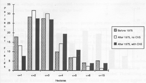
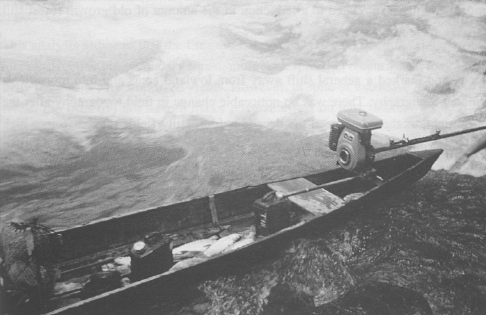
Long Segar residents estimate that a man with a chainsaw can clear ten times the amount of land in the same time as a man with an axe. In 1980, it appeared that chainsaws were having an effect on the size of ricefields being cleared by the Uma' Jalan (Colfer 1983).
In Figure 9, a comparison is made of average field area cleared before and after the introduction of chainsaws (in 1975). Although significant, the differences are less striking than anticipated. A reasonable explanation for the similarity in hectarage cleared by families with chainsaws and those without is the strong Uma' Jalan emphasis on sharing, in effect making owners' chainsaws available to others as well.
The fact that adoption of chainsaws does not have a more striking effect on overall field size probably reflects labour bottlenecks in other phases of rice cultivation. Mayer (1989) notes this factor in recording that communities did not significantly expand their areas of cultivation after the 1983 burn, when much naturally cleared land was available. Limits imposed by the need for land of neighbouring commu- nities also tend to inhibit the Uma' Jalan from clearing greater areas.
The chainsaw may have been expected to grant men greater opportunities to leave for work elsewhere once land clearing was complete. However, the increasing involvement of Long Segar men in rice production (see section on "Population," Ch. 3, p.71) suggests that this is not the usual case. An issue related to field size is clus- ter size (see Table 1, p.31). While it appeared at first that clusters were increasing in size because of chainsaw availability (in 1979-80 there was one cluster of 56 fields - the largest in the total data set), field clusters opened after 1975 do not appear to be larger, on average, than those opened earlier.
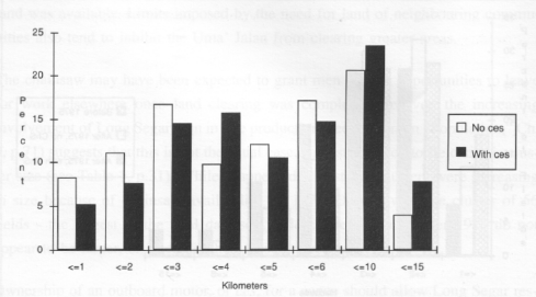
Ownership of an outboard motor, or ces, for a canoe should allow Long Segar residents to travel farther and hence cut more forest. After the arrival of the ces in Long Segar (1976), in general families with a ces had rice fields further from the village (Figure 8). The distance to fields made by families without a ces (n=405) averaged about 5 km; those with a ces (n=1,132) averaged 5.6 km. Again, this was a less dramatic difference than might have been expected. However, the further the distance to the field, the less accurate people's estimates of distance tend to be. For instance, fields in the Pantun area (see Figure 3, p.30) are actually 16 km from Long Segar as the crow flies, and more than 20 km by river, yet they were reported as only 10-15 kilometres away. Real differences in distance may thus be considerably greater than represented here. The Uma' Jalan tend to make their ricefields in clusters with other families, which reduces the necessity for each family to have its own ces and thus also minimizes the differences in distance to fields between owner and non-owner families.
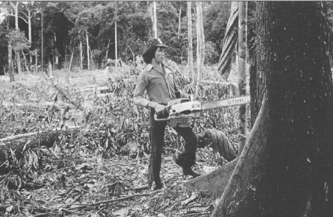
Clearing a field with a chainsaw
Figure 9
The effect of chainsaws on hectarage cleared (before 1975, and after 1975 with and without chainsaw), Long Segar
The agro-ecological pattern of events from 1980 to 1984 is interesting because of the long drought of 1982 and its aftermath. The drought continued until the month of June 1983, during which devastating fires raged across roughly three million hectares, including the area surrounding Long Segar.13 Based on aerial surveys (Wirawan 1987), damage done by the drought and fires in East Kalimantan was classified into three categories. Long Segar is in one of the most severely damaged areas, where over 50% of the canopy trees were killed. Muara Wahau was coded as affected by drought and fire damage causing up to 50% of the canopy trees to be killed. The area southwest of Samarinda, where Tanah Merah is located, was characterized in this report by a predominance of shifting cultivation and secondary forest. Forest damage was thus not evaluated. Long Ampung was not considered to be within the area significantly affected by the burn.
An outboard motor, or ces, on a canoe
Figure 10
The effect of the outboard
motor (ces) on distance to
fields, Long Segar
Between 1980 and 1984, roughly 1,655 ha were cleared (estimating 157 hectares per year for the 58 families which moved away shortly after this period 14). The average percentage of fields cut from old growth during this period went down to 64%, but it ranged from a low 42.3% to a high of 78.8% during the year of the drought. This high percentage during the drought reflects the fact that old growth forest is more difficult to dry properly, and dry weather during the felling and drying season makes this forest type more attractive. There was a similar pattern during the 1972 drought, when more easily accessible old growth brought the percentage of this type cleared up to 92.5%.
Again, the drastic reduction in cutting of old growth after the drought repeats the 1972 pattern, except that after the 1982 drought, use of old growth never again went above 69.5%. As ten years earlier, there was an increase in cultivation of the previous year's fields and in the use of relatively fertile old secondary forest. This is almost certainly also related to a reduction in the amount of old growth forest still available for cutting.
This period marked a general shift away from lowland areas and into more fields of mixed topography. There was no noticeable change in field topography after the big drought, as there had been the decade before. Hilly fields ranged from a high of 91% during the year of the drought, to a low of 62.3% the year before. In 1980 there was a large increase in families with only one field, to 83.3% from 57.7% the year before. This trend continued through 1984, when more than 90% of families cultivated only one field.
The ability to survive the period from early 1983 until their next rice harvest is indeed a tribute to the flexibility and adaptability of the Uma' Jalan system. The Telen, a large river normally navigable by quite large riverboats, dwindled to a trickle so small that at times the people could not bathe. The forest fires raged all around the village, requiring concerted (sometimes heroic) community efforts to prevent them burning down the village itself.
When asked how they managed to survive, people gave many answers. The most universal was "uman ubi" (we ate cassava); they hunted and fished; many villagers of both sexes went up the Marah River to pan for gold15; some hunted snakes for their skins. Thus, in general, it was their extensive knowledge of the forest and its riches which permitted them to live through such a difficult time.
There has been much speculation on the causes of the fires, and there is a tendency to lay the blame on shifting cultivators. As residents in the forest, they may well have played a role, but their role has probably been exaggerated. The shifting cultivators of East Kalimantan typically burn their fields in August, long before the major fires of early 1983. Logging, by opening the canopy of humid tropical rainforests, dries them out significantly compared to their undisturbed state, making forest fires much more likely. The 1972 drought, which was probably worse (based on rice production data) than the one in 1982, did not result in major fires. The area was already inhabited at that time by shifting cultivators, but mechanized logging, quite active in 1982, was only in its infancy in 1972.
There are various hypotheses about the effects of the fires that raged over eastern Borneo in 1983. The economic losses from burned timber and the damage to habitat for wildlife are evident. There has also been much speculation about possible long-term adverse effects on agriculture in the area. In the case of the Uma' Jalan, rice production was not significantly different before the fires and after. Prior to the fire the average family had 3,186 kg of rice available, while after the fire it had 3,093 kg.16 The yield per field appears marginally higher after the burn than before (Figure 11). The average yield per ha in typical years before the fire was 1,152 while after the fire it was 1,236 kg.
This analysis indicates that the fires did not decrease rice production. The use of the more productive old secondary forest, more widespread in recent years, may be partially responsible for improved yields. However, in spite of extensive damage to the forest, the fires did not have a major adverse effect on agriculture.
Although the direct impacts on rice production may have, been minimal, the effects of the bum on the agro-ecosystem as a whole were not. The depopulation of Long Segar was precipitated by a complex of factors, but they certainly included the negative impacts of the bum on the villagers' diversified subsistence base.
The disastrous environmental tragedy of 1982-83 prompted some families to leave Long Segar immediately in search of food. A few headed for areas closer to Samarinda, settling in Karang Umus and a logging company's abandoned basecamp on the Jembayan River (later named Tanah Merah). These Uma' Jalan "pioneers" were impressed with the ease of access to medical, educational, employment and marketing opportunities, just as the original settlers of Long Segar had been.
Meanwhile there were internal power struggles taking place in the Long Segar leadership. The older leaders were replaced by younger men. The Catholic and Protestant sub-groups within Long Segar were becoming solidified as well, and political infighting was getting out of hand - as it had in Long Ampung some 20 years earlier.
Some time after the great fire, Muara Wahau's camat (executive officer of the Kecamantan) offered Long Segar villagers the opportunity to join the newly completed Transmigration site at Muara Wahau. A group of nine families moved to Muara Wahau in 1986, and another 15 families joined them in 1987 (see section on "Life in Muara Wahau" in this chapter, p.53).
The first family moved to the abandoned logging camp (later Tanah Merah) in 1983, during the height of the drought. By 1985, Tanah Merah was firmly established, with 16 families of Uma' Jalan Kenyah living there.
This period was also marked by the adoption of gerobeg, a two wheeled pushcart, which came to Long Segar in 1984 and is quite common now. The set of wheels cost $26.00 in 1991, and people made the body of the cart from locally abundant wood. The gerobeg has increased efficiency in transporting things between home and field. This is most significant at harvest time: a gerobeg can carry 16 belek (11 kg tins) of rice while a person can only carry three.
This device prompted the maintenance of much better paths between the village and fields to the west and in Pantun, and the maintenance of the logging road there. It has also changed people's assessment of the utility of logging roads. In the Pantun area, fields now line the logging road, not the river. This pattern, new to the Uma' Jalan, is a common one in other areas, and has been identified as a frequent precursor to serious environmental problems.
A gerobeg
by the Pantun River
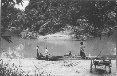
In order to compare rice yields in recently logged and unlogged areas, the data were divided into three areas by river system. The land in the Lalut Adau and Segar river systems, draining into the Telen from west of Long Segar, has not yet been logged by a timber company;" neither has the Kernyanyan river system which drains into the Telen to the east. The Pantun river system (draining into the Telen northeast of Long Segar) was logged by a timber company and subsequently farmed by Long Segar's residents.''
Between 1985 and 1990, roughly 1,456 hectares were cleared.19 The percentage of old growth being cleared is predictably in a downward trend, ranging from 70% to 56% during this period, well below the overall average of 73% for the 28 years. There is a consistent pattern: the younger the forest successional stage the fewer the fields. There was no significant change in field size over time.
There is also a consistent topographical pattern dominated by upland areas, which accounted for 59%-78% of the fields. Mixed topography ranged between 15% and 27% and lowlands between 5% and 8%. The percentage of families with only one field, between 77% and 89%, followed no discernible trend. No one had more than two fields after 1980.
A significant percentage of families began making fields on the Pantun River during this period, near Batu Redi, a logging company base camp. This area had been recently logged, providing an opportunity to compare yields in this area with yields in areas that had not been logged.
Kemyanyan (considered comparatively fertile by local people) had the lowest mean yields, with 1,162 kg/ha. Lalut Adau/Segar, which had not been logged because of its inferior timber stands, had a mean of 1,212 kg/ha. Pantun, the logged area, had a mean yield which was significantly greater than the other two with 1,379 kg/ha. Thus recently logged forest appears to be somewhat more agriculturally productive than unlogged forest.
This finding is linked to the earlier finding that ricefields made from old secondary forest were more productive than ones from old growth. Most of the nutrients in tropical rainforests are tied up in the above-ground biomass. The leaves of some of the species that dominate secondary regrowth are more nutrient-rich than the leaves of species that dominate in old growth (Soedjito 1985; 1990). The disturbances caused by logging create gaps, allowing the secondary species to get established, thus potentially contributing to increased soil fertility.21
Logged over forest, typically drier, also contributes to a more complete bum, thus making more nutrients from the ash available to plants (counter-balanced, however, by the loss of large trees). A good burn also reduces weed problems even further than the typical old growth reduction in weeds, thus adding to the potentially beneficial functions of logging. This issue has important policy implications in efforts to enhance the productivity of shifting cultivation systems.
Uma' Jalan shifting cultivation patterns were studied in three other locations: Muara Wahau Transmigration Site, Tanah Merah (near the capital city, Samarinda), and Long Ampung (the remote Uma' Jalan homeland). It becomes clear that shifting cultivation varies in different contexts. Yet the model on which the system is based remains: forest clearing for rice cultivation in all cases is followed by cultivation, care and harvesting of a variety of products from the varying stages of forest regrowth. The system depends on and maintains a forested environment and a small population. The potential for imbalances and problems derives primarily from external pressures such as logging, mining, in-migration, and food crop or plantation agriculture.
Transmigration projects are organized by the government, and planned according to a relatively standardized process. All people in one location are provided with predetermined inputs based on the model deemed most appropriate in that particular setting. New houses are identical, and each family is provided with the same amount of land, with fairness a major consideration in planning. All families typically receive specified inputs, like agricultural implements, seeds, seedlings, fertilizers, pesticides, agricultural extension services, family planning, and so on. They may also receive seed stock for domestic animals, fish fry or other inputs, depending on the particular plan for that location. The settlers are intended to practice settled agriculture or agroforestry.
The involvement of local people in Transmigration projects is another attempt to ensure fairness in the distribution of government aid. Despite good intentions, this effort has not been as successful as hoped. Local people frequently join transmigration projects for a year but then desert them when the year of subsidy ends.
The Muara Wahau project, located 36 hours by longboat from Samarinda, was intended as a PIR (Perkebunan Inti Rakyat, or nucleus estate and smallholder, NES) transmigration project (Sakuntaladewi and Amblani 1989). PIR projects usually involve a central plantation with associated processing, extension and marketing facilities. Transmigrants are brought in, given two to five hectare plots, and instructed to grow the same plantation crop.
The theory is that in this way, the settlers can take advantage of economies of scale, working together with the central plantation; and they can have access to extension and wage labour opportunities from the plantation. At the same time they also practice subsistence farming, gradually developing their own smallholder tree crop plantations.
The Muara Wahau Transmigration Site grows coconut and oil palm. The immigrants were to receive 0.25 ha for the house and home garden, one ha for food crops, and two ha for a tree crops orchard. The home garden and food crop plots were cleared by heavy equipment, a practice known to cause soil compaction in these fragile and infertile soils. The two ha plots set aside for individual orchards were not distributed until early 1991.
Settlers from Long Segar, previously involved in a resettlement scheme, were familiar with government assistance of this kind (though the executing agency differed). There has not been the kind of mass return back1home that occurs in some locations. By and large, those who moved to Muara Wahau are staying there.
In 1986, nine families moved to Muara Wahau to join the project; by 1987, that number had swelled to 24. Four more came in 1989, and one left in 1990. The homogeneity of this population is similar to Long Segar's early years: all community members are Protestant commoners. The Kenyah agricultural system that has evolved to date in Muara Wahau is different both from the intent of the Transmigration project and, to a lesser degree, from the pattern in Long Segar.
The one and a quarter hectare plots given initially to all Transmigrants were cleared by the project prior to settlement, and were thus exposed to the elements for some time prior to use. The Kenyah used the one-hectare plot for rice the first year, but complained about the quality of the soil. They referred to these plots as bekan (last year's ricefield), even though the plots had yet to be planted. Over 55% of the farmers complained of poor soil the first year (1986); and 71% complained of this problem the next year. After 1987, no one farmed their government-supplied plot for rice, most planting it instead with tree crops. The Uma' Jalan resumed shifting cultivation for their subsistence needs, and no longer complained of poor soil. Between 1987 and 1990, 95% of the new fields were cleared from old growth forest. Until 1987 (while the project lands were being cultivated) a higher percentage of fields were located in lowlying areas than was the case in Long Segar (78% in 1986, and 62% in 1987). Each subsequent year, the percentage of lowland fields decreased, from 42% in 1988 to 15% by 1990. Upland areas went from about a third of the fields in 1988 to half by 1990, while mixed topography increased each year, up to
37% in 1990.22
Average yields are considerably lower in Muara Wahau than in Long Segar for the five year period (Table 5 and Table 7, p.61), though it seems probable that yields will go on meeting subsistence needs if the shifting cultivation system is continued. An average of 59% of the families, over the five year period, felt they had not produced enough rice to feed themselves. An average of only 0.9% reported good yields over the same period. Significantly, by 1990 about half the transmigrants from other provinces had begun adopting this shifting cultivation pattern.
Fields were significantly closer in Muara Wahau than in Long Segar, though the average distances grew yearly, from 0.4 km the first year to 2.9 km by 1990. Mean hectares planted approached the Long Segar average of 2.7 after people stopped planting rice in the assigned one-hectare plot. The mean passed from under one ha in 1987 to 2.2 ha in 1988, 2.9 ha in 1989, and 2.8 ha in 1990. In Muara Wahau only one family planted more than one field per year.
Landslides were a problem in this area which did not exist in Long Segar, affecting from one to three fields a year. Flooding was a problem during the early years, when many fields were planted in the lowlands, affecting from two to seven (nearly 30%) fields in the years up to 1988. Short-term droughts were a serious problem in 1990, affecting 21 fields, or nearly 80% of the total.
Animal pests, as in Long Segar, include rats, pigs, monkeys, deer, and birds. Rats were the biggest problem, affecting at least 25% of the fields.23 Nearly 90% of the fields were affected by one or more of these pests. Not surprisingly, the incidence of this problem increased after people returned to making ricefields in the forest. They represent a significant risk for rice production, as they did in Long Segar. In 1990, the year of the shortterm droughts, insects and disease were reported to have attacked all fields but one. In more normal years about half of the fields were thus
affected.24
Other minor problems included empty seed pods, late planting, inadequate weeding, lodging, incomplete burns, bad extension services, hard rains during flowering and a first planting dying.
FIELDS CULTIVATED |
AVERAGE YIELD |
AVERAGE DISTANCE | |||
Year |
N |
AVERAGE SIZE (ha) |
TOTAL AREA (ha) |
KILOS PER HECTARE |
TO FIELDS (km) |
1986 |
9 |
0,81 |
7,33 |
494 |
0,36 |
1987 |
24 |
0,7 |
16,83 |
860 |
0,5 |
1988 |
2,16 |
51,75 |
1003 |
2,03 | |
1989 |
2.91 |
81,5 |
1268 |
1,86 | |
1990 |
27 |
2,8 |
75,67 |
463 |
2,89 |
OVERALL AVERAGE |
1,8766 |
46,616 |
817,6 |
1,528 | |
TOTAL |
233,08 | ||||
These are the same kinds of problems encountered by Long Segar's farmers. However, the labour problems appear to have been more severe in Muara Wahau than in Long Segar, most often due to human illness. Fields adversely affected averaged 31%, up to nearly half in 1990. Illness may have resulted from contact with new strains of disease carried by ethnic groups from other islands, though this is not certain. The incidence of illness affecting agricultural labour appeared to be going up.
There was a lower level of ownership of the chainsaw and the ces in Muara Wahau than in Long Segar. In 1990, only four families (15%) owned an outboard motor, compared to Long Segar, where 74% of the fields were owned by people with a ces. Chainsaw ownership was likewise only three in 1990 (11%), compared to 31% of the fields cut by people with a chainsaw in Long Segar.
The move from Long Segar to Muara Wahau was intended by the government to comprise a rather complete (and benign) change of lifestyle. The "marauding" shifting cultivators were to take on the more "civilised" methods of settled agriculture. They were to move gradually through settled, subsistence food crop cultivation on 1.25 ha to greater economic involvement in plantation crops, in this case coconut palm, on an additional 2 ha.
The intended change did not survive the second year of settlement. After two years of inadequate rice production, there was a return to the traditional system of shifting cultivation using mainly old growth forest. The two hectares intended for small scale coconut plantations were not given out until early 1991; details of crop management and price determination with the central plantation company remained unresolved in April 1991.
Living in near other ethnic groups that are more cosmopolitan has had some effect on the Kenyah, who appear to be gaining experience and involvement in commercial activities, like buying and selling their produce, which were minimal in the past. An informal division of labour has emerged, with the Uma' Jalan becoming major suppliers of fish to the other ethnic groups. In spite of this, it is difficult to conceive of a sustainable development direction for Muara Wahau that will not involve a reduction in the quality of life for the Uma' Jalan. Many transmigrants from other islands have begun to adopt the Dayak pattern of shifting cultivation, and it seems probable that this trend will expand, given the infertility of the soil. Without significant outside subsidy, the soils in the area are not good enough to support settled food crop farming, and there are currently few alternative sources of subsistence.
Shifting cultivation practiced by large numbers of people concentrated in a small area can produce devastating environmental effects. It seems probable that the area around Muara Wahau will be denuded of forest fairly quickly, as more and more people adopt shifting cultivation as the only viable way to subsist in that environment. Unless corrective steps are taken, the periods of forest fallow will be shortened unsustainably to accommodate the large population .
The original plan involves converting the forest in that area to plantations. Although this solution may, in the long run, be better for the transmigrants (most of whom have come from situations of extreme poverty and hardship), it does not benefit local population. The smaller number of Kenyah owning chainsaws and outboard motors in Muara Wahau compared to Long Segar is evidence of a reduction in standard of living. The traditional way of life in East Kalimantan, which sustains a higher standard of living than one finds in much of rural Java, is in danger. So are the forest resources on which that way of life (and much national income) depends.
Tanah Merah is an interesting case because its people have more or less replicated their lifestyle from a more remote area, in a location near the city. The process of settlement appears similar to that observed in Long Segar. It is possible that the Tanah Merah experience will be a template for what lies ahead for other Dayak groups, as the external world penetrates the interior of Borneo.
Tanah Merah was settled by a widow from Long Segar in 1983, after the Big Burn; the next year three more families arrived. They all made single fields in old secondary forest, one in a hilly area, two on mixed topography.
By 1985 there were 16 families, and the pattern of forest use was similar to that in Long Segar: 47% old growth, 24% old secondary forest and 12% young secondary (the remainder were mixtures of forest type), with 88% of the families having only one field.
In 1986 there were 29 families from Long Segar, and by 1990 there were 30, out of a total population of 43 families. Unlike the move from Long Ampung to Long Segar, there was considerable communication between the Uma' Jalan of Long Segar and Tanah Merah due to the ease of transport between the two villages. Tanah Merah also included 9 families from two other Uma' Jalan villages, Sentosa and Gemar Baru, also composed of people originally from Long Ampung.
The distribution of one and two field families in Tanah Merah followed no particular pattern, with 40% having two fields in 1990. Forest use demonstrates the usual Uma' Jalan preference for older forest. The percentages of fields in each forest type over the eight year period of settlement were 52% old growth, 25% old secondary, 15% young secondary, 2% ex-ricefield and 6% mixtures of forest types. Tanah Merah inhabitants followed a slightly different topographical pattern from those in Long Segar, with hilly areas most common (62%), but with lowland areas second (27%), and mixed topography used least (11%).
Fields were considerably farther away in Tanah Merah than in Muara Wahau, but not very different from recent distances in Long Segar. Average field size was smaller than in either of the other two locations, never surpassing 1.8 ha, as compared to highs of 2.9 in Muara Wahau in 1989 and 3.3 in Long Segar in 1968 (Table 7). This probably reflects greater Tanah Merah involvement in the cultivation of banit (gardens or orchards). Although, in more remote areas, one of the most often cited disincentives for moving nearer the city is shortage of land, only one Tanah Merah family in these eight years complained of this problem.
Yields were higher in Tanah Merah: the average ranged from a low of 936 kg/ha in 1990 to a high of 1,550 in 1989. This is not unexpected, as soil conditions were better in this area than in Muara Wahau or Long Segar (Brotokusumo, pers. comm. 1991). Tanah Merah land has all been logged, which may also have a positive effect on yields (see section above on "The Effects of Logging"), though better inherent soil conditions are a more likely explanation in this case. Thus family rice production in Tanah Merah was doing quite well, with 76% of families reporting good to sufficient yields since first settlement.
Given the more common use of lowlands and the logging history in this area, flooding might be expected to be a problem. However, almost no fields were flooded out, the worst year being 1987, when 4 fields suffered this fate. Short-term drought was a bigger problem, affecting 30% of the fields overall, but reaching 64% in 1990. Animal pest depredations were less extreme than in the interior settlements, affecting less than half of the fields overall. Again, insects and disease were less of a problem in Tanah Merah than in the other two areas, affecting less than a quarter of the fields.
Labour shortage due to illness was a greater problem than in Long Segar, but less severe than in Muara Wahau, with an average of 14% of fields affected by family illness, and another 9% by shortage of female labour for other reasons. The same repertoire of agricultural problems as elsewhere were cited: bad bums due to unusually rainy dry seasons, poor growth of rice plants, weeds, and late harvesting due most often to illness.
Over half of the families in Tanah Merah had owned a ces since settlement, with 22 families (60%) owning them in 1990. Chainsaws were also comparatively common, with 11 families (30%) owning one in 1990. The number of ces and chainsaws increased every year until 1990, a pattern closer to that in Long Segar than Muara Wahau, where ownership of both devices was considerably lower.
A rice field cluster belonging to Tanah Merah
When the villagers compared life in Tanah Merah with life in Long Segar, they often stressed the advantages of being near hospitals, schools, and markets. Many expressed disappointment that their dreams of making banit (gardens of tree and food crops) had not been realized as fully as they had hoped. There was concern about the ill effects of outside influences on youth, some of whom have turned to petty crime (mainly thievery and prostitution) .26 Many also complained about the quality of housing: Tanah Merah homes tend to be smaller than Long Segar homes, they have thatch roofs instead of ironwood shingles, and fewer have glass windows. But chainsaw and outboard motor ownership remain fairly high, suggesting that their overall economic situation remains reasonably good. Aspects of traditional rights of ownership have been in flux for some time (discussed below in the section on "Land Tenure," Ch. 3, p.77), and there is widespread confusion about issues that were once fairly clear. Although a few people bought land in Tanah Merah, most have followed the procedure used in Long Segar: they negotiate their interests with other groups in the area, and then use the land as mutually agreed.
Proximity to the city makes the issue of land ownership more critical in Tanah Merah than in the other Uma' Jalan communities studied. The headman in Sentuk, the formal village of which Tanah Merah is a part, instructed the Uma' Jalan that they would not be allowed to cut any more forest for ricefields in 1991. In April of that year they were planning to do so anyway. But they had begun to consider how best to intensify their agroforestry production and solidify their claims to land. Such a shift probably depends on government ability to grant them greater security of land tenure.
Year |
N |
FIELDS CULTIVATED |
AVERAGE YIELD KILOS PER HECTARE |
AVERAGE DISTANCE TO FIELDS (km) | |
AVERAGE SIZE (ha) |
TOTAL AREA (ha) | ||||
1983 |
1 |
0,67 |
0,67 |
1650 |
6 |
1984 |
1 |
3,5 |
1149 |
||
1985 |
18 |
1, a |
32 |
1471 |
4 1 |
1986 |
39 |
1,67 |
65,25 |
1541 |
3,68 |
1987 |
48 |
1,24 |
59,58 |
1323 |
4,51 |
1988 |
39 |
1.63 |
63.68 |
1527 |
6,35 |
1989 |
48 |
76.9 |
1550 |
6 52 | |
55 |
1,85 |
101.52 |
936 |
6,87 | |
OVERALL AVERAGE |
1,45 |
50,39 |
1393,38 |
5,16 | |
TOTAL |
403,10 | ||||
Possible development directions in Tanah Merah would seem to include tourism27 and the marketing of agroforestry produce. Being near the city opens a variety of options that do not exist in more remote sites. Produce can be sold in Samarinda and Balikpapan. Tourists can potentially come up the Jembayan River and pay to stay in a longhouse, watch villagers dance or accompany them to their fields and forests. Villagers have access to schools and other ways of life. The community is clearly approaching a crossroads. Will these Uma' Jalan, like the Bugis pepper farmers (see Ch. 1, note 5), begin to farm their lands in unsustainable ways, transforming them into grasscovered wasteland?28 Or will they be able to develop creative new solutions that build on and develop their existing system?
Recent land use practices in Long Ampung, the village of origin of the Uma' Jalan, are described by residents as characterized by easier availability and greater choice in land sites, since so many people have left the community. In fact, the population is almost the same as it was in 1980. The remaining villagers readily acknowledge that they now feel free to use the abandoned lands theoretically belonging to the emigrants .29 Some argue that land cannot be owned by individuals because it constitutes an inheritance from their (collective) ancestors and is intended for their descendants. Land ownership (forest, house, or home garden) is only acknowledged while the land is being cultivated or occupied. Once abandoned, the forces of nature, and not people, return the area to forest, so anyone should have the right to use the land as a source of livelihood.
Previously, when population pressure was greater, land rights were a bigger issue. Now distance to the potential field site is a more pressing consideration. When a person identifies a desirable forest location, he/she contacts the people who first made a ricefield there (if they are still in residence) and asks whether or not they plan to make a field there again. If not, the new person simply lets the village officials know his/her intention, and can then open the forest for a field. If the previous farmer does plan to make another field, the new would-be user must look for another place.
Agro forestry patterns, 1985-199030
The pattern mentioned above for Long Ampung of clearing and planting two ricefields, one close for easy access and a larger one farther away, remains common. Nearly half the families had planted more than one field during this period. Forest use is significantly different from the daughter villages, primarily because of lack of accessible old growth forest. Only 3% of the fields were cut from old growth and 22% from old secondary forest. Young secondary forest, the type most readily available, accounted for a full 74% of the clearing. The use of the different topography types is similar to that in Tanah Merah, with upland most popular (as in all locations, probably because hilly areas are most abundant), at 45%, followed by lowland, with 29% and mixed topography with 27%. As with the forest use patterns, no trend is discernible.
Average distances to field (Table 7) range from 3.6 km in 1988 to 1.9 km in 1990, following a seesaw pattern with no trend. Field sizes are smaller than in any of the
The welcome sign at the Long Ampung airstrip
other locations, ranging from 0.8 ha in 1990 to 1.2 ha in 1987. Production is also lower, due to the reliance on young secondary forest for making fields, with average yields ranging from 658 kg/ha in 1985 to 899 kg/ha in 1990. Correspondingly, complaints about soil quality are quite frequent in Long Ampung. However, in the absence of a market, there is no felt need to increase production: 75% of Long Ampung residents report their yields to be good to sufficient over this period.
Over this six year period, flooding affected 24% of the fields (reaching 42% in 1985), landslides 8% and short-term droughts 10%. Animal pests are a major problem around Long Ampung. In 1990, all fields were significantly affected, and the lowest level of animal depredations in any year was 67% in 1985. Similarly, fields affected by insects and diseases reached 81 % in 1990, though they were as few as 42% in 1985. Labour shortage is a problem in Long Ampung just as in other areas. Yields on nearly half of all the fields examined were reported to be reduced by labour shortages.
The higher rainfall of the Apo Kayan area is reflected in the incidence of agricultural problems related to rain: rain damage at rice flowering and incomplete burns. The latter problem was rarer than could be expected, probably due to the use of secondary forest, which dries more easily than old growth. In 1980, there was one chainsaw in Long Ampung, but since there was no way to get fuel at that time, it was unusable. The first chainsaw appeared in 1986, and five families had them in 1990, though evidence suggests that they were used less extensively than in the more accessible sites. The ces is either less accessible or considered less desirable than in Long Segar and Tanah Merah: in 1990, only one of the 25 families owned one.
Long Ampung remains the most "traditional" of the Uma' Jalan villages, far from markets, regular sources of cash income, and other links to the modern world. The people of Long Ampung continue to farm much as they have for decades (perhaps centuries). Their use of secondary forest for rice fields, followed by harvesting of various products from the succeeding stages of forest regrowth, is a demonstrably sustainable use of the forest.
YEAR |
N |
FIELDS CULTIVATED |
AVERAGE YIELD KILOS PER HECTARE |
AVERAGE DISTANCE TO FIELDS (km) | |
AVERAGE SIZE (ha) |
TOTAL AREA (ha)* | ||||
1985 |
12 |
0,94 |
135,36 |
656 |
2,55 |
1986 |
15 |
1,14 |
164,16 |
815 |
3,36 |
1987 |
21 |
1,23 |
177,12 |
690 |
2,89 |
1988 |
33 |
1,11 |
159,84 |
806 |
3,63 |
1989 |
38 |
0,91 |
131,04 |
899 |
2,99 |
1990 |
42 |
0,8 |
115,2 |
834 |
1,93 |
OVERALL AVERAGE |
1,02 |
147,12 |
783,33 |
2,89 |
|
TOTAL |
882,72 |
||||
* These figures are estimates, based on the number of households in 1990 and the number of fields per household in the 1990 sample, The estimated 144 fields were multiplied times the average field size that year.
Yet this village too has undergone considerable change. Table 8 summarizes the changes that have occurred in recent years, but despite these changes, much remains as it was in 1980. Remoteness, combined with traditional interest in protection of the environment, makes this an ideal area for conservation efforts. The residents of Long Ampung have traditionally maintained a community forest preserve; they appreciate the beauty of their area and express interest in conserving it.
There are currently plans to make the Apo Kayan part of the UN Kayan Mentarang Biosphere Reserve, which would facilitate maintaining the traditional way of life, while taking steps to preserve a corridor of old growth forest along the MalaysianIndonesian border with East Kalimantan.31 In this context, a possible benign development strategy for the area is "eco-tourism." Tourism development could complement the existing subsistence system, emphasizing a resurgence of traditional arts (music, dance, adornments, ceremonies) and interaction with the environment. Many ordinary daily activities in Long Ampung are suitable eco-tourist activities (paddling up unspoiled rivers in a canoe, trekking to a ricefield, going pig hunting with a group of Dayaks). There is a need for advice on such things as setting standard prices, establishing homes where tourists can stay (or making a rotating schedule), improving toilets, constructing more private bathing facilities and translation.
A possible alternative or complementary development strategy is the marketing of useful, unique and high value forest plants or animals which could justify the expense of air transport .32 The research required for identifying such species could be included in the plan for a "Biosphere" or other Reserve.
CHANGE |
1960s |
1990s |
Field Location Animal population Human Population Salt Goods from outside world Communication with Samarinda Motorized water transport Chainsaw Elementary School Individual houses Longterm fields (pineapple, papaya, coffee) Sale of agricultural goods Foreign and domestic tourists Sale of gaharu wood Air transport Introduced plants Community health center |
far abundan many rare rare rar none none none rare some none rare none none few none |
near rarer few abundant available available available available available majority more available common common regular many available |
(Adapted from Hadisumuah and Sakuntaladewi 1991) | ||
