


It is possible to attain a meaningful if modest understanding of tenure in rapid appraisal only because in most customary tenure systems in Third World countries, different land tenures reflect different land uses. Different tenures exist to accommodate and organize those different uses. Where a different land use is visible, such as pasture or house gardens, pursue the question of whether there is a special tenure regime for land under that use. This will usually be the case. As suggested earlier, it will usually be possible to identify agricultural holdings, commons and possible reserve areas in the early stages of the rapid appraisal. This is the starting point: assembling an initial set of categories into which one can organize information.
The material will, however, become more complex, as where there are two commons, one for grazing and also a dense forest commons, with different rules as regards rights to use of trees; or where the holding has within it several tenure niches, such as a distinction between rights in "near fields" and "far fields," or some land under regular rotation and other land under shifting cultivation. What method do we use, when we want a more detailed image of tenure than the tenure niches which can be seen from observation of land use?
It is best to begin with a few key informant and small group interviews. A larger meeting attended by officials and notables of the area may be needed to explain the appraisal exercise, but such large meetings are not good opportunities to obtain reliable information on tenure rules. Notables may monopolize the information flow, and others may defer even if wrong information is given. In such meetings there is a strong tendency to state unequivocally traditional rules, even where in practice these rules are no longer obeyed. Such a meeting can, however, provide an opportunity to identify two or three individuals who are more thoughtful and articulate about the tenure system and able to present their knowledge in a more organized way. There may well be persons with specialized knowledge of the tenure system and its underlying ideology. The purpose of a talk with such key informants is orientation to the tenure system's basic concepts and vocabulary. It ís also useful at this point, if the focus is on a,reasonably small area, to walk through the area with a map. With the assistance of an accompanying key informant, key features on the ground can be related to the map, and their local names learned. Developing a map such as that by Fox, presented earlier, it is possible to establish the locations, appropriate areas and spatial relationships among the three broad types of tenure niche. A day or two should be spent on these activities at the outset, but not more. It is easy to get bogged down in such discussions, and it is important to move on to the farmers.
Some small group interviews may be arranged, but the most productive are usually informal discussions, held at the edge of fields, with farmers taking a break, or in a local bar. The quality of the interchange in such settings-in groups whose members often know and are easy with each other--tends to be better than in more contrived settings. Another promising setting is outside the local court, as litigants await their hearings. Indeed the local court and judge or judges, modern and/or traditional, are worth a few hours on the topic of disputes over land and trees in the areas. One can learn quickly which types of disputes are common, and identify trouble spots in the tenure system. These may reveal unexpected issues concerning a possible community forestry effort.
The early questioning in small groups should steer clear of questions such as, "Who owns the land?" or "Can land here be sold?" These questions incorporate too many assumptions. Rather it should begin with questions about people's use of trees, working from behavior to tenure. A line of questioning might run: "If a newly married couple wanted to build a house, where would they get the poles? How far away is that? What is that area called? Can they cut it or just gather it if fallen? Do they need to ask anyone's permission? If so, whose permission? Why that person? Can they take it at any time? As much as they want? Men and women? Any species? Can others take wood from there? Who? Can people from X also take wood from there? Why not? How can people from X be stopped from taking it? Who stops them? Why are they the ones who do it? Could the household who gathered wood take their oxen to graze there? Could they lop off branches for them? Could their goats browse there? Why not? Could they take goats at another time? Then where do their goats browse? How far is that?" And so on. One begins to find out what land and trees people have a right to use by finding out which ones they do use. Later come questions about the nature and basis of the entitlement. The questioning turns this corner into tenure as it asks what it is thought people should not and are not allowed to do, and seeks to distinguish these cases from what people simply do not bother to do for one reason or another. The nature of the rights emerge, and gradually it becomes clear how they are organized into the "bundles of rights" which are tenures.
Inquiring about land and tree use as a way into tenure provides a line of questioning which fits in more comfortably with the interests of the rest of the assessment team, who likely are foresters and farming systems analysts. It is important that the social scientist not regularly do his or her questioning alone, apart from the rest of the team, but instead help the other team members appreciate how people in the area think and behave about trees. When the foresters' questions turn to species, there are species-specific tenure questions to be asked: Can both men and women plant this species? Who could lop branches from it? Who would harvest the nuts? Who would sell them and who would get the revenue? Who could cut the tree down and sell it? Who would get the money from the sale? Patterns will emerge which can be compared later.
Even at this stage of the interviewing, a vocabulary in the local language for land and tree tenure must be developed. The "what is it called" question is a key one, as Fortmann suggests in the following excerpt. There may at times be a single term for a land use and a land tenure, and it is essential to get these definitions sorted out early on. There are also terms such as "parcel" (a unit of ownership) and "field" (a management unit), as well as "plot," "panel" and others which in English are often used interchangeably, with the meaning clear (if at all) only from the context. Similar difficulties in the local language can seriously mislead the interviewer. There may be only one term for several different land units. It is almost impossible to clarify the use of these terms in abstract discussion. The usage will only become clear when the terms are tried out in different pieces of the holdings of the first households interviewed. This is necessary even for team members who speak the local language, but may not have previously become involved with tenure terminology. That terminology can be very simple or very complex depending on the case at hand. The same is true of tree species terminology. Where several team members are interviewing, it is important that they regularly check with each other on the way they are translating key words. Where there is time, the translation of a question schedule into the local language by a different translator is usually revealing. Even done orally in the case of particular questions, this is a useful way to proceed.
Even at this stage, it is important to remember that communities are far from homogenous. There has been continuing concern over whether agroforestry and community forestry generally are adequately addressing the needs of the poor. The poor must be consulted in the appraisal, whether these be those who gather twigs and sticks on others' lands or tenants who farm others' land. Where a project involves substantial intensification of use with trees it may destroy rights of other users of the land and trees on it. Gathering rights may be lost.
Women are a group who are often neglected in project design exercises and whose situation often requires particular attention. The excerpt included here from Hoskins indicates the need to include women in discussions early in the planning of a project. Women must be consulted because agriculture depends so heavily upon their labor and, often, upon their management decisions. The integration of trees into a farming system requires that women be consulted. Moreover, women are often in quite a distinctive tenure position regarding trees and rights in trees. They may or may not have the same rights in land and trees as do men, and may in fact not be allowed to grow certain species of trees or grow trees in certain tenure niches within the holding. The excerpt from Rocheleau identifies two niches as critical for women, the home garden and the commons.
In some contexts there may be problems involved in men interviewing women. The rapid appraisal format permits no time for local people to develop confidence in a researcher, so inclusion of a woman member on the team is advisable and in some cases may be absolutely necessary. While contacts with women may be a bit difficult, there are places where women gather, at the well or at the stream for washing. The location will vary from place to place, but it is useful to question them at these sites, away from their husbands.
Such questions can be put to community members encountered throughout the appraisal, during informal interviews, on buses, in bars, or, best of all, walking through the fields. This is a good way to learn about particular kinds of rights in land and trees, to learn about their names and to begin to get a sense of their relative importance. The appaiser refines his or her sense of the tenure niches in the landscape, and learns how these niches are arranged in relation to each other.
We need to focus on one level of detail deeper than that of our "tenure niche." The focus has so far been on broad tenure niches in the appraisal area--tenure as seen from an airplane, or an aerial photograph. It is useful because the niches provide us with units with common sets of tenure issues. But now we need to shift to the viewpoint of the household, the typical unit of production and use. It is the household and its members who make the decisions about trees and tree products and it is their behavior which projects seek to alter. If trees are to be planted, they will have to plant them, whether as individuals or as members of the community. Since we usually cannot force them to plant trees, we need to ensure that they have the necessary incentives. Incentives may arise from household need or the opportunity to market the trees, but they are influenced by tenure. Land, the very opportunity to produce, comes subject to certain tenure terms which affect incentives. No farmer, for instance, will plant seedlings in an area over which he does not have sufficient rights to exclude to prevent their being devoured by others' livestock. We need to understand better how tenure influences household and individual decision-making.
To do this, we need to think of the household's landholding. The holding will often consist of several pieces of land, sometimes widely dispersed. The holding is quite likely to be a multi-tenure holding. Multiple parcel holdings may have the advantage of providing a variety of land types each suited to a different use. Those different uses are likely to have different tenure implications, and so the several parcels of the holding are likely to be found in several different tenure niches in the landscape. The effect is that the household has tenure of a different nature on the several different parcels in the holding. It also has tenure which extends beyond the holding. The "holding" consists of parcels of land in which the household has rights to relatively exclusive use, but the household will have rights in other lands as well, such as rights to use trees in a communal forest or rights to gather firewood on someone else's land.
At the household level, the need is for a long interview (2-3 hours) with several members of the household, including women, present. The opportunity to return for subsequent interviews or to interview different household members separately may or may not materialize in the rapid appraisal context, though of course it is advantageous. The objective is to get a dozen or more thoughtful, probing household case studies. The concern should be with quality rather than quantity. If a household seems uncommunicative, don't take it as a challenge. Time is too valuable; move on. A question schedule rather than a questionnaire should be used. The question schedule should not be finalized until one has been in the appraisal area for several days and has oriented oneself to the tenure system. Even then, it can be changed as one proceeds. The laptop computer is a godsend for revisions in these circumstances. Data from these interviews are not going to be analyzed across households, so rigorous comparability is not necessary. And open ended questions, attitudinal and opinion questions have a vital role. If you want to know how people might react to a particular opportunity, ask them.
How should the households be selected? There is no simple answer; it depends on how long the appraisal team will be in a given locality. If only for a day, as with a team which is trying to cover a large area, possibly seeking to select a site, then you should be glad for any household you can get which is kind enough to give you its time on such short notice. If the household turns out to be unusual in some important way, this should be noted. But if one has a little longer, you can be more ambitious. A minimal objective is to avoid interviewing several households which are highly unrepresentative. On the other hand, a statistically valid representative sample is unlikely to be possible. One could stumble upon a village which has just compiled a list of households and sample it, but that will not often happen. In fact, such a local list should be examined critically. The manner in which and for which it was compiled should be understood thoroughly before using it. Such lists are compiled for specific purposes. Consistent with the purpose, there are often omissions, and they tend to be systematic. Landless or very poor households are commonly excluded. If the assessment is taking place in an area with a history of project or other research, there may actually have been random sampling and interviewing of households. If it is possible to obtain the list of households and household data from such a survey there can be great benefits to reinterviewing some or all of those households and being able to look at relationships between the already available household data and the answers to your questions on land and tree tenure.
But the above situations are unusual, and in practice one must often rely on guidance from a local contact, possibly a local leader who meets the appraisal team, to identify the households to be interviewed. How can you communicate what you want? There should be several "typical" households, households that fall somewhere near the mean in the community in terms of landholding, farming system and wealth. But it is also important to cover a certain range; the mean can be misleading in a society in which distribution of resources is bimodal. One should also have a list of special characteristics which one wants to include. Some categories are fairly universal: female-headed households, poor households, wealthy households, labor-rich and labor-poor households. It will often be particularly difficult to find poor and female-headed households. The local contact is likely to steer you away from them and toward households he or she regards as more successful and as "knowing more." Explain that you need to know the needs and capabilities of the disadvantaged households as well. Other specifically targeted groups will be particular to a specific location or the type of project activity envisaged: a household from a particular caste, a household that has sizeable livestock holdings, or even the household that owns the orchard you saw a mile back down the road, the only one you have seen on the trip. This last point is important. If a few local people grow trees while most do not, interview some of that minority of households and try to figure out what makes them different.
One of the tools in the interview and an important means of recording information is a sketch map of the household's holding and tenure. This is a variant on the sketch map regularly used in agricultural censuses. An example of such an agricultural census map from Swaziland is shown on the following page. Labelling the areas of land according to local tenure classifications can turn it into a tenure map. It is a communication tool, and because few farmers will have pictured their holding in this way before, creating a sketch map of it can generate considerable interest. Such a map requires a walk around the holding, possibly going up onto a hill from which you can see several areas in which the household has tenure. Such a map is indispensable when working with households which have more than two or three parcels in their holding.
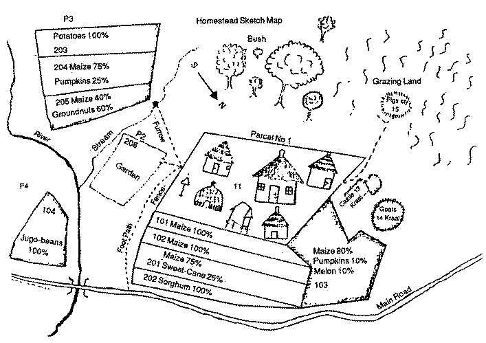
Central Statistical Office, "Enumerator's Instruction Manual for Swaziland Census of Agriculture, 1983-1984, Phase Two, Part I, Area and Yield Measurement" (Mbabane: Central Statistical Office, 1984), p. 6.
This sketch map approach can also be used to explore interhousehold dynamics. Men and women in a household often have very different rights and responsibilities for land and trees. Rocheleau has prepared a number of maps which use the terms "responsibility," "control," and "labor" to describe rights and responsibilities of male and female household members for trees on each parcel, and examples from the Dominican Republic, India and Zambia are given on the pages which follow. This author would usually be satisfied with a coding in terms of authority to manage, responsibility to provide labor and right to dispose of the product. The Rocheleau maps specify gender. Such distinctions can be important, as we will see in the next two chapters. These useful shorthands for sketch maps are, of course, no substitute for a careful specification of the extent of each household members' rights in the land and trees.
How much can one learn about tenure in a rapid appraisal? Can one both acquire all of this rather specific information and also find a general framework which provides a more holistic understanding of the tenure system? Very possibly not, but the framework probably matters less than the specifics for our purposes. To spend much time constructing the framework at the expense of detail about behavior can in this time frame produce misleading results. Customary systems have their own gap between norms and behavior. Rules which are disregarded with some regularity may be stated as eternal verities by local customary law specialists. Important lines of inquiry tend to be foreclosed by formal statements of customary rules. Good long-term research involves sorting out these discrepancies, but in a rapid appraisal there is not likely to be time to recognize a false lead and reopen the line of inquiry. This is the reason why this paper suggests that we work from behavior to rules, rather than vice-versa.
Of course, one may have acquired some sense of the "big picture" by the end of the rapid appraisal. Some local people may have been able to articulate the system effectively. Or one may have read a book or paper about the system before going into the field. It is in the last stages of the appraisal that one should return to key informants and specialists and try out one's perception of the formal rules and structure of the system, when one has a great deal of specific information against which to test generalizations. If one has begun to have ideas about opportunities or strategies or nagging concerns about problems, they should be raised with key informants. Rural people are not deficient in imagination; they will understand what you are getting at and you may be surprised at the perceptiveness of their questions and comments.
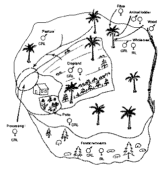
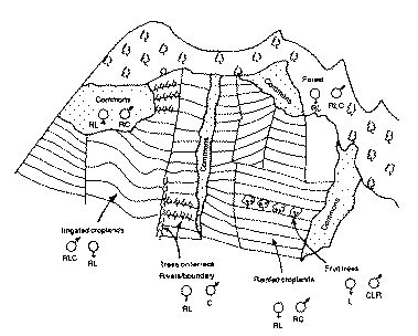
R - Responsibility to provide a product thereof to household. L - Labor input for establishment, maintenance or harvest. C - Control of resource or process.
Dianne Rocheleau, "The User Perspective and the Agroforestry Research and Action Agenda," in Agroforestry: Realities, Possibilities and Potentials, ed. H. Gholz (Martinus, Nijhoff, Dordrecht, 1987), at pp. 68, 71.
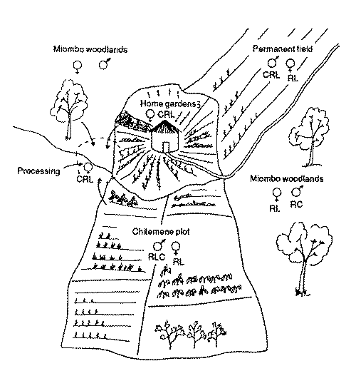
R - Responsibility to provide a product thereof to household. L - Labor input for establishment, maintenance or harvest. C - Control of resource or process.
Dianne Rocheleau, "The User Perspective and the Agroforestry Research and Action Agenda," in Agroforestry: Realities, Possibilities and Potentials, ed. H. Gholz (Martinus, Nijhoff, Dordrecht, 1987), at p. 75.
